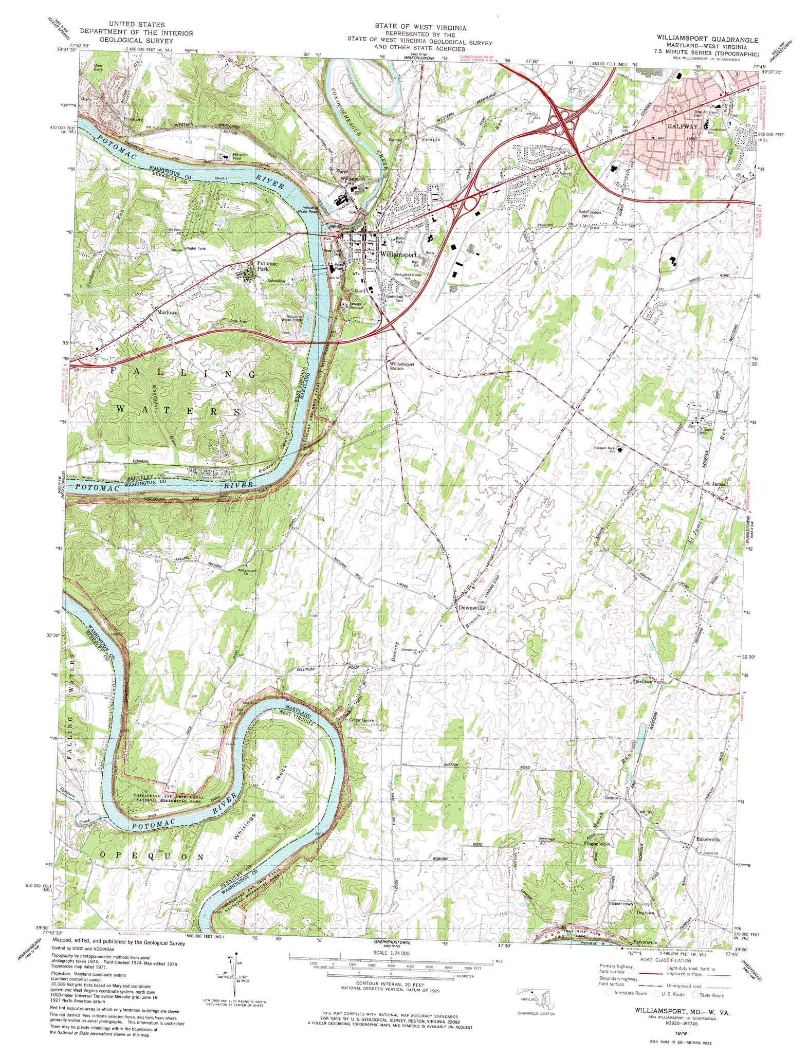
Williamsport Topo Map Maryland
To zoom in, hover over the map of Williamsport
USGS Topo Quad 39077e7 - 1:24,000 scale
| Topo Map Name: | Williamsport |
| USGS Topo Quad ID: | 39077e7 |
| Print Size: | ca. 21 1/4" wide x 27" high |
| Southeast Coordinates: | 39.5° N latitude / 77.75° W longitude |
| Map Center Coordinates: | 39.5625° N latitude / 77.8125° W longitude |
| U.S. States: | MD, WV |
| Filename: | o39077e7.jpg |
| Download Map JPG Image: | Williamsport topo map 1:24,000 scale |
| Map Type: | Topographic |
| Topo Series: | 7.5´ |
| Map Scale: | 1:24,000 |
| Source of Map Images: | United States Geological Survey (USGS) |
| Alternate Map Versions: |
Williamsport MD 1953, updated 1954 Download PDF Buy paper map Williamsport MD 1953, updated 1954 Download PDF Buy paper map Williamsport MD 1953, updated 1965 Download PDF Buy paper map Williamsport MD 1953, updated 1972 Download PDF Buy paper map Williamsport MD 1979, updated 1979 Download PDF Buy paper map Williamsport MD 1997, updated 2000 Download PDF Buy paper map Williamsport MD 2011 Download PDF Buy paper map Williamsport MD 2014 Download PDF Buy paper map |
1:24,000 Topo Quads surrounding Williamsport
Big Cove Tannery |
Mercersburg |
Williamson |
Greencastle |
Waynesboro |
Cherry Run |
Clear Spring |
Mason-Dixon |
Hagerstown |
Smithsburg |
Big Pool |
Hedgesville |
Williamsport |
Funkstown |
Myersville |
Tablers Station |
Martinsburg |
Shepherdstown |
Keedysville |
Middletown |
Inwood |
Middleway |
Charles Town |
Harpers Ferry |
Point Of Rocks |
> Back to 39077e1 at 1:100,000 scale
> Back to 39076a1 at 1:250,000 scale
> Back to U.S. Topo Maps home
Williamsport topo map: Gazetteer
Williamsport: Areas
Crazy Neck elevation 125m 410′Dellinger Wide Water elevation 99m 324′
Williamsport: Bends
Powell Bend elevation 108m 354′The Horse Shoe elevation 103m 337′
Williamsport: Bridges
Conococheague Creek Aqueduct elevation 103m 337′Williamsport: Canals
Chesapeake and Ohio Canal elevation 106m 347′Williamsport: Capes
Whitings Neck elevation 138m 452′Williamsport: Crossings
Interchange 1 elevation 139m 456′Interchange 2 elevation 134m 439′
Interchange 26 elevation 152m 498′
Interchange 4 elevation 152m 498′
Lemons Ferry (historical) elevation 103m 337′
Lights Ferry (historical) elevation 103m 337′
Williamsport: Dams
Guard Lock Number 5 elevation 102m 334′Lock 45 elevation 109m 357′
Williamsport Power Plant Dam elevation 102m 334′
Williamsport: Islands
Duck Island elevation 103m 337′Williamsport: Mines
Pinesburg Quarry elevation 133m 436′Williamsport: Parks
Byron Park elevation 127m 416′Chesapeake and Ohio Canal National Historical Park elevation 106m 347′
Halfway County Park elevation 176m 577′
Marty Snook County Park elevation 175m 574′
Potomac Park elevation 105m 344′
Williamsport: Populated Places
Bakersville elevation 129m 423′Cedar Grove elevation 109m 357′
Cloverton elevation 133m 436′
Conococheaque elevation 159m 521′
Dogtown elevation 120m 393′
Downsville elevation 141m 462′
Fairplay Farms elevation 141m 462′
Friendship Park elevation 177m 580′
Grimes elevation 115m 377′
Halfway elevation 184m 603′
Halfway Manor elevation 176m 577′
Heritage Estates elevation 146m 479′
Kemps elevation 128m 419′
Lake Fairplay Estates elevation 136m 446′
Marlowe elevation 158m 518′
Mount Moriah elevation 144m 472′
Oak Ridge elevation 181m 593′
Opequon Farms elevation 133m 436′
Pleasant View Estates elevation 178m 583′
Potomac Woodlands elevation 160m 524′
Saint James elevation 139m 456′
Spielman elevation 125m 410′
Tammany Manor elevation 149m 488′
Van Lear Manor elevation 151m 495′
Washington Four elevation 140m 459′
Williamsport elevation 124m 406′
Woburn Estates elevation 136m 446′
Woodburn on the Potomac elevation 126m 413′
Woodmoor elevation 175m 574′
Williamsport: Post Offices
Falling Waters Post Office elevation 155m 508′Saint James Post Office elevation 147m 482′
Williamsport Post Office elevation 122m 400′
Williamsport: Reservoirs
Potomac River Reservoir elevation 102m 334′Williamsport: Springs
Saint James Spring elevation 151m 495′Williamsport: Streams
Conococheague Creek elevation 106m 347′Conococheague Creek elevation 106m 347′
Downey Branch elevation 102m 334′
Jordan Run elevation 103m 337′
Magruder Run elevation 100m 328′
Marsh Run elevation 94m 308′
Opequon Creek elevation 99m 324′
Saint James Run elevation 125m 410′
Semple Run elevation 106m 347′
Springfield Run elevation 97m 318′
Williamsport digital topo map on disk
Buy this Williamsport topo map showing relief, roads, GPS coordinates and other geographical features, as a high-resolution digital map file on DVD:
Atlantic Coast (NY, NJ, PA, DE, MD, VA, NC)
Buy digital topo maps: Atlantic Coast (NY, NJ, PA, DE, MD, VA, NC)
 map DVD")