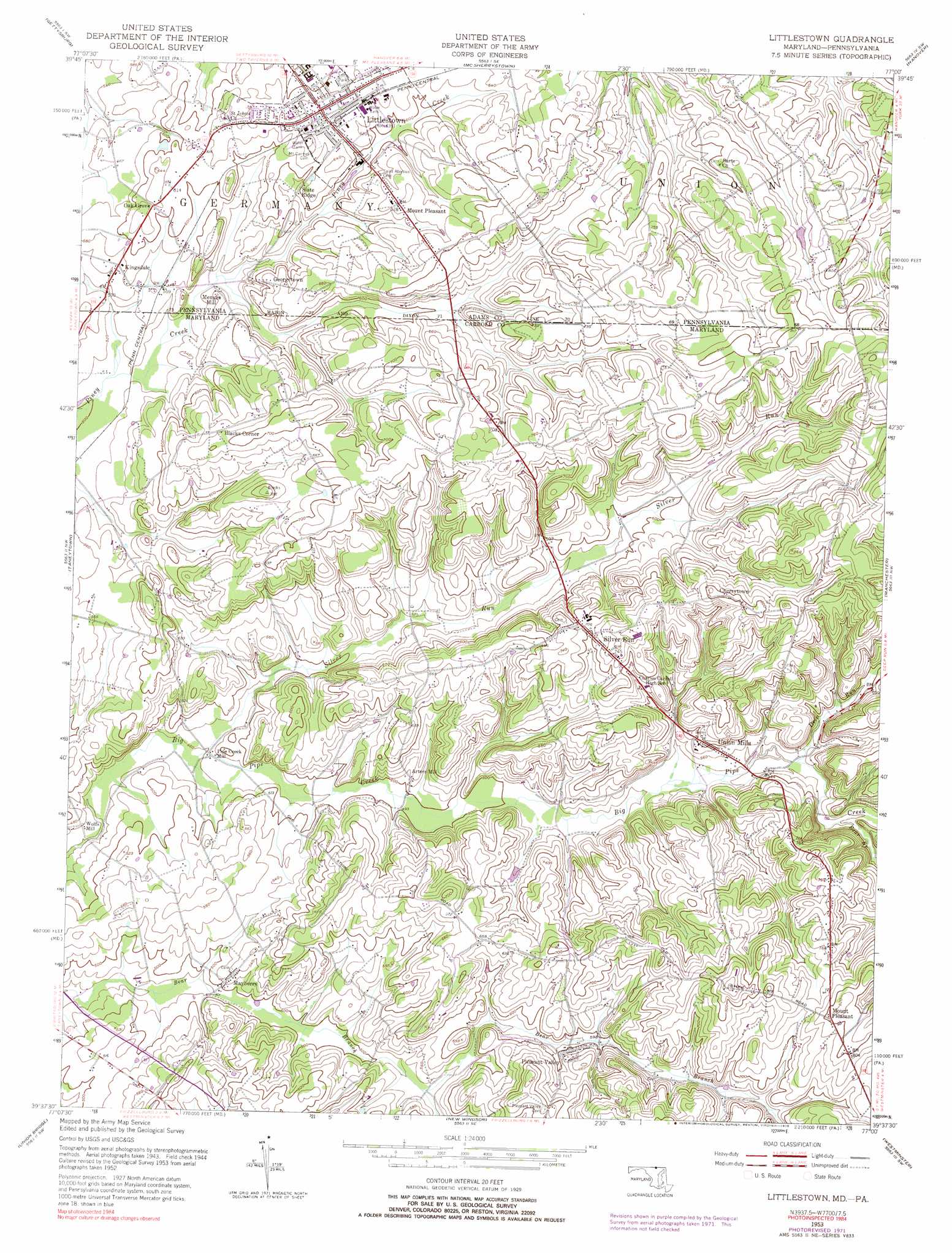
Littlestown Topo Map Maryland
To zoom in, hover over the map of Littlestown
USGS Topo Quad 39077f1 - 1:24,000 scale
| Topo Map Name: | Littlestown |
| USGS Topo Quad ID: | 39077f1 |
| Print Size: | ca. 21 1/4" wide x 27" high |
| Southeast Coordinates: | 39.625° N latitude / 77° W longitude |
| Map Center Coordinates: | 39.6875° N latitude / 77.0625° W longitude |
| U.S. States: | MD, PA |
| Filename: | o39077f1.jpg |
| Download Map JPG Image: | Littlestown topo map 1:24,000 scale |
| Map Type: | Topographic |
| Topo Series: | 7.5´ |
| Map Scale: | 1:24,000 |
| Source of Map Images: | United States Geological Survey (USGS) |
| Alternate Map Versions: |
Littlestown PA 1953, updated 1954 Download PDF Buy paper map Littlestown PA 1953, updated 1954 Download PDF Buy paper map Littlestown PA 1953, updated 1969 Download PDF Buy paper map Littlestown PA 1953, updated 1972 Download PDF Buy paper map Littlestown PA 1953, updated 1976 Download PDF Buy paper map Littlestown PA 1953, updated 1976 Download PDF Buy paper map Littlestown PA 2011 Download PDF Buy paper map Littlestown PA 2013 Download PDF Buy paper map Littlestown PA 2016 Download PDF Buy paper map |
1:24,000 Topo Quads surrounding Littlestown
Arendtsville |
Biglerville |
Hampton |
Abbottstown |
West York |
Fairfield |
Gettysburg |
Mcsherrystown |
Hanover |
Seven Valleys |
Emmitsburg |
Taneytown |
Littlestown |
Manchester |
Lineboro |
Woodsboro |
Union Bridge |
New Windsor |
Westminister |
Hampstead |
Walkersville |
Libertytown |
Winfield |
Finksburg |
Reisterstown |
> Back to 39077e1 at 1:100,000 scale
> Back to 39076a1 at 1:250,000 scale
> Back to U.S. Topo Maps home
Littlestown topo map: Gazetteer
Littlestown: Airports
Greer Airport elevation 147m 482′Kingsdale Air Park elevation 170m 557′
Mayberry Run Airport elevation 168m 551′
Littlestown: Dams
Black and Decker Manufacturing Company Dam elevation 181m 593′Littlestown: Parks
Carroll County Sports Complex elevation 239m 784′Union Mills Homestead Park elevation 166m 544′
Littlestown: Populated Places
Allandale elevation 176m 577′Arters Mill elevation 163m 534′
Arters Mill Estates elevation 172m 564′
Babylon Heights elevation 214m 702′
Bear Run elevation 178m 583′
Blacks Corner elevation 208m 682′
Breezewood Estates elevation 213m 698′
Cambridge Estates elevation 231m 757′
Cherrytown elevation 242m 793′
Colonial Hills elevation 190m 623′
Georgetown elevation 184m 603′
Greenfield elevation 252m 826′
Hahns Mill elevation 154m 505′
Hidden Oaks elevation 154m 505′
Hoot'N Hollow elevation 184m 603′
Huckleberry Bottom elevation 158m 518′
Humbert Schoolhouse Estates elevation 237m 777′
Kingsdale elevation 174m 570′
Larox Miracle Land elevation 173m 567′
Liebno Estates elevation 146m 479′
Linden Estates elevation 222m 728′
Little Acres elevation 173m 567′
Littlestown elevation 192m 629′
Locust Neck Heights elevation 190m 623′
Mayberry elevation 160m 524′
Mayberry Ridge elevation 177m 580′
Menges Mill elevation 171m 561′
Mount Pleasant elevation 205m 672′
Mount Pleasant elevation 232m 761′
Oak Grove elevation 184m 603′
Piney Creek (historical) elevation 153m 501′
Pipe Creek Mill elevation 145m 475′
Pleasant Valley elevation 186m 610′
Richardson Ridge elevation 165m 541′
Runnymeade Summit elevation 172m 564′
Shoemakers Lot elevation 211m 692′
Shour Valley elevation 200m 656′
Silver Hills elevation 218m 715′
Silver Run elevation 216m 708′
Silver Run Estates elevation 179m 587′
Slate Ridge elevation 176m 577′
Twin Lakes elevation 233m 764′
Union Mills elevation 178m 583′
Wolfs Mill elevation 139m 456′
Littlestown: Reservoirs
Black and Decker Manufacturing Company Reservoir elevation 181m 593′Littlestown: Springs
Koontz Spring elevation 165m 541′Littlestown: Streams
Bear Branch elevation 169m 554′Deep Run elevation 166m 544′
Silver Run elevation 140m 459′
Littlestown digital topo map on disk
Buy this Littlestown topo map showing relief, roads, GPS coordinates and other geographical features, as a high-resolution digital map file on DVD:
Atlantic Coast (NY, NJ, PA, DE, MD, VA, NC)
Buy digital topo maps: Atlantic Coast (NY, NJ, PA, DE, MD, VA, NC)
 map DVD")