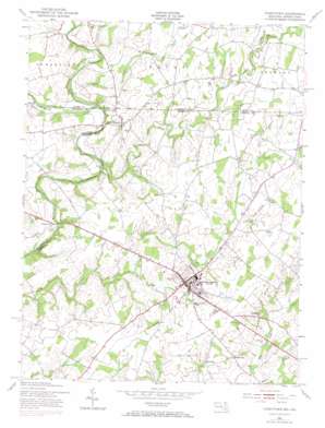
Taneytown Topo Map Maryland
To zoom in, hover over the map of Taneytown
USGS Topo Quad 39077f2 - 1:24,000 scale
| Topo Map Name: | Taneytown |
| USGS Topo Quad ID: | 39077f2 |
| Print Size: | ca. 21 1/4" wide x 27" high |
| Southeast Coordinates: | 39.625° N latitude / 77.125° W longitude |
| Map Center Coordinates: | 39.6875° N latitude / 77.1875° W longitude |
| U.S. States: | MD, PA |
| Filename: | o39077f2.jpg |
| Download Map JPG Image: | Taneytown topo map 1:24,000 scale |
| Map Type: | Topographic |
| Topo Series: | 7.5´ |
| Map Scale: | 1:24,000 |
| Source of Map Images: | United States Geological Survey (USGS) |
| Alternate Map Versions: |
Taneytown MD 1953 Download PDF Buy paper map Taneytown MD 1953, updated 1955 Download PDF Buy paper map Taneytown MD 1953, updated 1955 Download PDF Buy paper map Taneytown MD 1953, updated 1966 Download PDF Buy paper map Taneytown MD 1953, updated 1972 Download PDF Buy paper map Taneytown MD 2011 Download PDF Buy paper map Taneytown MD 2014 Download PDF Buy paper map Taneytown MD 2016 Download PDF Buy paper map |
1:24,000 Topo Quads surrounding Taneytown
> Back to 39077e1 at 1:100,000 scale
> Back to 39076a1 at 1:250,000 scale
> Back to U.S. Topo Maps home
Taneytown topo map: Gazetteer
Taneytown: Airports
Evapco Heliport elevation 145m 475′Locust Row Airport (historical) elevation 169m 554′
Taneytown Airport (historical) elevation 156m 511′
Taneytown: Bridges
Bullfrog Road Bridge elevation 106m 347′Taneytown: Dams
Starners Dam elevation 108m 354′Taneytown: Parks
Big Pipe Creek Park elevation 129m 423′Carroll County Fairgrounds (historical) elevation 171m 561′
Roberts Mill Park elevation 171m 561′
Roth Recreational Park elevation 160m 524′
Taneytown Historic District elevation 161m 528′
Taneytown Memorial Park elevation 145m 475′
Taneytown: Populated Places
Bridgeport elevation 114m 374′Brown Heights elevation 139m 456′
Brownsville elevation 151m 495′
Cloverberry elevation 159m 521′
Copperfield elevation 159m 521′
Copperville elevation 153m 501′
Crabster (historical) elevation 157m 515′
Cunningham Acres elevation 154m 505′
Eleven Meadows elevation 166m 544′
Fairground Village elevation 167m 547′
Galt elevation 161m 528′
Green Meadows elevation 159m 521′
Greenland Manor elevation 155m 508′
Harney elevation 153m 501′
Herring Estates elevation 161m 528′
Hyser Estates elevation 143m 469′
Longs Mountain View elevation 150m 492′
Longville elevation 165m 541′
Mairs Mill elevation 116m 380′
Meadow Brook elevation 154m 505′
Ottersdale elevation 155m 508′
Palmer (historical) elevation 115m 377′
Rising Sun elevation 157m 515′
Roberts Mill Run elevation 153m 501′
Ruthed Estates elevation 159m 521′
Stonemyer Manor elevation 136m 446′
Stumptown elevation 149m 488′
Taneytown elevation 154m 505′
Tranquility Estates elevation 133m 436′
Trevanion Terrace elevation 158m 518′
Walnut Grove elevation 164m 538′
Wheatfields elevation 165m 541′
White Birch Estates elevation 167m 547′
Taneytown: Post Offices
Taneytown Post Office elevation 156m 511′Taneytown: Streams
Alloway Creek elevation 109m 357′Alloway Creek elevation 109m 357′
Bear Branch elevation 126m 413′
Cattail Branch elevation 103m 337′
Lousy Run elevation 114m 374′
Marsh Creek elevation 115m 377′
Meadow Branch Big Pipe Creek elevation 125m 410′
Plum Creek elevation 151m 495′
Rock Creek elevation 115m 377′
Taneytown digital topo map on disk
Buy this Taneytown topo map showing relief, roads, GPS coordinates and other geographical features, as a high-resolution digital map file on DVD:
Atlantic Coast (NY, NJ, PA, DE, MD, VA, NC)
Buy digital topo maps: Atlantic Coast (NY, NJ, PA, DE, MD, VA, NC)


