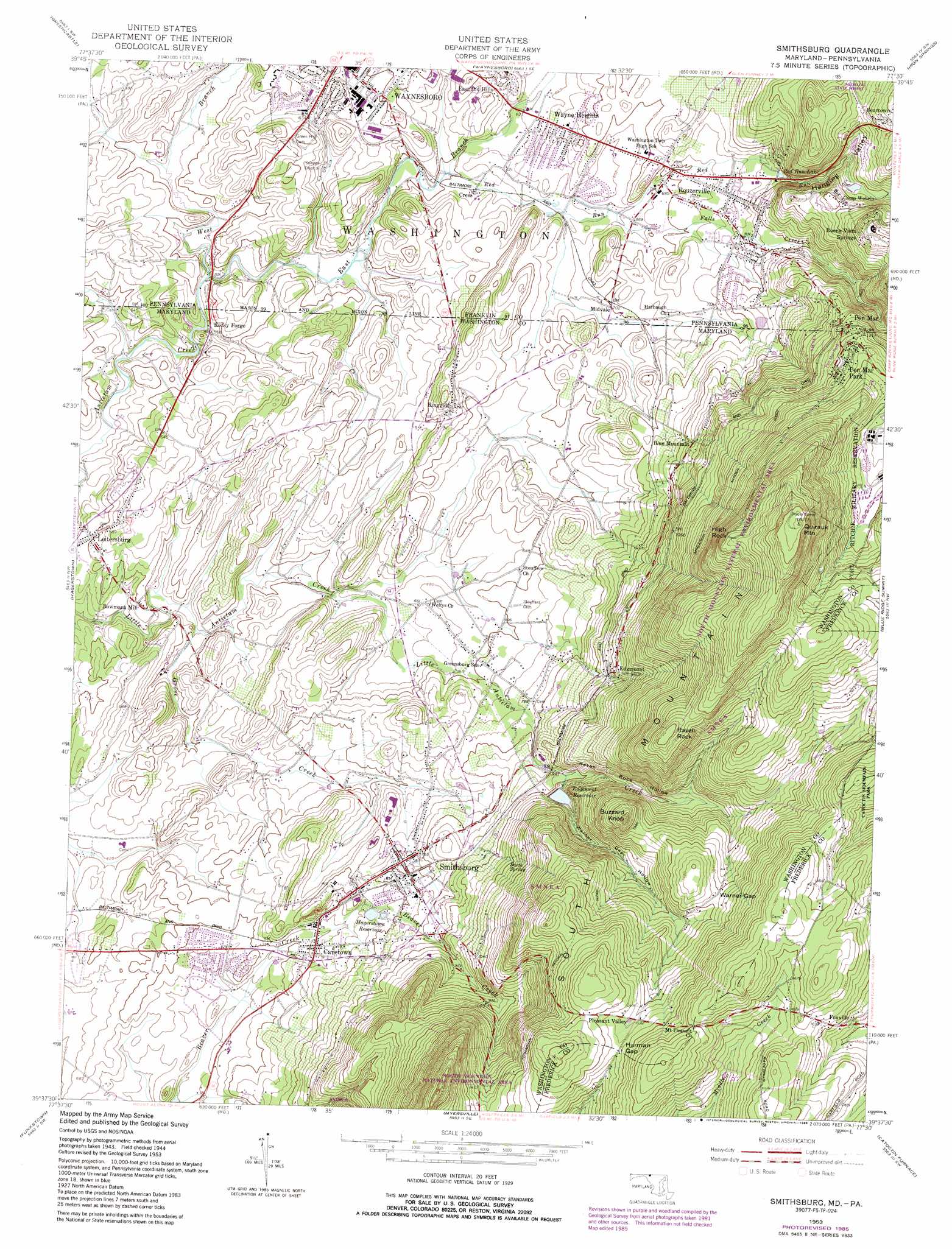
Smithsburg Topo Map Maryland
To zoom in, hover over the map of Smithsburg
USGS Topo Quad 39077f5 - 1:24,000 scale
| Topo Map Name: | Smithsburg |
| USGS Topo Quad ID: | 39077f5 |
| Print Size: | ca. 21 1/4" wide x 27" high |
| Southeast Coordinates: | 39.625° N latitude / 77.5° W longitude |
| Map Center Coordinates: | 39.6875° N latitude / 77.5625° W longitude |
| U.S. States: | MD, PA |
| Filename: | o39077f5.jpg |
| Download Map JPG Image: | Smithsburg topo map 1:24,000 scale |
| Map Type: | Topographic |
| Topo Series: | 7.5´ |
| Map Scale: | 1:24,000 |
| Source of Map Images: | United States Geological Survey (USGS) |
| Alternate Map Versions: |
Smithsburg MD 1953, updated 1955 Download PDF Buy paper map Smithsburg MD 1953, updated 1955 Download PDF Buy paper map Smithsburg MD 1953, updated 1965 Download PDF Buy paper map Smithsburg MD 1953, updated 1972 Download PDF Buy paper map Smithsburg MD 1953, updated 1986 Download PDF Buy paper map Smithsburg MD 1994, updated 1999 Download PDF Buy paper map Smithsburg MD 2011 Download PDF Buy paper map Smithsburg MD 2014 Download PDF Buy paper map Smithsburg MD 2016 Download PDF Buy paper map |
1:24,000 Topo Quads surrounding Smithsburg
Saint Thomas |
Chambersburg |
Scotland |
Caledonia Park |
Arendtsville |
Williamson |
Greencastle |
Waynesboro |
Iron Springs |
Fairfield |
Mason-Dixon |
Hagerstown |
Smithsburg |
Blue Ridge Summit |
Emmitsburg |
Williamsport |
Funkstown |
Myersville |
Catoctin Furnace |
Woodsboro |
Shepherdstown |
Keedysville |
Middletown |
Frederick |
Walkersville |
> Back to 39077e1 at 1:100,000 scale
> Back to 39076a1 at 1:250,000 scale
> Back to U.S. Topo Maps home
Smithsburg topo map: Gazetteer
Smithsburg: Dams
Comet Lake Dam elevation 300m 984′Mdnoname1 Dam elevation 268m 879′
Warners Gap Hollow Dam elevation 327m 1072′
Wohelo Lake Dam elevation 286m 938′
Smithsburg: Gaps
Harman Gap elevation 479m 1571′Warner Gap elevation 431m 1414′
Smithsburg: Parks
Pen Mar Park elevation 390m 1279′Smithsburg: Populated Places
Beartown elevation 351m 1151′Beaverbrook elevation 201m 659′
Blue Mountain elevation 286m 938′
Blueberry Heights elevation 266m 872′
Bluegrass Estates elevation 184m 603′
Bowmans Mill elevation 182m 597′
Buena Vista Springs elevation 406m 1332′
Cavetown elevation 222m 728′
Country Squire Estates elevation 196m 643′
Cress elevation 187m 613′
Eastland Hills elevation 212m 695′
Edgemont elevation 296m 971′
Greensburg elevation 212m 695′
Greenvale Village elevation 203m 666′
Havenwood Hills elevation 213m 698′
Hill Village elevation 171m 561′
Holiday Acres elevation 210m 688′
Holiday Farms elevation 214m 702′
Hopkins Ridge elevation 499m 1637′
Leitersburg elevation 181m 593′
Midvale elevation 215m 705′
Orchard Estates elevation 201m 659′
Pen Mar elevation 377m 1236′
Pen Mar Park elevation 403m 1322′
Pleasant Valley elevation 467m 1532′
Ringgold elevation 232m 761′
Rocky Forge elevation 171m 561′
Rouzerville elevation 209m 685′
Shockeys (historical) elevation 241m 790′
Smithsburg elevation 235m 770′
Waterloo elevation 238m 780′
Wayne Heights elevation 194m 636′
Smithsburg: Post Offices
Buena Vista Spring Post Office (historical) elevation 406m 1332′Cavetown Post Office elevation 224m 734′
Pen Mar Post Office (historical) elevation 377m 1236′
Smithsburg Post Office elevation 242m 793′
Smithsburg: Reservoirs
Comet Lake elevation 300m 984′Edgemont Reservoir elevation 274m 898′
Edgemont Reservoir elevation 327m 1072′
Hagerstown Reservoir elevation 239m 784′
Red Run Lake elevation 236m 774′
Smithsburg Reservoir elevation 268m 879′
Smithsburg: Springs
Barth Spring elevation 304m 997′Glen Afton Spring elevation 364m 1194′
Smithsburg: Streams
East Branch Antietam Creek elevation 175m 574′Edgemont Creek elevation 351m 1151′
Falls Creek elevation 200m 656′
Grove Creek elevation 169m 554′
Red Run elevation 182m 597′
West Branch Antietam Creek elevation 175m 574′
Smithsburg: Summits
Buzzard Knob elevation 475m 1558′High Rock elevation 559m 1833′
Quirauk Mountain elevation 654m 2145′
Raven Rock elevation 515m 1689′
Smithsburg: Valleys
Hanging Valley elevation 250m 820′Raven Rock Hollow elevation 254m 833′
Warner Gap Hollow elevation 267m 875′
Smithsburg digital topo map on disk
Buy this Smithsburg topo map showing relief, roads, GPS coordinates and other geographical features, as a high-resolution digital map file on DVD:
Atlantic Coast (NY, NJ, PA, DE, MD, VA, NC)
Buy digital topo maps: Atlantic Coast (NY, NJ, PA, DE, MD, VA, NC)
 map DVD")