Hagerstown Topo Map Maryland
To zoom in, hover over the map of Hagerstown
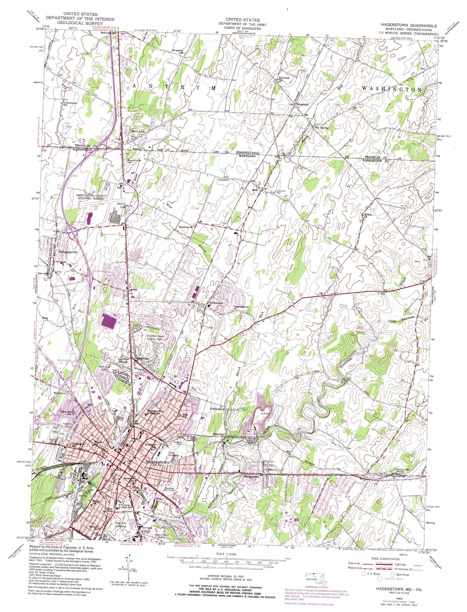
USGS Topo Quad 39077f6 - 1:24,000 scale
| Topo Map Name: | Hagerstown |
| USGS Topo Quad ID: | 39077f6 |
| Print Size: | ca. 21 1/4" wide x 27" high |
| Southeast Coordinates: | 39.625° N latitude / 77.625° W longitude |
| Map Center Coordinates: | 39.6875° N latitude / 77.6875° W longitude |
| U.S. States: | MD, PA |
| Filename: | o39077f6.jpg |
| Download Map JPG Image: | Hagerstown topo map 1:24,000 scale |
| Map Type: | Topographic |
| Topo Series: | 7.5´ |
| Map Scale: | 1:24,000 |
| Source of Map Images: | United States Geological Survey (USGS) |
| Alternate Map Versions: |
Hagerstown MD 1953, updated 1954 Download PDF Buy paper map Hagerstown MD 1953, updated 1965 Download PDF Buy paper map Hagerstown MD 1953, updated 1972 Download PDF Buy paper map Hagerstown MD 1953, updated 1986 Download PDF Buy paper map Hagerstown MD 1999, updated 2002 Download PDF Buy paper map Hagerstown MD 2011 Download PDF Buy paper map Hagerstown MD 2014 Download PDF Buy paper map Hagerstown MD 2016 Download PDF Buy paper map |
1:24,000 Topo Quads surrounding Hagerstown
Mcconnellsburg |
Saint Thomas |
Chambersburg |
Scotland |
Caledonia Park |
Mercersburg |
Williamson |
Greencastle |
Waynesboro |
Iron Springs |
Clear Spring |
Mason-Dixon |
Hagerstown |
Smithsburg |
Blue Ridge Summit |
Hedgesville |
Williamsport |
Funkstown |
Myersville |
Catoctin Furnace |
Martinsburg |
Shepherdstown |
Keedysville |
Middletown |
Frederick |
> Back to 39077e1 at 1:100,000 scale
> Back to 39076a1 at 1:250,000 scale
> Back to U.S. Topo Maps home
Hagerstown topo map: Gazetteer
Hagerstown: Airports
Craig Company Heliport elevation 194m 636′Washington County Hospital Heliport elevation 157m 515′
Washington County Regional Airport elevation 208m 682′
Hagerstown: Crossings
Interchange 10 elevation 201m 659′Interchange 6 elevation 180m 590′
Interchange 7 elevation 189m 620′
Interchange 8 elevation 195m 639′
Interchange 9 elevation 201m 659′
Hagerstown: Parks
Funkhouser Park elevation 152m 498′Hager Park elevation 157m 515′
Hagerstown City Park Historic District elevation 175m 574′
Hagerstown Commercial Core Historic District elevation 166m 544′
Hellane Park elevation 196m 643′
Lehmans Mill Historic District elevation 177m 580′
Municipal Stadium elevation 154m 505′
Oak Hill Historic District elevation 177m 580′
Pangborn Park elevation 159m 521′
Potomac-Broadway Historic District elevation 177m 580′
Potterfield Park elevation 152m 498′
Roy H Reed Park elevation 170m 557′
South Prospect Street Historic District elevation 177m 580′
Washington County Fairgrounds elevation 165m 541′
Wheaton Park elevation 173m 567′
Hagerstown: Populated Places
Bridgeport elevation 168m 551′Carroll Heights elevation 188m 616′
Cedar Hills elevation 159m 521′
Chewsville elevation 194m 636′
Clearview elevation 191m 626′
Colonial Park elevation 151m 495′
Countryside elevation 189m 620′
Fairgreen Acres elevation 192m 629′
Fiddlesburg elevation 154m 505′
Forest Hills elevation 193m 633′
Fortney Mobile Home Park elevation 200m 656′
Fountain Head elevation 187m 613′
Fountain Head Heights elevation 178m 583′
Frederick Manor elevation 156m 511′
Good Acres elevation 189m 620′
Green Hill Acres elevation 171m 561′
Hagerstown elevation 164m 538′
Hamilton Park elevation 188m 616′
Hunter Hill elevation 172m 564′
Hyde Park elevation 183m 600′
Jefferson Heights elevation 170m 557′
Long Meadow elevation 198m 649′
Lurose Estates elevation 177m 580′
Maugansville elevation 189m 620′
Miller Chapel elevation 194m 636′
Northaven Mobile Home Park elevation 194m 636′
Northridge Manor elevation 194m 636′
Orchard Hills elevation 197m 646′
Paramount elevation 189m 620′
Paramount Manor elevation 178m 583′
Potomac Heights elevation 168m 551′
Potomac Manor elevation 165m 541′
Reid elevation 177m 580′
Robinwood elevation 171m 561′
Security elevation 154m 505′
Spring Valley elevation 179m 587′
State Line elevation 214m 702′
Sunset Acres elevation 149m 488′
Sycamore Heights elevation 177m 580′
Terrace Hills elevation 177m 580′
Trengail Manor elevation 175m 574′
Weller Farm elevation 166m 544′
Winding Creek South elevation 176m 577′
Wingerton elevation 193m 633′
Wood Point elevation 192m 629′
Woodlands elevation 195m 639′
Hagerstown: Post Offices
Chewsville Post Office elevation 193m 633′Hagerstown Post Office elevation 168m 551′
Maugansville Post Office elevation 189m 620′
Security Post Office (historical) elevation 152m 498′
Hagerstown: Springs
Museum Spring elevation 166m 544′Hagerstown: Streams
Hamilton Run elevation 145m 475′Little Antietam Creek elevation 154m 505′
Marsh Run elevation 146m 479′
Marsh Run elevation 147m 482′
West Branch Marsh Run elevation 170m 557′
Hagerstown digital topo map on disk
Buy this Hagerstown topo map showing relief, roads, GPS coordinates and other geographical features, as a high-resolution digital map file on DVD:
Atlantic Coast (NY, NJ, PA, DE, MD, VA, NC)
Buy digital topo maps: Atlantic Coast (NY, NJ, PA, DE, MD, VA, NC)
 map DVD")