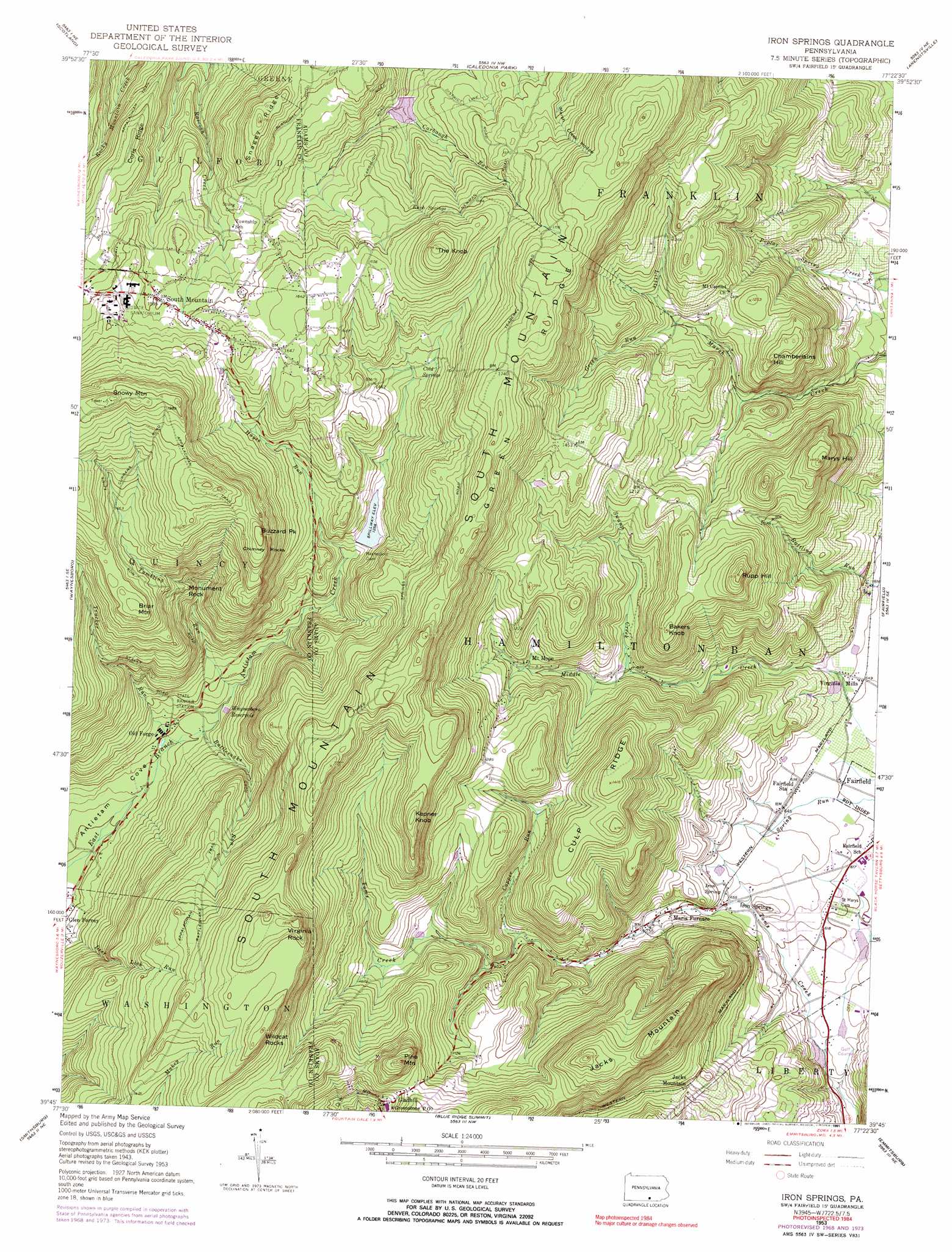
Iron Springs Topo Map Pennsylvania
To zoom in, hover over the map of Iron Springs
USGS Topo Quad 39077g4 - 1:24,000 scale
| Topo Map Name: | Iron Springs |
| USGS Topo Quad ID: | 39077g4 |
| Print Size: | ca. 21 1/4" wide x 27" high |
| Southeast Coordinates: | 39.75° N latitude / 77.375° W longitude |
| Map Center Coordinates: | 39.8125° N latitude / 77.4375° W longitude |
| U.S. State: | PA |
| Filename: | o39077g4.jpg |
| Download Map JPG Image: | Iron Springs topo map 1:24,000 scale |
| Map Type: | Topographic |
| Topo Series: | 7.5´ |
| Map Scale: | 1:24,000 |
| Source of Map Images: | United States Geological Survey (USGS) |
| Alternate Map Versions: |
Iron Springs PA 1953, updated 1954 Download PDF Buy paper map Iron Springs PA 1953, updated 1967 Download PDF Buy paper map Iron Springs PA 1953, updated 1969 Download PDF Buy paper map Iron Springs PA 1953, updated 1974 Download PDF Buy paper map Iron Springs PA 1953, updated 1991 Download PDF Buy paper map Iron Springs PA 1990, updated 1995 Download PDF Buy paper map Iron Springs PA 1990, updated 1995 Download PDF Buy paper map Iron Springs PA 2010 Download PDF Buy paper map Iron Springs PA 2013 Download PDF Buy paper map Iron Springs PA 2016 Download PDF Buy paper map |
1:24,000 Topo Quads surrounding Iron Springs
Roxbury |
Shippensburg |
Walnut Bottom |
Dickinson |
Mount Holly Springs |
Chambersburg |
Scotland |
Caledonia Park |
Arendtsville |
Biglerville |
Greencastle |
Waynesboro |
Iron Springs |
Fairfield |
Gettysburg |
Hagerstown |
Smithsburg |
Blue Ridge Summit |
Emmitsburg |
Taneytown |
Funkstown |
Myersville |
Catoctin Furnace |
Woodsboro |
Union Bridge |
> Back to 39077e1 at 1:100,000 scale
> Back to 39076a1 at 1:250,000 scale
> Back to U.S. Topo Maps home
Iron Springs topo map: Gazetteer
Iron Springs: Airports
Roth Private Airstrip elevation 198m 649′Iron Springs: Areas
Devils Racecourse elevation 455m 1492′Old Forge Picnic Area elevation 272m 892′
Iron Springs: Dams
Antietam Dam elevation 381m 1250′Carbaugh Run Dam elevation 400m 1312′
Waynesboro Dam elevation 381m 1250′
Iron Springs: Lakes
Charnita Lake elevation 165m 541′Iron Springs: Pillars
Marys Rock elevation 435m 1427′Raven Rock elevation 305m 1000′
Iron Springs: Populated Places
Gladhill elevation 378m 1240′Iron Springs elevation 198m 649′
Jacks Mountain elevation 295m 967′
Maria Furnace elevation 213m 698′
Marshall elevation 203m 666′
Mount Hope elevation 313m 1026′
Old Forge elevation 272m 892′
Ram elevation 502m 1646′
South Mountain elevation 486m 1594′
Tartown elevation 525m 1722′
Virginia Mills elevation 195m 639′
Iron Springs: Post Offices
Greenstone Post Office elevation 378m 1240′Iron Springs: Reservoirs
Caledonia Lake elevation 400m 1312′Carbaugh Reservoir elevation 397m 1302′
Waynesboro Reservoir elevation 303m 994′
Iron Springs: Ridges
Corls Ridge elevation 445m 1459′Culp Ridge elevation 414m 1358′
Green Ridge elevation 530m 1738′
Iron Springs: Springs
Cold Springs elevation 442m 1450′Iron Spring elevation 200m 656′
Knob Springs elevation 491m 1610′
Poplar Spring elevation 340m 1115′
Iron Springs: Streams
Copper Run elevation 179m 587′Green Run elevation 331m 1085′
Hayes Run elevation 361m 1184′
Rattlesnake Run elevation 282m 925′
Saw Mill Run elevation 404m 1325′
Swamp Creek elevation 270m 885′
Trucker Run elevation 267m 875′
Tumbling Run elevation 293m 961′
Iron Springs: Summits
Bakers Knob elevation 405m 1328′Briar Mountain elevation 533m 1748′
Buzzard Park elevation 564m 1850′
Chamberlains Hill elevation 403m 1322′
Chimney Rocks elevation 535m 1755′
Jacks Mountain elevation 470m 1541′
Kepner Knob elevation 512m 1679′
Marys Hill elevation 418m 1371′
McCarrys Knob elevation 511m 1676′
Monument Rock elevation 425m 1394′
Pine Mountain elevation 480m 1574′
Rupp Hill elevation 452m 1482′
Snowy Mountain elevation 629m 2063′
The Knob elevation 573m 1879′
Virginia Rock elevation 545m 1788′
Wildcat Rocks elevation 533m 1748′
Iron Springs: Trails
Green Ridge Trail elevation 554m 1817′Iron Springs digital topo map on disk
Buy this Iron Springs topo map showing relief, roads, GPS coordinates and other geographical features, as a high-resolution digital map file on DVD:
Atlantic Coast (NY, NJ, PA, DE, MD, VA, NC)
Buy digital topo maps: Atlantic Coast (NY, NJ, PA, DE, MD, VA, NC)
 map DVD")