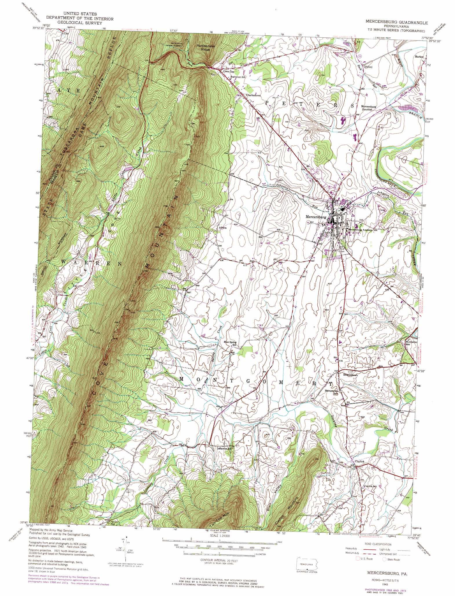
Mercersburg Topo Map Pennsylvania
To zoom in, hover over the map of Mercersburg
USGS Topo Quad 39077g8 - 1:24,000 scale
| Topo Map Name: | Mercersburg |
| USGS Topo Quad ID: | 39077g8 |
| Print Size: | ca. 21 1/4" wide x 27" high |
| Southeast Coordinates: | 39.75° N latitude / 77.875° W longitude |
| Map Center Coordinates: | 39.8125° N latitude / 77.9375° W longitude |
| U.S. State: | PA |
| Filename: | o39077g8.jpg |
| Download Map JPG Image: | Mercersburg topo map 1:24,000 scale |
| Map Type: | Topographic |
| Topo Series: | 7.5´ |
| Map Scale: | 1:24,000 |
| Source of Map Images: | United States Geological Survey (USGS) |
| Alternate Map Versions: |
Mercersburg PA 1943, updated 1952 Download PDF Buy paper map Mercersburg PA 1943, updated 1952 Download PDF Buy paper map Mercersburg PA 1943, updated 1965 Download PDF Buy paper map Mercersburg PA 1943, updated 1969 Download PDF Buy paper map Mercersburg PA 1943, updated 1974 Download PDF Buy paper map Mercersburg PA 1943, updated 1984 Download PDF Buy paper map Mercersburg PA 1990, updated 1995 Download PDF Buy paper map Mercersburg PA 2010 Download PDF Buy paper map Mercersburg PA 2013 Download PDF Buy paper map Mercersburg PA 2016 Download PDF Buy paper map |
1:24,000 Topo Quads surrounding Mercersburg
Wells Tannery |
Hustontown |
Burnt Cabins |
Fannettsburg |
Roxbury |
Breezewood |
Meadow Grounds |
Mcconnellsburg |
Saint Thomas |
Chambersburg |
Needmore |
Big Cove Tannery |
Mercersburg |
Williamson |
Greencastle |
Hancock |
Cherry Run |
Clear Spring |
Mason-Dixon |
Hagerstown |
Stotlers Crossroads |
Big Pool |
Hedgesville |
Williamsport |
Funkstown |
> Back to 39077e1 at 1:100,000 scale
> Back to 39076a1 at 1:250,000 scale
> Back to U.S. Topo Maps home
Mercersburg topo map: Gazetteer
Mercersburg: Dams
Buck Run Dam elevation 259m 849′Mercersburg: Parks
Buchanan's Birthplace State Park elevation 278m 912′Mercersburg: Populated Places
Charlestown elevation 232m 761′Claylick elevation 159m 521′
Cove Gap elevation 237m 777′
Dickey elevation 171m 561′
Lenwood Heights elevation 186m 610′
Mercersburg elevation 173m 567′
Mercersburg Junction elevation 165m 541′
Shimpstown elevation 183m 600′
Mercersburg: Ridges
Cove Mountain elevation 509m 1669′Rattlesnake Ridge elevation 474m 1555′
Mercersburg: Streams
Blue Spring Creek elevation 168m 551′Buck Run elevation 162m 531′
Johnston Run elevation 151m 495′
Mercersburg: Summits
Claylick Mountain elevation 312m 1023′Mercersburg: Valleys
Little Cove Valley elevation 189m 620′Mercersburg digital topo map on disk
Buy this Mercersburg topo map showing relief, roads, GPS coordinates and other geographical features, as a high-resolution digital map file on DVD:
Atlantic Coast (NY, NJ, PA, DE, MD, VA, NC)
Buy digital topo maps: Atlantic Coast (NY, NJ, PA, DE, MD, VA, NC)
 map DVD")