Hayfield Topo Map Virginia
To zoom in, hover over the map of Hayfield
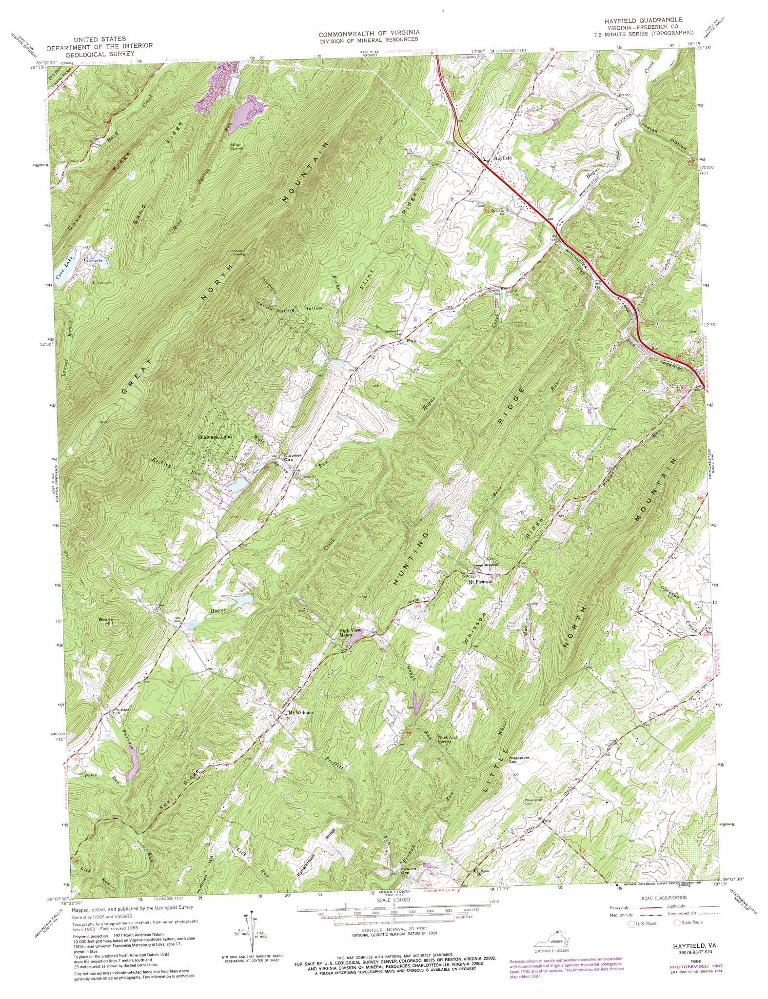
USGS Topo Quad 39078b3 - 1:24,000 scale
| Topo Map Name: | Hayfield |
| USGS Topo Quad ID: | 39078b3 |
| Print Size: | ca. 21 1/4" wide x 27" high |
| Southeast Coordinates: | 39.125° N latitude / 78.25° W longitude |
| Map Center Coordinates: | 39.1875° N latitude / 78.3125° W longitude |
| U.S. State: | VA |
| Filename: | o39078b3.jpg |
| Download Map JPG Image: | Hayfield topo map 1:24,000 scale |
| Map Type: | Topographic |
| Topo Series: | 7.5´ |
| Map Scale: | 1:24,000 |
| Source of Map Images: | United States Geological Survey (USGS) |
| Alternate Map Versions: |
Hayfield VA 1965, updated 1968 Download PDF Buy paper map Hayfield VA 1965, updated 1973 Download PDF Buy paper map Hayfield VA 1965, updated 1987 Download PDF Buy paper map Hayfield VA 2010 Download PDF Buy paper map Hayfield VA 2013 Download PDF Buy paper map Hayfield VA 2016 Download PDF Buy paper map |
1:24,000 Topo Quads surrounding Hayfield
Levels |
Largent |
Ridge |
Glengary |
Tablers Station |
Hanging Rock |
Capon Bridge |
Gore |
White Hall |
Inwood |
Yellow Spring |
Capon Springs |
Hayfield |
Winchester |
Stephenson |
Wardensville |
Mountain Falls |
Middletown |
Stephens City |
Boyce |
Woodstock |
Toms Brook |
Strasburg |
Front Royal |
Linden |
> Back to 39078a1 at 1:100,000 scale
> Back to 39078a1 at 1:250,000 scale
> Back to U.S. Topo Maps home
Hayfield topo map: Gazetteer
Hayfield: Dams
Cove Dam elevation 347m 1138′Cove Number Two Dam elevation 364m 1194′
Crystal Dam elevation 291m 954′
High View Manor Dam elevation 315m 1033′
Kelchners Dam elevation 268m 879′
Lehmans Dam elevation 289m 948′
Meadowlake Dam elevation 282m 925′
Unimin Fresh Water Dam elevation 277m 908′
Unimin Tailings Dam elevation 320m 1049′
Hayfield: Gaps
Clowser Gap elevation 264m 866′Fawcett Gap elevation 244m 800′
Wisecarver Gap elevation 274m 898′
Hayfield: Populated Places
Bloom (historical) elevation 282m 925′Cabaniss elevation 339m 1112′
Devland Estates elevation 223m 731′
Hayfield elevation 235m 770′
High View Manor elevation 334m 1095′
Hogue Creek Estates elevation 241m 790′
Indian Hollow elevation 207m 679′
Indian Lake elevation 234m 767′
Layside Estates elevation 297m 974′
Lincoln Estates elevation 302m 990′
McQuire elevation 206m 675′
Mount Pleasant elevation 308m 1010′
Mount Williams elevation 341m 1118′
Paxton Hills elevation 334m 1095′
Rosenberger elevation 250m 820′
Shawnee Land elevation 336m 1102′
Zeiger elevation 290m 951′
Hayfield: Post Offices
Hayfield Post Office elevation 229m 751′Hayfield: Reservoirs
Beaver Lake elevation 278m 912′Cherokee Lake elevation 292m 958′
Cove Lake elevation 347m 1138′
Cove Lake elevation 348m 1141′
Crystal Lake elevation 291m 954′
Emerald Lake elevation 291m 954′
Fresh Water Pond elevation 277m 908′
High View Manor Lake elevation 315m 1033′
Lake Leckszas elevation 364m 1194′
Lehmans Pond elevation 289m 948′
Meadow Lake elevation 282m 925′
Peacefull Valley Lake elevation 268m 879′
Rainbow Lake elevation 279m 915′
Swan Lake elevation 251m 823′
Tailings Pond elevation 320m 1049′
Hayfield: Ridges
Cove Ridge elevation 420m 1377′Flint Ridge elevation 303m 994′
Fox Ridge elevation 304m 997′
Hunting Ridge elevation 287m 941′
Sand Ridge elevation 434m 1423′
Whisson Ridge elevation 342m 1122′
Hayfield: Springs
Buck Lick Spring elevation 269m 882′Mine Spring elevation 286m 938′
Hayfield: Streams
Bear Run elevation 213m 698′Bucher Run elevation 210m 688′
Gap Run elevation 205m 672′
Gough Run elevation 254m 833′
Keckley Run elevation 260m 853′
Lick Run elevation 236m 774′
Pifer Run elevation 255m 836′
Poplar Run elevation 247m 810′
Preffitt Run elevation 240m 787′
White Run elevation 254m 833′
Wolf Spring Run elevation 228m 748′
Hayfield: Summits
Beans Hill elevation 401m 1315′Hayfield: Valleys
Clapboard Hollow elevation 304m 997′Dick Hollow elevation 246m 807′
Indian Hollow elevation 197m 646′
Yellow Spring Hollow elevation 263m 862′
Hayfield digital topo map on disk
Buy this Hayfield topo map showing relief, roads, GPS coordinates and other geographical features, as a high-resolution digital map file on DVD:
 map DVD")