Inwood Topo Map West Virginia
To zoom in, hover over the map of Inwood
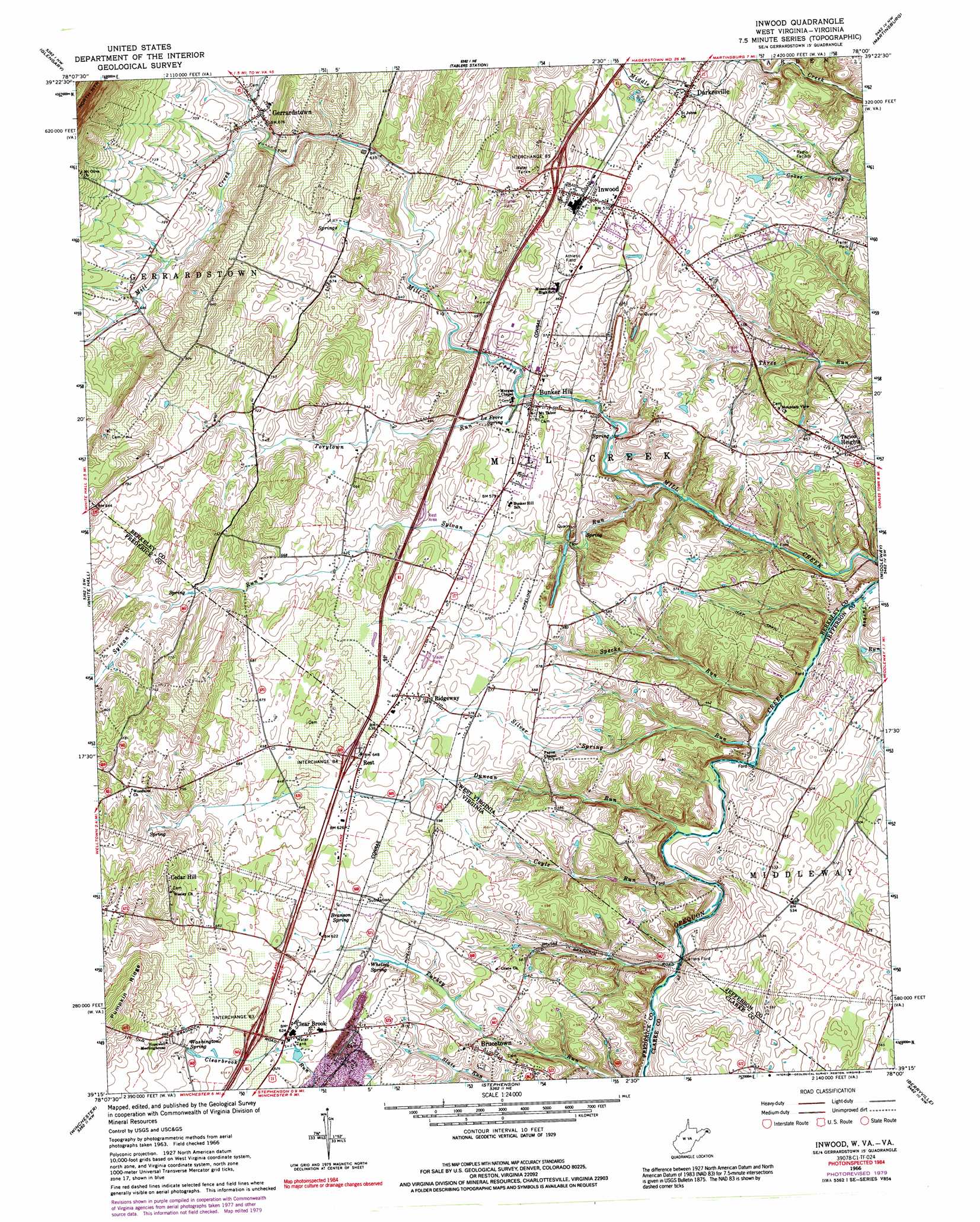
USGS Topo Quad 39078c1 - 1:24,000 scale
| Topo Map Name: | Inwood |
| USGS Topo Quad ID: | 39078c1 |
| Print Size: | ca. 21 1/4" wide x 27" high |
| Southeast Coordinates: | 39.25° N latitude / 78° W longitude |
| Map Center Coordinates: | 39.3125° N latitude / 78.0625° W longitude |
| U.S. States: | WV, VA |
| Filename: | o39078c1.jpg |
| Download Map JPG Image: | Inwood topo map 1:24,000 scale |
| Map Type: | Topographic |
| Topo Series: | 7.5´ |
| Map Scale: | 1:24,000 |
| Source of Map Images: | United States Geological Survey (USGS) |
| Alternate Map Versions: |
Inwood WV 1966, updated 1967 Download PDF Buy paper map Inwood WV 1966, updated 1975 Download PDF Buy paper map Inwood WV 1966, updated 1979 Download PDF Buy paper map Inwood WV 1966, updated 1992 Download PDF Buy paper map Inwood WV 2011 Download PDF Buy paper map Inwood WV 2014 Download PDF Buy paper map Inwood WV 2016 Download PDF Buy paper map |
1:24,000 Topo Quads surrounding Inwood
Great Cacapon |
Stotlers Crossroads |
Big Pool |
Hedgesville |
Williamsport |
Ridge |
Glengary |
Tablers Station |
Martinsburg |
Shepherdstown |
Gore |
White Hall |
Inwood |
Middleway |
Charles Town |
Hayfield |
Winchester |
Stephenson |
Berryville |
Round Hill |
Middletown |
Stephens City |
Boyce |
Ashby Gap |
Bluemont |
> Back to 39078a1 at 1:100,000 scale
> Back to 39078a1 at 1:250,000 scale
> Back to U.S. Topo Maps home
Inwood topo map: Gazetteer
Inwood: Crossings
Carter Ford elevation 138m 452′Interchange 321 elevation 194m 636′
Interchange 323 elevation 195m 639′
Interchange 5 elevation 183m 600′
Shaulls Ford elevation 131m 429′
Inwood: Parks
Bunker Hill Historic District elevation 171m 561′Clearbrook Park elevation 187m 613′
Darkesville Historic District elevation 163m 534′
Mill Creek Historic District elevation 166m 544′
Inwood: Populated Places
Apple View Estates elevation 209m 685′Brucetown elevation 181m 593′
Bunker Hill elevation 173m 567′
Cedar Hill elevation 238m 780′
Clear Brook elevation 189m 620′
Darkesville elevation 162m 531′
Gerrardstown elevation 207m 679′
Gordondale elevation 208m 682′
Inwood elevation 173m 567′
Peach Orchard Inn Farms elevation 171m 561′
Rest elevation 196m 643′
Ridgeway elevation 180m 590′
Tarico Heights elevation 174m 570′
Inwood: Post Offices
Brucetown Post Office elevation 181m 593′Bunker Hill Post Office elevation 171m 561′
Clear Brook Post Office elevation 188m 616′
Gerrardstown Post Office elevation 207m 679′
Inwood Post Office elevation 174m 570′
Inwood: Ridges
Pumpkin Ridge elevation 255m 836′Inwood: Springs
Boiling Springs elevation 148m 485′Boyer Farm Spring elevation 160m 524′
Branson Spring elevation 185m 606′
Carter Spring elevation 200m 656′
Charles Crim Spring elevation 151m 495′
Cool Spring elevation 227m 744′
Douglas Miller Farm Spring elevation 202m 662′
Grey Spring elevation 198m 649′
Gum Spring elevation 168m 551′
Lee Whitacore Farm Spring elevation 185m 606′
LeFevre Spring elevation 169m 554′
Lemons Spring elevation 149m 488′
Opequon Spring elevation 140m 459′
Peerless Orchard Farm Spring elevation 211m 692′
Porter Farm Spring elevation 148m 485′
Russel Spring elevation 154m 505′
Silver Spring elevation 134m 439′
Springvale Farm Spring elevation 195m 639′
Washington Spring elevation 197m 646′
Whetzel Spring elevation 180m 590′
Inwood: Streams
Coyle Run elevation 138m 452′Coyle Run elevation 138m 452′
Duncan Run elevation 135m 442′
Specks Run elevation 131m 429′
Sylvan Run elevation 139m 456′
Sylvan Run elevation 147m 482′
Torytown Run elevation 167m 547′
Turkey Run elevation 131m 429′
Inwood digital topo map on disk
Buy this Inwood topo map showing relief, roads, GPS coordinates and other geographical features, as a high-resolution digital map file on DVD:
 map DVD")