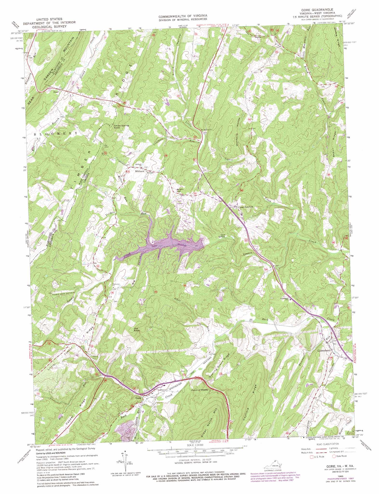
Gore Topo Map Virginia
To zoom in, hover over the map of Gore
USGS Topo Quad 39078c3 - 1:24,000 scale
| Topo Map Name: | Gore |
| USGS Topo Quad ID: | 39078c3 |
| Print Size: | ca. 21 1/4" wide x 27" high |
| Southeast Coordinates: | 39.25° N latitude / 78.25° W longitude |
| Map Center Coordinates: | 39.3125° N latitude / 78.3125° W longitude |
| U.S. States: | VA, WV |
| Filename: | o39078c3.jpg |
| Download Map JPG Image: | Gore topo map 1:24,000 scale |
| Map Type: | Topographic |
| Topo Series: | 7.5´ |
| Map Scale: | 1:24,000 |
| Source of Map Images: | United States Geological Survey (USGS) |
| Alternate Map Versions: |
Gore VA 1965, updated 1967 Download PDF Buy paper map Gore VA 1965, updated 1973 Download PDF Buy paper map Gore VA 1965, updated 1978 Download PDF Buy paper map Gore VA 1965, updated 1987 Download PDF Buy paper map Gore VA 2011 Download PDF Buy paper map Gore VA 2013 Download PDF Buy paper map Gore VA 2016 Download PDF Buy paper map |
1:24,000 Topo Quads surrounding Gore
Oldtown |
Paw Paw |
Great Cacapon |
Stotlers Crossroads |
Big Pool |
Levels |
Largent |
Ridge |
Glengary |
Tablers Station |
Hanging Rock |
Capon Bridge |
Gore |
White Hall |
Inwood |
Yellow Spring |
Capon Springs |
Hayfield |
Winchester |
Stephenson |
Wardensville |
Mountain Falls |
Middletown |
Stephens City |
Boyce |
> Back to 39078a1 at 1:100,000 scale
> Back to 39078a1 at 1:250,000 scale
> Back to U.S. Topo Maps home
Gore topo map: Gazetteer
Gore: Airports
Als Field elevation 335m 1099′Timber Ridge Airpark elevation 303m 994′
Gore: Dams
Indian Run Dam elevation 243m 797′The Summit Dam elevation 257m 843′
Gore: Parks
Gainesboro Neighborhood Park elevation 208m 682′Gore: Populated Places
Collinsville elevation 303m 994′Country Club Heights elevation 280m 918′
Cross Junction elevation 297m 974′
Fairway Heights elevation 290m 951′
Fairway Meadows elevation 301m 987′
Gainesboro elevation 199m 652′
Good elevation 351m 1151′
Gore elevation 219m 718′
Lakewood Acres elevation 277m 908′
Mosswood Hills elevation 287m 941′
Mountain View Acres elevation 313m 1026′
Nordic Village elevation 272m 892′
Northwood Hills elevation 270m 885′
Rolling Hills elevation 293m 961′
Southwood Hills elevation 291m 954′
The Knolls elevation 352m 1154′
Timber Ridge elevation 330m 1082′
Whitacre elevation 306m 1003′
Wildwood Hills elevation 298m 977′
Gore: Post Offices
Cross Junction Post Office elevation 295m 967′Gore Post Office elevation 217m 711′
Whitacre Post Office elevation 315m 1033′
Gore: Ranges
Great North Mountain elevation 421m 1381′Gore: Reservoirs
Cacapon State Park Lake elevation 243m 797′Lake Holiday elevation 257m 843′
Gore: Ridges
Besor Ridge elevation 288m 944′Bowling Green Ridge elevation 254m 833′
Capper Ridge elevation 326m 1069′
Hayfield Ridge elevation 358m 1174′
Little Timber Ridge elevation 386m 1266′
Timber Ridge elevation 410m 1345′
Timber Ridge elevation 397m 1302′
Gore: Springs
Cold Spring elevation 221m 725′Gore: Streams
Albin Run elevation 199m 652′Crockett Run elevation 252m 826′
Dry Run elevation 213m 698′
Little Isaacs Creek elevation 191m 626′
Little Mountain Run elevation 223m 731′
Miller Run elevation 256m 839′
Mine Spring Run elevation 214m 702′
Tavenner Run elevation 185m 606′
Yeiders Run elevation 249m 816′
Gore: Summits
Acorn Hill elevation 323m 1059′Bear Garden Mountain elevation 402m 1318′
Chine Spring Knob elevation 395m 1295′
Chine Spring Knob elevation 397m 1302′
Old Knob elevation 401m 1315′
Point of Rocks elevation 268m 879′
Gore: Valleys
Big Hollow elevation 249m 816′Grove Hollow elevation 267m 875′
Woodpile Hollow elevation 229m 751′
Gore digital topo map on disk
Buy this Gore topo map showing relief, roads, GPS coordinates and other geographical features, as a high-resolution digital map file on DVD:
 map DVD")