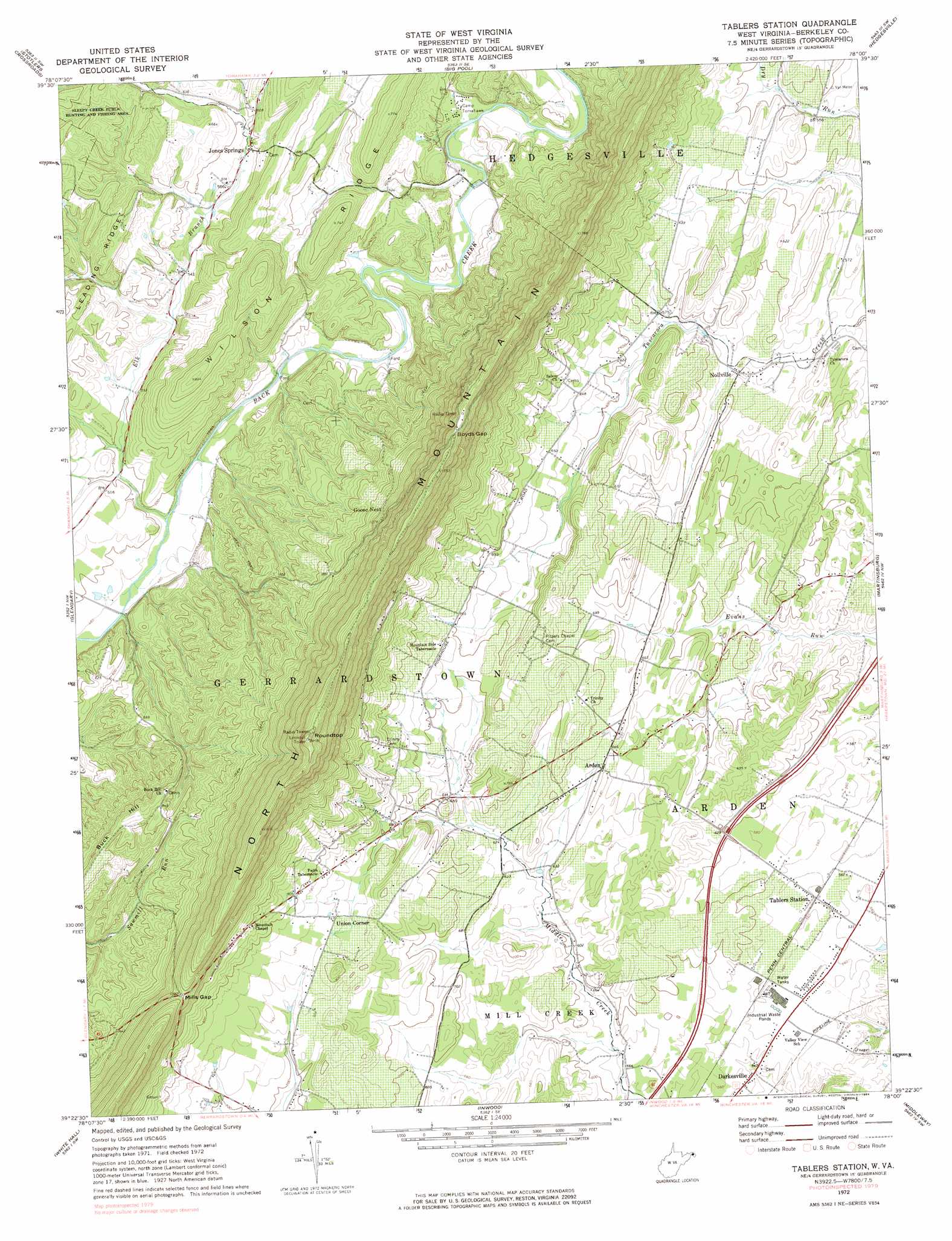
Tablers Station Topo Map West Virginia
To zoom in, hover over the map of Tablers Station
USGS Topo Quad 39078d1 - 1:24,000 scale
| Topo Map Name: | Tablers Station |
| USGS Topo Quad ID: | 39078d1 |
| Print Size: | ca. 21 1/4" wide x 27" high |
| Southeast Coordinates: | 39.375° N latitude / 78° W longitude |
| Map Center Coordinates: | 39.4375° N latitude / 78.0625° W longitude |
| U.S. State: | WV |
| Filename: | o39078d1.jpg |
| Download Map JPG Image: | Tablers Station topo map 1:24,000 scale |
| Map Type: | Topographic |
| Topo Series: | 7.5´ |
| Map Scale: | 1:24,000 |
| Source of Map Images: | United States Geological Survey (USGS) |
| Alternate Map Versions: |
Tablers Station WV 1972, updated 1974 Download PDF Buy paper map Tablers Station WV 1972, updated 1984 Download PDF Buy paper map Tablers Station WV 2011 Download PDF Buy paper map Tablers Station WV 2014 Download PDF Buy paper map Tablers Station WV 2016 Download PDF Buy paper map |
1:24,000 Topo Quads surrounding Tablers Station
Bellegrove |
Hancock |
Cherry Run |
Clear Spring |
Mason-Dixon |
Great Cacapon |
Stotlers Crossroads |
Big Pool |
Hedgesville |
Williamsport |
Ridge |
Glengary |
Tablers Station |
Martinsburg |
Shepherdstown |
Gore |
White Hall |
Inwood |
Middleway |
Charles Town |
Hayfield |
Winchester |
Stephenson |
Berryville |
Round Hill |
> Back to 39078a1 at 1:100,000 scale
> Back to 39078a1 at 1:250,000 scale
> Back to U.S. Topo Maps home
Tablers Station topo map: Gazetteer
Tablers Station: Gaps
Boyds Gap elevation 452m 1482′Mills Gap elevation 329m 1079′
Tablers Station: Parks
Ridge Road Historic District elevation 171m 561′Tablers Station: Populated Places
Arden elevation 202m 662′Goose Nest elevation 334m 1095′
Jones Springs elevation 175m 574′
Nollville elevation 171m 561′
Penry (historical) elevation 139m 456′
Tablers Station elevation 171m 561′
Union Corner elevation 227m 744′
Tablers Station: Post Offices
Jones Springs Post Office elevation 175m 574′Tablers Station: Ridges
Buck Hill elevation 264m 866′North Mountain elevation 502m 1646′
Wilson Ridge elevation 218m 715′
Tablers Station: Springs
Buck Hill Spring elevation 241m 790′Burkhart Spring elevation 230m 754′
Griffith Spring elevation 194m 636′
Jones Spring elevation 178m 583′
Kees Spring elevation 175m 574′
Kitchen Spring elevation 172m 564′
McDonald Spring elevation 168m 551′
Tablers Station: Streams
Elk Branch elevation 143m 469′Tablers Station: Summits
Roundtop elevation 512m 1679′Tablers Station digital topo map on disk
Buy this Tablers Station topo map showing relief, roads, GPS coordinates and other geographical features, as a high-resolution digital map file on DVD:
 map DVD")