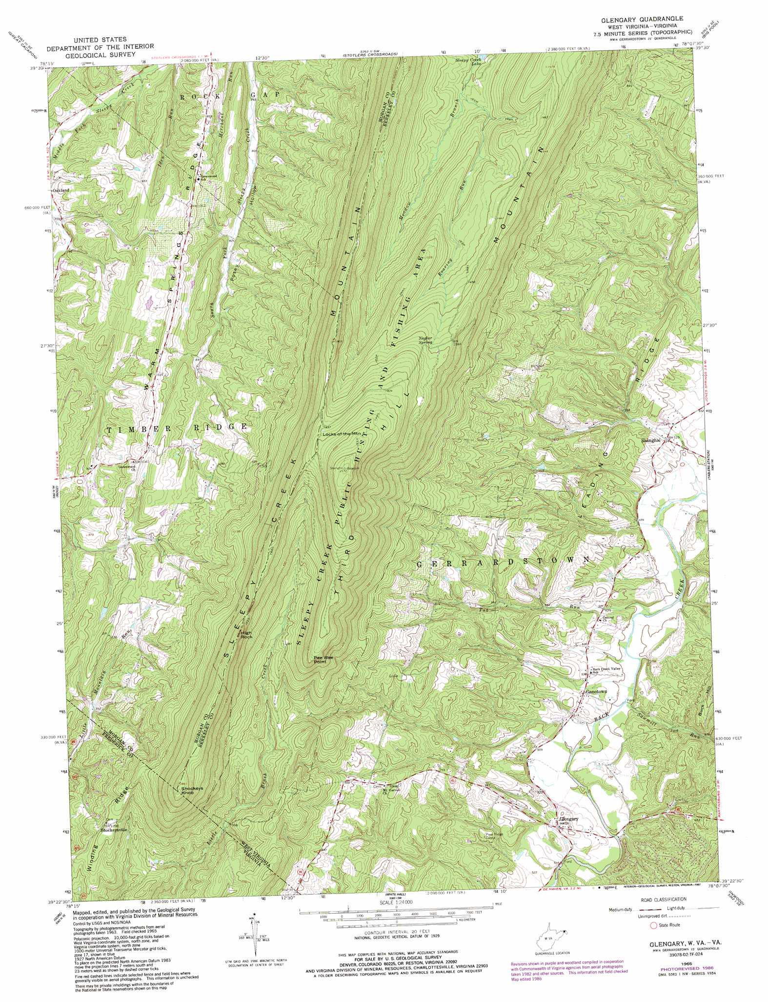
Glengary Topo Map West Virginia
To zoom in, hover over the map of Glengary
USGS Topo Quad 39078d2 - 1:24,000 scale
| Topo Map Name: | Glengary |
| USGS Topo Quad ID: | 39078d2 |
| Print Size: | ca. 21 1/4" wide x 27" high |
| Southeast Coordinates: | 39.375° N latitude / 78.125° W longitude |
| Map Center Coordinates: | 39.4375° N latitude / 78.1875° W longitude |
| U.S. States: | WV, VA |
| Filename: | o39078d2.jpg |
| Download Map JPG Image: | Glengary topo map 1:24,000 scale |
| Map Type: | Topographic |
| Topo Series: | 7.5´ |
| Map Scale: | 1:24,000 |
| Source of Map Images: | United States Geological Survey (USGS) |
| Alternate Map Versions: |
Glengary WV 1965, updated 1967 Download PDF Buy paper map Glengary WV 1965, updated 1987 Download PDF Buy paper map Glengary WV 1996, updated 2001 Download PDF Buy paper map Glengary WV 2011 Download PDF Buy paper map Glengary WV 2014 Download PDF Buy paper map Glengary WV 2016 Download PDF Buy paper map |
1:24,000 Topo Quads surrounding Glengary
Artemas |
Bellegrove |
Hancock |
Cherry Run |
Clear Spring |
Paw Paw |
Great Cacapon |
Stotlers Crossroads |
Big Pool |
Hedgesville |
Largent |
Ridge |
Glengary |
Tablers Station |
Martinsburg |
Capon Bridge |
Gore |
White Hall |
Inwood |
Middleway |
Capon Springs |
Hayfield |
Winchester |
Stephenson |
Berryville |
> Back to 39078a1 at 1:100,000 scale
> Back to 39078a1 at 1:250,000 scale
> Back to U.S. Topo Maps home
Glengary topo map: Gazetteer
Glengary: Airports
Michaels Farm Airport elevation 154m 505′Glengary: Capes
Pee Wee Point elevation 488m 1601′Glengary: Populated Places
Ganotown elevation 166m 544′Glengary elevation 179m 587′
Greenwood elevation 321m 1053′
Shanghai elevation 161m 528′
Shockeysville elevation 365m 1197′
Glengary: Post Offices
Glengary Post Office elevation 154m 505′Glengary: Reservoirs
Sleepy Creek Lake elevation 335m 1099′Glengary: Ridges
Leading Ridge elevation 220m 721′Middle Ridge elevation 458m 1502′
Third Hill Mountain elevation 660m 2165′
Winding Ridge elevation 339m 1112′
Glengary: Springs
Neglar Spring elevation 484m 1587′Shanghai Sulphur Well Spring elevation 158m 518′
Glengary: Streams
Big Run elevation 151m 495′Roaring Run elevation 340m 1115′
Sawmill Run elevation 150m 492′
Tub Run elevation 147m 482′
Glengary: Summits
High Rock elevation 529m 1735′Shockeys Knob elevation 567m 1860′
Shockeys Knob elevation 567m 1860′
Sleepy Creek Mountain elevation 580m 1902′
Glengary digital topo map on disk
Buy this Glengary topo map showing relief, roads, GPS coordinates and other geographical features, as a high-resolution digital map file on DVD:
 map DVD")