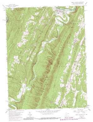
Great Cacapon Topo Map West Virginia
To zoom in, hover over the map of Great Cacapon
USGS Topo Quad 39078e3 - 1:24,000 scale
| Topo Map Name: | Great Cacapon |
| USGS Topo Quad ID: | 39078e3 |
| Print Size: | ca. 21 1/4" wide x 27" high |
| Southeast Coordinates: | 39.5° N latitude / 78.25° W longitude |
| Map Center Coordinates: | 39.5625° N latitude / 78.3125° W longitude |
| U.S. States: | WV, MD |
| Filename: | o39078e3.jpg |
| Download Map JPG Image: | Great Cacapon topo map 1:24,000 scale |
| Map Type: | Topographic |
| Topo Series: | 7.5´ |
| Map Scale: | 1:24,000 |
| Source of Map Images: | United States Geological Survey (USGS) |
| Alternate Map Versions: |
Great Cacapon WV 1958, updated 1959 Download PDF Buy paper map Great Cacapon WV 1958, updated 1967 Download PDF Buy paper map Great Cacapon WV 1958, updated 1976 Download PDF Buy paper map Great Cacapon WV 1958, updated 1987 Download PDF Buy paper map Great Cacapon WV 1996, updated 2001 Download PDF Buy paper map Great Cacapon WV 2011 Download PDF Buy paper map Great Cacapon WV 2014 Download PDF Buy paper map Great Cacapon WV 2016 Download PDF Buy paper map |
1:24,000 Topo Quads surrounding Great Cacapon
> Back to 39078e1 at 1:100,000 scale
> Back to 39078a1 at 1:250,000 scale
> Back to U.S. Topo Maps home
Great Cacapon topo map: Gazetteer
Great Cacapon: Bridges
Fishers Bridge elevation 154m 505′Great Cacapon: Capes
Prospect Rock elevation 471m 1545′Great Cacapon: Crossings
Fisher Ford elevation 156m 511′Harland Ford elevation 150m 492′
Spring Ford elevation 156m 511′
Ziver Ford elevation 153m 501′
Great Cacapon: Dams
Cacapon New Water Supply Dam elevation 307m 1007′Coolfont Dam elevation 240m 787′
Lock 54 elevation 131m 429′
Old Cacapon Power Dam elevation 135m 442′
Unnamed Lake on Tr-Sleepy Creek Dam elevation 280m 918′
Great Cacapon: Parks
Cacapon Resort State Park elevation 387m 1269′Great Cacapon: Populated Places
Great Cacapon elevation 145m 475′Great Cacapon: Post Offices
Great Cacapon Post Office elevation 146m 479′Great Cacapon: Reservoirs
Cacapon Lake elevation 307m 1007′Great Cacapon: Ridges
Bare Ridge elevation 292m 958′Piney Ridge elevation 402m 1318′
Road Ridge elevation 246m 807′
Tonoloway Ridge elevation 300m 984′
Tonoloway Ridge elevation 300m 984′
Warm Springs Ridge elevation 332m 1089′
Great Cacapon: Springs
Cacapon State Park Spring elevation 274m 898′Coolfont Spring elevation 248m 813′
Fahren Spring elevation 279m 915′
Mitchum Farm Spring elevation 210m 688′
Neely Farm Spring elevation 251m 823′
Whisner Farm Spring elevation 237m 777′
Ziler Spring elevation 166m 544′
Great Cacapon: Streams
Cacapon River elevation 127m 416′Constant Run elevation 156m 511′
Long Hollow Run elevation 131m 429′
Middle Fork Indian Run elevation 287m 941′
North Indian Run elevation 263m 862′
Rock Gap Run elevation 212m 695′
Rockwell Run elevation 135m 442′
South Fork Indian Run elevation 266m 872′
South Fork Indian Run elevation 264m 866′
Whisners Run elevation 198m 649′
Wiggins Run elevation 192m 629′
Great Cacapon: Summits
Cedar Hill elevation 244m 800′Edes Fort elevation 214m 702′
Fluted Rocks elevation 250m 820′
Purslane Mountain elevation 568m 1863′
Great Cacapon: Valleys
Connor Hollow elevation 163m 534′Long Hollow elevation 131m 429′
Rocky Hollow elevation 181m 593′
Stinebaugh Hollow elevation 204m 669′
Great Cacapon digital topo map on disk
Buy this Great Cacapon topo map showing relief, roads, GPS coordinates and other geographical features, as a high-resolution digital map file on DVD:


