Oldtown Topo Map Maryland
To zoom in, hover over the map of Oldtown
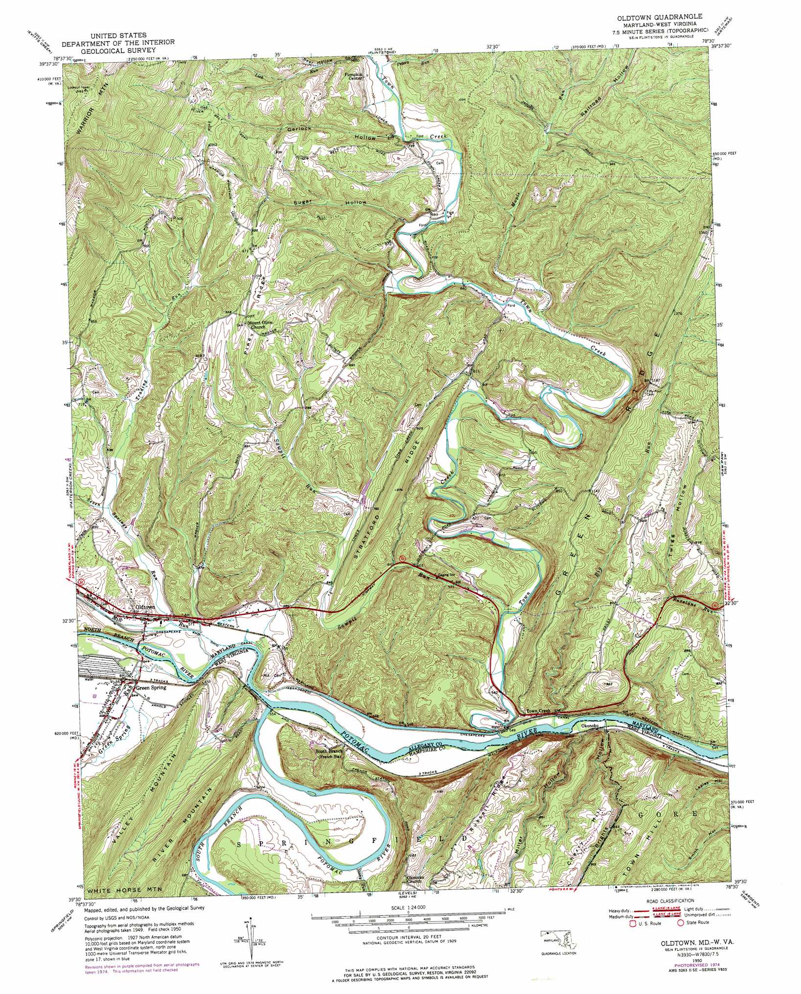
USGS Topo Quad 39078e5 - 1:24,000 scale
| Topo Map Name: | Oldtown |
| USGS Topo Quad ID: | 39078e5 |
| Print Size: | ca. 21 1/4" wide x 27" high |
| Southeast Coordinates: | 39.5° N latitude / 78.5° W longitude |
| Map Center Coordinates: | 39.5625° N latitude / 78.5625° W longitude |
| U.S. States: | MD, WV |
| Filename: | o39078e5.jpg |
| Download Map JPG Image: | Oldtown topo map 1:24,000 scale |
| Map Type: | Topographic |
| Topo Series: | 7.5´ |
| Map Scale: | 1:24,000 |
| Source of Map Images: | United States Geological Survey (USGS) |
| Alternate Map Versions: |
Oldtown MD 1950, updated 1965 Download PDF Buy paper map Oldtown MD 1950, updated 1976 Download PDF Buy paper map Oldtown MD 1951 Download PDF Buy paper map Oldtown MD 1951, updated 1951 Download PDF Buy paper map Oldtown MD 1998, updated 1999 Download PDF Buy paper map Oldtown MD 2011 Download PDF Buy paper map Oldtown MD 2014 Download PDF Buy paper map Oldtown MD 2016 Download PDF Buy paper map |
1:24,000 Topo Quads surrounding Oldtown
Fairhope |
Hyndman |
Beans Cove |
Chaneysville |
Amaranth |
Cumberland |
Evitts Creek |
Flintstone |
Artemas |
Bellegrove |
Cresaptown |
Patterson Creek |
Oldtown |
Paw Paw |
Great Cacapon |
Headsville |
Springfield |
Levels |
Largent |
Ridge |
Romney |
Augusta |
Hanging Rock |
Capon Bridge |
Gore |
> Back to 39078e1 at 1:100,000 scale
> Back to 39078a1 at 1:250,000 scale
> Back to U.S. Topo Maps home
Oldtown topo map: Gazetteer
Oldtown: Bridges
Town Creek Aqueduct elevation 160m 524′Oldtown: Dams
Lock 67 elevation 164m 538′Lock 68 elevation 165m 541′
Lock 69 elevation 163m 534′
Lock 70 elevation 171m 561′
Lock 71 elevation 177m 580′
Paul Roeder Farm Pond Dam elevation 169m 554′
Oldtown: Populated Places
Green Spring elevation 169m 554′Okonoko elevation 173m 567′
Oldtown elevation 173m 567′
Picardy elevation 280m 918′
Pumpkin Center elevation 213m 698′
Town Creek elevation 181m 593′
Oldtown: Post Offices
Oldtown Post Office elevation 171m 561′Oldtown: Reservoirs
Paul Roeder Farm Pond elevation 169m 554′Oldtown: Ridges
Pine Ridge elevation 305m 1000′Russell Ridge elevation 321m 1053′
Stratford Ridge elevation 292m 958′
Oldtown: Springs
Green Spring elevation 195m 639′Oldtown: Streams
Big Run elevation 158m 518′Green Spring Run elevation 161m 528′
Maple Run elevation 192m 629′
Mill Run elevation 161m 528′
North Branch Potomac River elevation 160m 524′
Peters Run elevation 206m 675′
Sawpit Run elevation 165m 541′
Seven Springs Run elevation 166m 544′
South Branch Potomac River elevation 160m 524′
Stony Run elevation 164m 538′
Town Creek elevation 173m 567′
Trading Run elevation 180m 590′
Oldtown: Summits
Warrior Mountain elevation 650m 2132′Oldtown: Valleys
Brights Hollow elevation 164m 538′Gerlock Hollow elevation 201m 659′
Miller Hollow elevation 163m 534′
Railroad Hollow elevation 216m 708′
Sugar Hollow elevation 200m 656′
Twigs Hollow elevation 206m 675′
Oldtown digital topo map on disk
Buy this Oldtown topo map showing relief, roads, GPS coordinates and other geographical features, as a high-resolution digital map file on DVD:
 map DVD")