Patterson Creek Topo Map Maryland
To zoom in, hover over the map of Patterson Creek
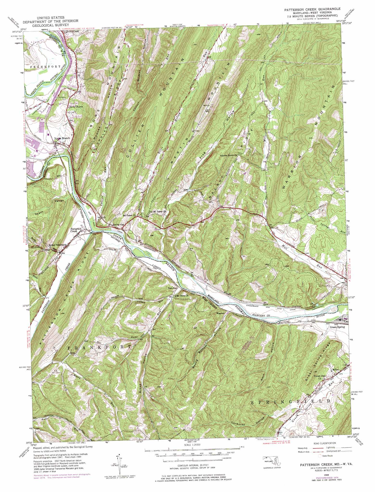
USGS Topo Quad 39078e6 - 1:24,000 scale
| Topo Map Name: | Patterson Creek |
| USGS Topo Quad ID: | 39078e6 |
| Print Size: | ca. 21 1/4" wide x 27" high |
| Southeast Coordinates: | 39.5° N latitude / 78.625° W longitude |
| Map Center Coordinates: | 39.5625° N latitude / 78.6875° W longitude |
| U.S. States: | MD, WV |
| Filename: | o39078e6.jpg |
| Download Map JPG Image: | Patterson Creek topo map 1:24,000 scale |
| Map Type: | Topographic |
| Topo Series: | 7.5´ |
| Map Scale: | 1:24,000 |
| Source of Map Images: | United States Geological Survey (USGS) |
| Alternate Map Versions: |
Patterson Creek WV 1949, updated 1963 Download PDF Buy paper map Patterson Creek WV 1949, updated 1968 Download PDF Buy paper map Patterson Creek WV 1949, updated 1975 Download PDF Buy paper map Patterson Creek WV 1951 Download PDF Buy paper map Pattersons Creek WV 1951 Download PDF Buy paper map Patterson Creek WV 1996, updated 2001 Download PDF Buy paper map Patterson Creek WV 2011 Download PDF Buy paper map Patterson Creek WV 2014 Download PDF Buy paper map Patterson Creek WV 2016 Download PDF Buy paper map |
1:24,000 Topo Quads surrounding Patterson Creek
Wittenberg |
Fairhope |
Hyndman |
Beans Cove |
Chaneysville |
Frostburg |
Cumberland |
Evitts Creek |
Flintstone |
Artemas |
Lonaconing |
Cresaptown |
Patterson Creek |
Oldtown |
Paw Paw |
Keyser |
Headsville |
Springfield |
Levels |
Largent |
Burlington |
Romney |
Augusta |
Hanging Rock |
Capon Bridge |
> Back to 39078e1 at 1:100,000 scale
> Back to 39078a1 at 1:250,000 scale
> Back to U.S. Topo Maps home
Patterson Creek topo map: Gazetteer
Patterson Creek: Dams
Lock 72 elevation 171m 561′Lock 73 elevation 177m 580′
Lock 74 elevation 173m 567′
Patterson Creek: Parks
Warrior Mountain State Wildlife Management Area elevation 478m 1568′Patterson Creek: Populated Places
Dans Run elevation 173m 567′Evitts Creek elevation 201m 659′
Mexico elevation 184m 603′
Millen elevation 176m 577′
North Branch elevation 198m 649′
Patterson Creek elevation 208m 682′
Spring Gap elevation 183m 600′
Wagoner elevation 170m 557′
Patterson Creek: Post Offices
Spring Gap Post Office elevation 182m 597′Patterson Creek: Ridges
Green Spring Ridge elevation 260m 853′Nicholas Ridge elevation 418m 1371′
Patterson Creek Ridge elevation 397m 1302′
Walnut Ridge elevation 290m 951′
Patterson Creek: Springs
Blue Spring elevation 169m 554′Patterson Creek: Streams
Brice Hollow Run elevation 167m 547′Cattail Run elevation 170m 557′
Collier Run elevation 169m 554′
Dans Run elevation 172m 564′
Evitts Creek elevation 179m 587′
Patterson Creek elevation 169m 554′
Plum Run elevation 173m 567′
Rocky Run elevation 170m 557′
Patterson Creek: Summits
Collier Mountain elevation 444m 1456′Patterson Creek: Valleys
Broad Hollow elevation 185m 606′Corduroy Hollow elevation 186m 610′
Death Valley elevation 171m 561′
Frog Hollow elevation 199m 652′
Kern Hollow elevation 168m 551′
Moores Hollow elevation 188m 616′
Round Bottom Hollow elevation 166m 544′
Wildcat Hollow elevation 252m 826′
Patterson Creek digital topo map on disk
Buy this Patterson Creek topo map showing relief, roads, GPS coordinates and other geographical features, as a high-resolution digital map file on DVD:
 map DVD")