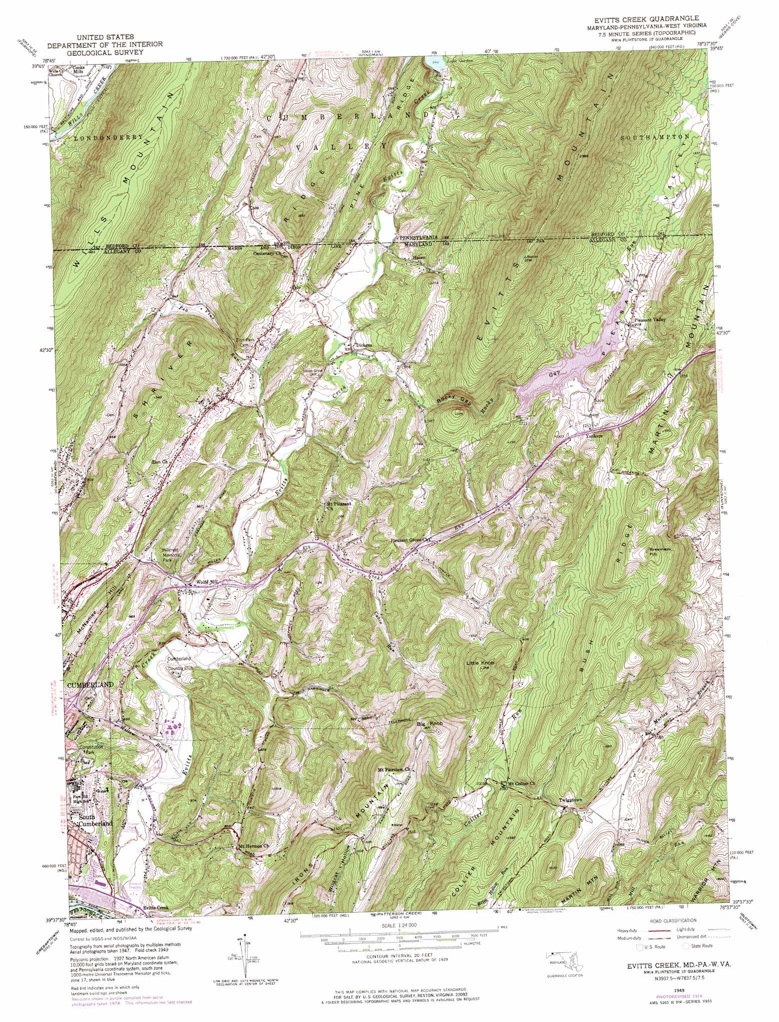
Evitts Creek Topo Map Maryland
To zoom in, hover over the map of Evitts Creek
USGS Topo Quad 39078f6 - 1:24,000 scale
| Topo Map Name: | Evitts Creek |
| USGS Topo Quad ID: | 39078f6 |
| Print Size: | ca. 21 1/4" wide x 27" high |
| Southeast Coordinates: | 39.625° N latitude / 78.625° W longitude |
| Map Center Coordinates: | 39.6875° N latitude / 78.6875° W longitude |
| U.S. States: | MD, WV, PA |
| Filename: | o39078f6.jpg |
| Download Map JPG Image: | Evitts Creek topo map 1:24,000 scale |
| Map Type: | Topographic |
| Topo Series: | 7.5´ |
| Map Scale: | 1:24,000 |
| Source of Map Images: | United States Geological Survey (USGS) |
| Alternate Map Versions: |
Evitts Creek MD 1949, updated 1961 Download PDF Buy paper map Evitts Creek MD 1949, updated 1972 Download PDF Buy paper map Evitts Creek MD 1949, updated 1975 Download PDF Buy paper map Evitts Creek MD 1951 Download PDF Buy paper map Evitts Creek MD 1951 Download PDF Buy paper map Evitts Creek MD 2011 Download PDF Buy paper map Evitts Creek MD 2014 Download PDF Buy paper map Evitts Creek MD 2016 Download PDF Buy paper map |
1:24,000 Topo Quads surrounding Evitts Creek
Berlin |
New Baltimore |
Buffalo Mills |
Rainsburg |
Clearville |
Wittenberg |
Fairhope |
Hyndman |
Beans Cove |
Chaneysville |
Frostburg |
Cumberland |
Evitts Creek |
Flintstone |
Artemas |
Lonaconing |
Cresaptown |
Patterson Creek |
Oldtown |
Paw Paw |
Keyser |
Headsville |
Springfield |
Levels |
Largent |
> Back to 39078e1 at 1:100,000 scale
> Back to 39078a1 at 1:250,000 scale
> Back to U.S. Topo Maps home
Evitts Creek topo map: Gazetteer
Evitts Creek: Bridges
Evitts Creek Aqueduct elevation 181m 593′Evitts Creek: Crossings
Interchange 44 elevation 232m 761′Interchange 45 elevation 274m 898′
Interchange 46 elevation 202m 662′
Interchange 47 elevation 213m 698′
Evitts Creek: Dams
Lake Gordon Dam elevation 283m 928′Rocky Gap Dam elevation 366m 1200′
Evitts Creek: Gaps
Rocky Gap elevation 302m 990′Evitts Creek: Parks
Constitution Park elevation 291m 954′Rock Gap State Park elevation 399m 1309′
Evitts Creek: Populated Places
Bowmans Addition elevation 262m 859′Cooks Mills elevation 239m 784′
Dickens elevation 238m 780′
Hazen elevation 273m 895′
Pleasant Grove elevation 249m 816′
Pleasant Valley elevation 369m 1210′
Twiggtown elevation 363m 1190′
Wolfe Mill elevation 205m 672′
Yonkers elevation 381m 1250′
Evitts Creek: Reservoirs
Lake Gordon elevation 290m 951′Lake Habeeb elevation 366m 1200′
Evitts Creek: Ridges
Bush Ridge elevation 471m 1545′Pine Ridge elevation 297m 974′
Shriver Ridge elevation 461m 1512′
Shriver Ridge elevation 445m 1459′
Evitts Creek: Streams
Cabin Run elevation 238m 780′Pea Vine Run elevation 209m 685′
Pea Vine Run elevation 225m 738′
Rocky Gap Run elevation 226m 741′
Evitts Creek: Summits
Big Knob elevation 552m 1811′Breakneck Hill elevation 579m 1899′
Evitts Mountain elevation 691m 2267′
Irons Mountain elevation 550m 1804′
Little Knob elevation 518m 1699′
Martin Mountain elevation 515m 1689′
McNamee Hill elevation 276m 905′
Evitts Creek digital topo map on disk
Buy this Evitts Creek topo map showing relief, roads, GPS coordinates and other geographical features, as a high-resolution digital map file on DVD:
 map DVD")