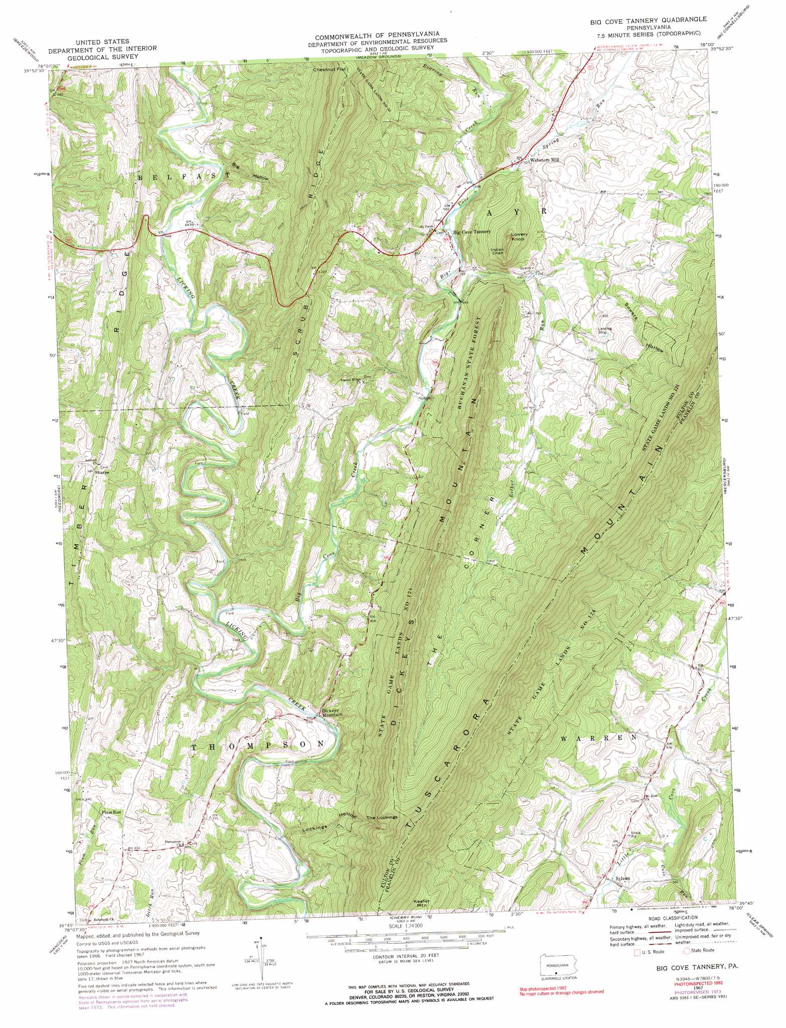
Big Cove Tannery Topo Map Pennsylvania
To zoom in, hover over the map of Big Cove Tannery
USGS Topo Quad 39078g1 - 1:24,000 scale
| Topo Map Name: | Big Cove Tannery |
| USGS Topo Quad ID: | 39078g1 |
| Print Size: | ca. 21 1/4" wide x 27" high |
| Southeast Coordinates: | 39.75° N latitude / 78° W longitude |
| Map Center Coordinates: | 39.8125° N latitude / 78.0625° W longitude |
| U.S. State: | PA |
| Filename: | o39078g1.jpg |
| Download Map JPG Image: | Big Cove Tannery topo map 1:24,000 scale |
| Map Type: | Topographic |
| Topo Series: | 7.5´ |
| Map Scale: | 1:24,000 |
| Source of Map Images: | United States Geological Survey (USGS) |
| Alternate Map Versions: |
Big Cove Tannery PA 1967, updated 1970 Download PDF Buy paper map Big Cove Tannery PA 1967, updated 1973 Download PDF Buy paper map Big Cove Tannery PA 1967, updated 1991 Download PDF Buy paper map Big Cove Tannery PA 1994, updated 1997 Download PDF Buy paper map Big Cove Tannery PA 2010 Download PDF Buy paper map Big Cove Tannery PA 2013 Download PDF Buy paper map Big Cove Tannery PA 2016 Download PDF Buy paper map |
1:24,000 Topo Quads surrounding Big Cove Tannery
Everett East |
Wells Tannery |
Hustontown |
Burnt Cabins |
Fannettsburg |
Mench |
Breezewood |
Meadow Grounds |
Mcconnellsburg |
Saint Thomas |
Amaranth |
Needmore |
Big Cove Tannery |
Mercersburg |
Williamson |
Bellegrove |
Hancock |
Cherry Run |
Clear Spring |
Mason-Dixon |
Great Cacapon |
Stotlers Crossroads |
Big Pool |
Hedgesville |
Williamsport |
> Back to 39078e1 at 1:100,000 scale
> Back to 39078a1 at 1:250,000 scale
> Back to U.S. Topo Maps home
Big Cove Tannery topo map: Gazetteer
Big Cove Tannery: Cliffs
The Lockings elevation 516m 1692′Big Cove Tannery: Parks
Redbud Valley Nature Center elevation 199m 652′State Game Lands Number 124 elevation 359m 1177′
Big Cove Tannery: Populated Places
Big Cove Tannery elevation 201m 659′Dickeys Mountain elevation 163m 534′
Plum Run elevation 253m 830′
Sharpe elevation 270m 885′
Sylvan elevation 152m 498′
Websters Mill elevation 215m 705′
Big Cove Tannery: Ridges
Chestnut Flat elevation 536m 1758′Dickeys Mountain elevation 483m 1584′
Timber Ridge elevation 276m 905′
Big Cove Tannery: Springs
Big Spring elevation 213m 698′Big Cove Tannery: Streams
Big Cove Creek elevation 164m 538′Cave Run elevation 152m 498′
Esther Run elevation 196m 643′
Roaring Run elevation 223m 731′
Spring Run elevation 213m 698′
Big Cove Tannery: Summits
Indian Chair elevation 346m 1135′Lowery Knob elevation 377m 1236′
Big Cove Tannery: Valleys
Big Hollow elevation 209m 685′Lockings Hollow elevation 157m 515′
Sowers Hollow elevation 245m 803′
The Corner elevation 246m 807′
Big Cove Tannery digital topo map on disk
Buy this Big Cove Tannery topo map showing relief, roads, GPS coordinates and other geographical features, as a high-resolution digital map file on DVD:
 map DVD")