Beans Cove Topo Map Pennsylvania
To zoom in, hover over the map of Beans Cove
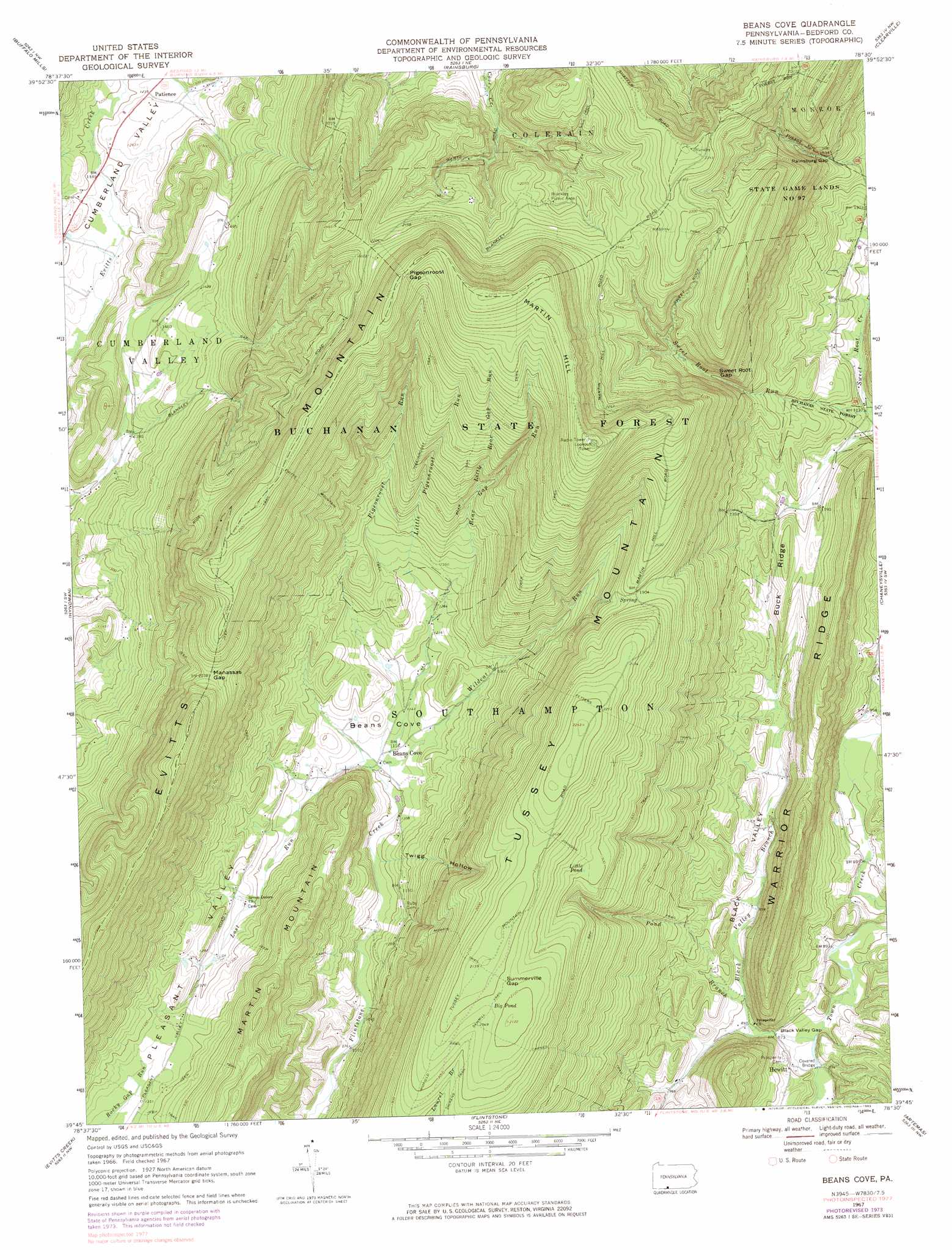
USGS Topo Quad 39078g5 - 1:24,000 scale
| Topo Map Name: | Beans Cove |
| USGS Topo Quad ID: | 39078g5 |
| Print Size: | ca. 21 1/4" wide x 27" high |
| Southeast Coordinates: | 39.75° N latitude / 78.5° W longitude |
| Map Center Coordinates: | 39.8125° N latitude / 78.5625° W longitude |
| U.S. State: | PA |
| Filename: | o39078g5.jpg |
| Download Map JPG Image: | Beans Cove topo map 1:24,000 scale |
| Map Type: | Topographic |
| Topo Series: | 7.5´ |
| Map Scale: | 1:24,000 |
| Source of Map Images: | United States Geological Survey (USGS) |
| Alternate Map Versions: |
Beans Cove PA 1967, updated 1970 Download PDF Buy paper map Beans Cove PA 1967, updated 1973 Download PDF Buy paper map Beans Cove PA 1967, updated 1983 Download PDF Buy paper map Beans Cove PA 1967, updated 1983 Download PDF Buy paper map Beans Cove PA 2010 Download PDF Buy paper map Beans Cove PA 2013 Download PDF Buy paper map Beans Cove PA 2016 Download PDF Buy paper map |
1:24,000 Topo Quads surrounding Beans Cove
Central City |
Schellsburg |
Bedford |
Everett West |
Everett East |
New Baltimore |
Buffalo Mills |
Rainsburg |
Clearville |
Mench |
Fairhope |
Hyndman |
Beans Cove |
Chaneysville |
Amaranth |
Cumberland |
Evitts Creek |
Flintstone |
Artemas |
Bellegrove |
Cresaptown |
Patterson Creek |
Oldtown |
Paw Paw |
Great Cacapon |
> Back to 39078e1 at 1:100,000 scale
> Back to 39078a1 at 1:250,000 scale
> Back to U.S. Topo Maps home
Beans Cove topo map: Gazetteer
Beans Cove: Areas
Sweet Root Natural Area elevation 629m 2063′Beans Cove: Bays
Beans Cove elevation 352m 1154′Beans Cove: Bridges
Hewitt Covered Bridge elevation 258m 846′Beans Cove: Forests
Buchanan State Forest elevation 760m 2493′Beans Cove: Gaps
Black Valley Gap elevation 266m 872′Manassas Gap elevation 620m 2034′
Pigeonroost Gap elevation 787m 2582′
Rainsburg Gap elevation 497m 1630′
Summerville Gap elevation 636m 2086′
Sweet Root Gap elevation 487m 1597′
Beans Cove: Lakes
Big Pond elevation 636m 2086′Little Pond elevation 583m 1912′
Beans Cove: Populated Places
Beans Cove elevation 339m 1112′Hewitt elevation 272m 892′
Patience elevation 375m 1230′
Beans Cove: Post Offices
Beans Cove Post Office (historical) elevation 339m 1112′Beans Cove: Ridges
Buck Ridge elevation 406m 1332′Beans Cove: Streams
Bear Gap Run elevation 374m 1227′Black Valley Branch elevation 273m 895′
Blues Gap Run elevation 270m 885′
Little Bear Gap Run elevation 492m 1614′
Little Pigeonroost Run elevation 390m 1279′
Lost Run elevation 335m 1099′
Pigeonroost Run elevation 373m 1223′
Pond Branch elevation 259m 849′
Twigg Hollow Run elevation 325m 1066′
Wildcat Run elevation 337m 1105′
Beans Cove: Summits
Martin Hill elevation 808m 2650′Beans Cove: Trails
Cabin Trail elevation 670m 2198′Carnes Trail elevation 491m 1610′
Evitts Mountain Trail elevation 562m 1843′
Fair View Trail elevation 687m 2253′
Garlick Trail elevation 706m 2316′
May Trail elevation 453m 1486′
Refuge Trail elevation 666m 2185′
Reservoir Trail elevation 632m 2073′
Sawmill Trail elevation 621m 2037′
Tarkiln Trail elevation 607m 1991′
Tower Trail elevation 630m 2066′
Beans Cove: Valleys
Black Valley elevation 268m 879′Twigg Hollow elevation 328m 1076′
Beans Cove digital topo map on disk
Buy this Beans Cove topo map showing relief, roads, GPS coordinates and other geographical features, as a high-resolution digital map file on DVD:
 map DVD")