Buffalo Mills Topo Map Pennsylvania
To zoom in, hover over the map of Buffalo Mills
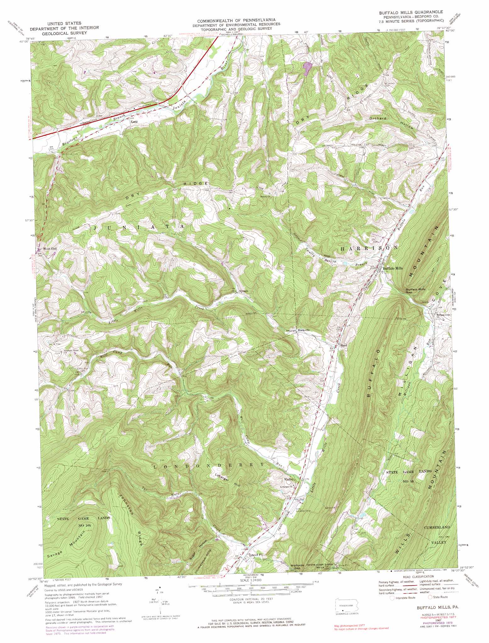
USGS Topo Quad 39078h6 - 1:24,000 scale
| Topo Map Name: | Buffalo Mills |
| USGS Topo Quad ID: | 39078h6 |
| Print Size: | ca. 21 1/4" wide x 27" high |
| Southeast Coordinates: | 39.875° N latitude / 78.625° W longitude |
| Map Center Coordinates: | 39.9375° N latitude / 78.6875° W longitude |
| U.S. State: | PA |
| Filename: | o39078h6.jpg |
| Download Map JPG Image: | Buffalo Mills topo map 1:24,000 scale |
| Map Type: | Topographic |
| Topo Series: | 7.5´ |
| Map Scale: | 1:24,000 |
| Source of Map Images: | United States Geological Survey (USGS) |
| Alternate Map Versions: |
Buffalo Mills PA 1967, updated 1970 Download PDF Buy paper map Buffalo Mills PA 1967, updated 1973 Download PDF Buy paper map Buffalo Mills PA 1967, updated 1984 Download PDF Buy paper map Buffalo Mills PA 2010 Download PDF Buy paper map Buffalo Mills PA 2013 Download PDF Buy paper map Buffalo Mills PA 2016 Download PDF Buy paper map |
1:24,000 Topo Quads surrounding Buffalo Mills
Hooversville |
Windber |
Ogletown |
Alum Bank |
New Enterprise |
Stoystown |
Central City |
Schellsburg |
Bedford |
Everett West |
Berlin |
New Baltimore |
Buffalo Mills |
Rainsburg |
Clearville |
Wittenberg |
Fairhope |
Hyndman |
Beans Cove |
Chaneysville |
Frostburg |
Cumberland |
Evitts Creek |
Flintstone |
Artemas |
> Back to 39078e1 at 1:100,000 scale
> Back to 39078a1 at 1:250,000 scale
> Back to U.S. Topo Maps home
Buffalo Mills topo map: Gazetteer
Buffalo Mills: Airports
Leap Airport elevation 350m 1148′Buffalo Mills: Dams
Joseph Smyth Dam elevation 388m 1272′Buffalo Mills: Gaps
Buffalo Mills Gap elevation 419m 1374′Buffalo Mills: Parks
State Game Lands Number 48 elevation 576m 1889′Buffalo Mills: Populated Places
Bard elevation 389m 1276′Buffalo Mills elevation 503m 1650′
Gravel Pit elevation 341m 1118′
Kegg elevation 384m 1259′
Madley elevation 363m 1190′
Rockville elevation 407m 1335′
West End elevation 554m 1817′
Buffalo Mills: Post Offices
West End Post Office (historical) elevation 554m 1817′Buffalo Mills: Reservoirs
Joseph Smyth Pond elevation 388m 1272′Buffalo Mills: Ridges
Dry Ridge elevation 495m 1624′Evitts Mountain elevation 547m 1794′
Johnston Ridge elevation 740m 2427′
Buffalo Mills: Streams
Milligan Run elevation 421m 1381′Smally Spring Branch elevation 392m 1286′
Tar Water Creek elevation 341m 1118′
Wolf Camp Run elevation 358m 1174′
Buffalo Mills: Summits
Buffalo Mountain elevation 638m 2093′Glade Pike Vista elevation 428m 1404′
Lybarger Hill elevation 541m 1774′
Savage Mountain elevation 813m 2667′
Buffalo Mills: Valleys
Orchard Hollow elevation 370m 1213′Sugar Hollow elevation 364m 1194′
Buffalo Mills digital topo map on disk
Buy this Buffalo Mills topo map showing relief, roads, GPS coordinates and other geographical features, as a high-resolution digital map file on DVD:
 map DVD")