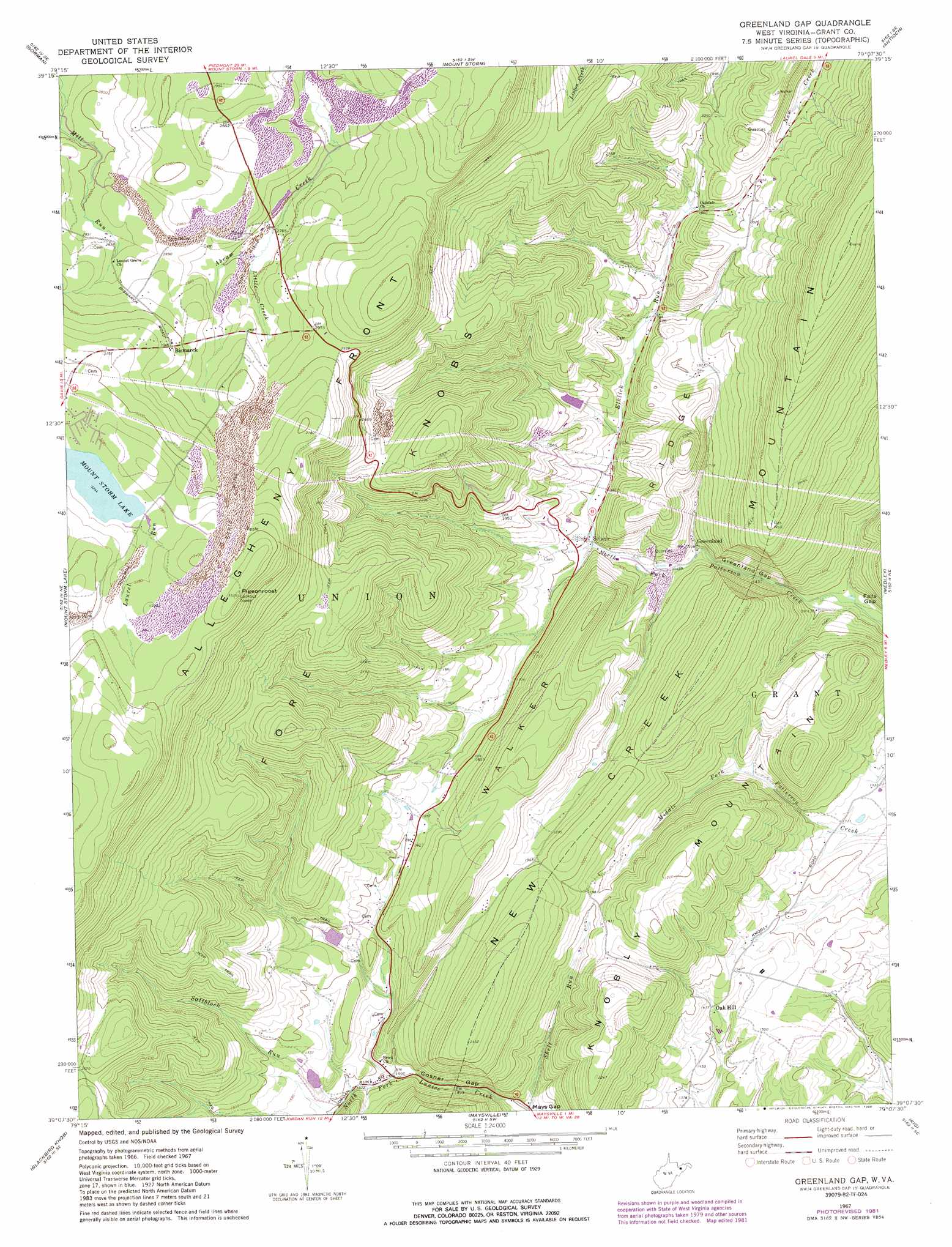
Greenland Gap Topo Map West Virginia
To zoom in, hover over the map of Greenland Gap
USGS Topo Quad 39079b2 - 1:24,000 scale
| Topo Map Name: | Greenland Gap |
| USGS Topo Quad ID: | 39079b2 |
| Print Size: | ca. 21 1/4" wide x 27" high |
| Southeast Coordinates: | 39.125° N latitude / 79.125° W longitude |
| Map Center Coordinates: | 39.1875° N latitude / 79.1875° W longitude |
| U.S. State: | WV |
| Filename: | o39079b2.jpg |
| Download Map JPG Image: | Greenland Gap topo map 1:24,000 scale |
| Map Type: | Topographic |
| Topo Series: | 7.5´ |
| Map Scale: | 1:24,000 |
| Source of Map Images: | United States Geological Survey (USGS) |
| Alternate Map Versions: |
Greenland Gap WV 1967, updated 1972 Download PDF Buy paper map Greenland Gap WV 1967, updated 1977 Download PDF Buy paper map Greenland Gap WV 1967, updated 1982 Download PDF Buy paper map Greenland Gap WV 1967, updated 1988 Download PDF Buy paper map Greenland Gap WV 2011 Download PDF Buy paper map Greenland Gap WV 2014 Download PDF Buy paper map Greenland Gap WV 2016 Download PDF Buy paper map |
1:24,000 Topo Quads surrounding Greenland Gap
Oakland |
Deer Park |
Kitzmiller |
Westernport |
Keyser |
Table Rock |
Gorman |
Mount Storm |
Antioch |
Burlington |
Davis |
Mount Storm Lake |
Greenland Gap |
Medley |
Old Fields |
Blackwater Falls |
Blackbird Knob |
Maysville |
Rig |
Moorefield |
Laneville |
Hopeville |
Petersburg West |
Petersburg East |
Lost River State Park |
> Back to 39079a1 at 1:100,000 scale
> Back to 39078a1 at 1:250,000 scale
> Back to U.S. Topo Maps home
Greenland Gap topo map: Gazetteer
Greenland Gap: Airports
Mount Storm Heliport elevation 851m 2791′Greenland Gap: Dams
Lunice Creek Structure Number 10 Dam elevation 507m 1663′Lunice Creek Structure Number 11 Dam elevation 524m 1719′
Mount Storm Power Station Dam elevation 1004m 3293′
Patterson Creek Structure Number Six Dam elevation 529m 1735′
Greenland Gap: Gaps
Cosner Gap elevation 456m 1496′Greenland Gap elevation 399m 1309′
Greenland Gap: Populated Places
Bismarck elevation 926m 3038′Greenland elevation 460m 1509′
Oak Hill elevation 450m 1476′
Scherr elevation 475m 1558′
Greenland Gap: Post Offices
Scherr Post Office elevation 474m 1555′Greenland Gap: Ridges
Allegheny Front elevation 987m 3238′New Creek Mountain elevation 937m 3074′
Walker Ridge elevation 641m 2103′
Greenland Gap: Springs
Brick Church Spring elevation 481m 1578′Cold Spring elevation 461m 1512′
Greenland Gap: Streams
Elklick Run elevation 471m 1545′Laurel Run elevation 991m 3251′
Little Creek elevation 844m 2769′
Saltblock Run elevation 492m 1614′
Shell Run elevation 428m 1404′
Greenland Gap: Summits
Fore Knobs elevation 834m 2736′Pigeonroost elevation 1074m 3523′
Greenland Gap digital topo map on disk
Buy this Greenland Gap topo map showing relief, roads, GPS coordinates and other geographical features, as a high-resolution digital map file on DVD:
 map DVD")