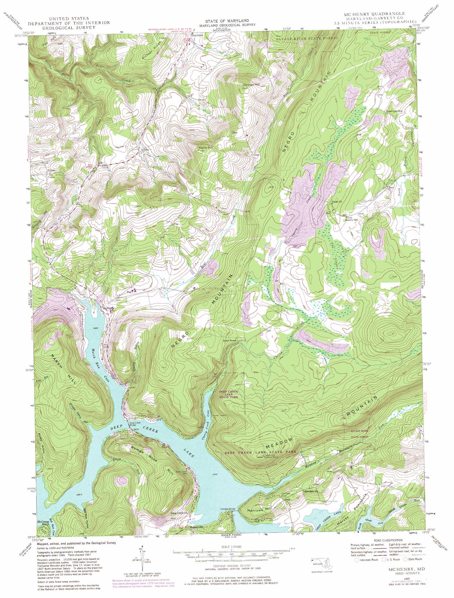
Mchenry Topo Map Maryland
To zoom in, hover over the map of Mchenry
USGS Topo Quad 39079e3 - 1:24,000 scale
| Topo Map Name: | Mchenry |
| USGS Topo Quad ID: | 39079e3 |
| Print Size: | ca. 21 1/4" wide x 27" high |
| Southeast Coordinates: | 39.5° N latitude / 79.25° W longitude |
| Map Center Coordinates: | 39.5625° N latitude / 79.3125° W longitude |
| U.S. State: | MD |
| Filename: | o39079e3.jpg |
| Download Map JPG Image: | Mchenry topo map 1:24,000 scale |
| Map Type: | Topographic |
| Topo Series: | 7.5´ |
| Map Scale: | 1:24,000 |
| Source of Map Images: | United States Geological Survey (USGS) |
| Alternate Map Versions: |
McHenry MD 1947, updated 1965 Download PDF Buy paper map McHenry MD 1947, updated 1971 Download PDF Buy paper map McHenry MD 1947, updated 1975 Download PDF Buy paper map McHenry MD 1947, updated 1982 Download PDF Buy paper map McHenry MD 1949 Download PDF Buy paper map McHenry MD 2011 Download PDF Buy paper map McHenry MD 2014 Download PDF Buy paper map McHenry MD 2016 Download PDF Buy paper map |
1:24,000 Topo Quads surrounding Mchenry
Fort Necessity |
Ohiopyle |
Confluence |
Markleton |
Meyersdale |
Brandonville |
Friendsville |
Accident |
Grantsville |
Avilton |
Cuzzart |
Sang Run |
Mchenry |
Bittinger |
Barton |
Terra Alta |
Oakland |
Deer Park |
Kitzmiller |
Westernport |
Aurora |
Table Rock |
Gorman |
Mount Storm |
Antioch |
> Back to 39079e1 at 1:100,000 scale
> Back to 39078a1 at 1:250,000 scale
> Back to U.S. Topo Maps home
Mchenry topo map: Gazetteer
Mchenry: Airports
Garrett County Airport elevation 896m 2939′Mchenry: Bays
Cherry Creek Cove elevation 750m 2460′Marsh Run Cove elevation 750m 2460′
Red Run Cove elevation 750m 2460′
Mchenry: Bridges
Deep Creek Bridge elevation 750m 2460′Glendale Bridge elevation 750m 2460′
Mchenry: Capes
Harvey Peninsula elevation 762m 2500′Mchenry: Parks
Thayer State Game Refuge elevation 837m 2746′Mchenry: Populated Places
Hoyes elevation 787m 2582′McComas Beach elevation 761m 2496′
McHenry elevation 757m 2483′
Thayerville elevation 753m 2470′
Mchenry: Post Offices
McHenry Post Office elevation 759m 2490′Mchenry: Streams
Cherry Creek elevation 750m 2460′Gravelly Run elevation 766m 2513′
Meadow Mountain Run elevation 750m 2460′
North Glade Run elevation 750m 2460′
Pleasant Valley Run elevation 789m 2588′
Rocklick Creek elevation 631m 2070′
Smith Run elevation 750m 2460′
Mchenry: Summits
Callis Hill elevation 894m 2933′George Hill elevation 901m 2956′
Marsh Hill elevation 948m 3110′
Narrows Hill elevation 800m 2624′
Roman Nose Hill elevation 919m 3015′
Mchenry: Swamps
The Glades elevation 819m 2687′Mchenry: Valleys
Bee Tree Hollow elevation 750m 2460′Brushy Hollow elevation 757m 2483′
Shingle Camp Hollow elevation 748m 2454′
Mchenry digital topo map on disk
Buy this Mchenry topo map showing relief, roads, GPS coordinates and other geographical features, as a high-resolution digital map file on DVD:
 map DVD")