Masontown Topo Map West Virginia
To zoom in, hover over the map of Masontown
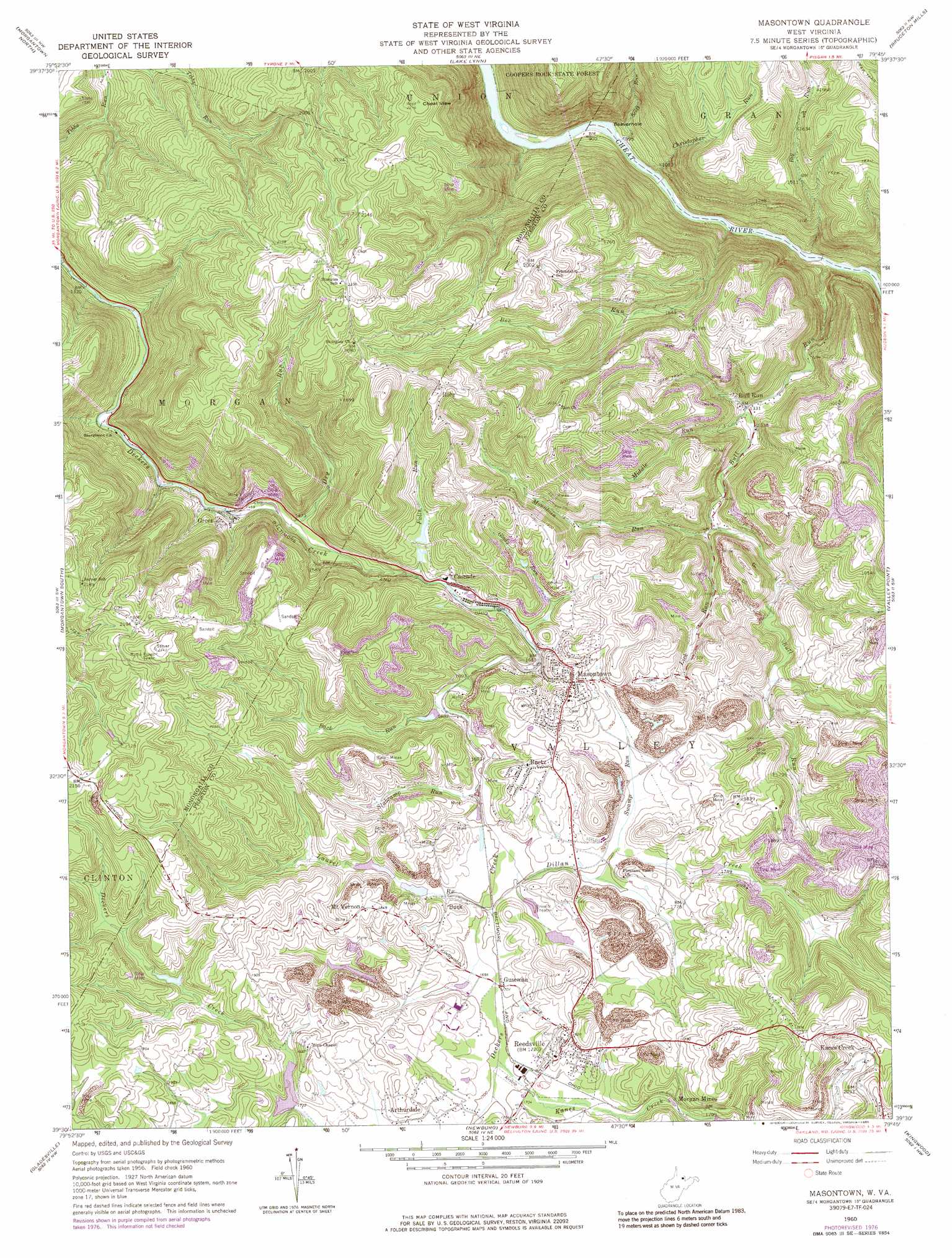
USGS Topo Quad 39079e7 - 1:24,000 scale
| Topo Map Name: | Masontown |
| USGS Topo Quad ID: | 39079e7 |
| Print Size: | ca. 21 1/4" wide x 27" high |
| Southeast Coordinates: | 39.5° N latitude / 79.75° W longitude |
| Map Center Coordinates: | 39.5625° N latitude / 79.8125° W longitude |
| U.S. State: | WV |
| Filename: | o39079e7.jpg |
| Download Map JPG Image: | Masontown topo map 1:24,000 scale |
| Map Type: | Topographic |
| Topo Series: | 7.5´ |
| Map Scale: | 1:24,000 |
| Source of Map Images: | United States Geological Survey (USGS) |
| Alternate Map Versions: |
Masontown WV 1960, updated 1961 Download PDF Buy paper map Masontown WV 1960, updated 1965 Download PDF Buy paper map Masontown WV 1960, updated 1977 Download PDF Buy paper map Masontown WV 1960, updated 1986 Download PDF Buy paper map Masontown WV 1960, updated 1998 Download PDF Buy paper map Masontown WV 1997, updated 2000 Download PDF Buy paper map Masontown WV 2011 Download PDF Buy paper map Masontown WV 2014 Download PDF Buy paper map Masontown WV 2016 Download PDF Buy paper map |
1:24,000 Topo Quads surrounding Masontown
Garards Fort |
Masontown |
Smithfield |
Brownfield |
Fort Necessity |
Osage |
Morgantown North |
Lake Lynn |
Bruceton Mills |
Brandonville |
Rivesville |
Morgantown South |
Masontown |
Valley Point |
Cuzzart |
Fairmont East |
Gladesville |
Newburg |
Kingwood |
Terra Alta |
Grafton |
Thornton |
Fellowsville |
Rowlesburg |
Aurora |
> Back to 39079e1 at 1:100,000 scale
> Back to 39078a1 at 1:250,000 scale
> Back to U.S. Topo Maps home
Masontown topo map: Gazetteer
Masontown: Bays
Beaverhole elevation 273m 895′Masontown: Dams
Preston County Light and Power Company Dam elevation 533m 1748′Preston County Light and Power Company Lake Number Two Dam elevation 559m 1833′
Town of Masontown Water Supply Dam elevation 546m 1791′
Upper Deckers Creek Structure Four Dam elevation 530m 1738′
Upper Deckers Creek Structure Number Five Dam elevation 533m 1748′
Upper Deckers Creek Structure Number One Dam elevation 524m 1719′
Upper Deckers Creek Structure Number Seven Dam elevation 519m 1702′
Upper Deckers Creek Structure Number Three Dam elevation 517m 1696′
Upper Deckers Creek Structure Number Two Dam elevation 521m 1709′
Masontown: Parks
Elkins Coal and Coke Company Historic District elevation 521m 1709′Snake Hill Wildlife Management Area elevation 649m 2129′
Upper Deckers Creek Wildlife Management Area elevation 519m 1702′
Masontown: Populated Places
Bretz elevation 551m 1807′Bull Run elevation 404m 1325′
Burk elevation 517m 1696′
Cascade elevation 519m 1702′
Greer elevation 446m 1463′
Guseman elevation 517m 1696′
Kanes Creek elevation 606m 1988′
Masontown elevation 549m 1801′
Mount Vernon elevation 569m 1866′
Reedsville elevation 554m 1817′
Rohr elevation 647m 2122′
Sturgisson elevation 430m 1410′
Masontown: Post Offices
Bretz Post Office elevation 552m 1811′Masontown: Reservoirs
Town of Masontown Water Supply D Lake elevation 546m 1791′Masontown: Springs
Frank Corbin Spring elevation 445m 1459′Maiden Spring elevation 469m 1538′
Mayfield Spring elevation 538m 1765′
Mayfield Spring elevation 678m 2224′
Ottie Mayfield Spring elevation 654m 2145′
Masontown: Streams
Back Run elevation 511m 1676′Bee Run elevation 268m 879′
Big Run elevation 276m 905′
Bull Run elevation 274m 898′
Christopher Run elevation 274m 898′
Dillan Creek elevation 513m 1683′
Dry Run elevation 442m 1450′
Falls Run elevation 511m 1676′
Glady Run elevation 509m 1669′
Kanes Creek elevation 517m 1696′
Laurel Run elevation 515m 1689′
Lick Run elevation 441m 1446′
Middle Run elevation 402m 1318′
Mountain Run elevation 430m 1410′
Scott Run elevation 267m 875′
Slabcamp Run elevation 513m 1683′
Swamp Run elevation 517m 1696′
Masontown: Summits
Cheat View elevation 675m 2214′Masontown digital topo map on disk
Buy this Masontown topo map showing relief, roads, GPS coordinates and other geographical features, as a high-resolution digital map file on DVD:
 map DVD")