Meyersdale Topo Map Pennsylvania
To zoom in, hover over the map of Meyersdale
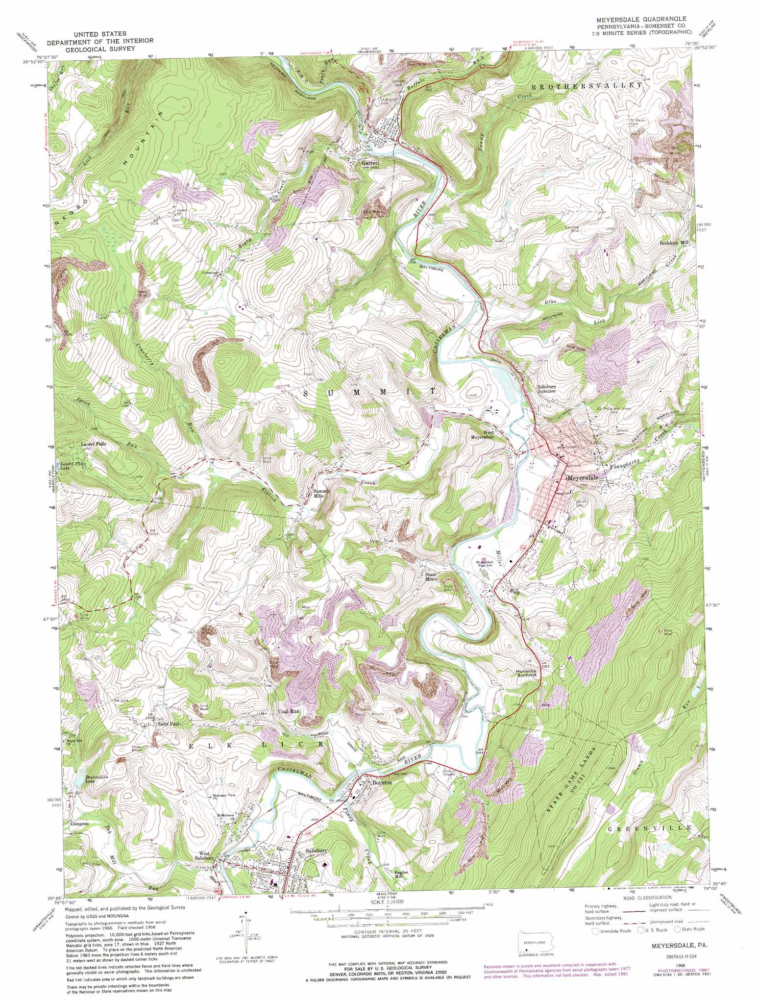
USGS Topo Quad 39079g1 - 1:24,000 scale
| Topo Map Name: | Meyersdale |
| USGS Topo Quad ID: | 39079g1 |
| Print Size: | ca. 21 1/4" wide x 27" high |
| Southeast Coordinates: | 39.75° N latitude / 79° W longitude |
| Map Center Coordinates: | 39.8125° N latitude / 79.0625° W longitude |
| U.S. State: | PA |
| Filename: | o39079g1.jpg |
| Download Map JPG Image: | Meyersdale topo map 1:24,000 scale |
| Map Type: | Topographic |
| Topo Series: | 7.5´ |
| Map Scale: | 1:24,000 |
| Source of Map Images: | United States Geological Survey (USGS) |
| Alternate Map Versions: |
Meyersdale PA 1968, updated 1972 Download PDF Buy paper map Meyersdale PA 1968, updated 1975 Download PDF Buy paper map Meyersdale PA 1968, updated 1982 Download PDF Buy paper map Meyersdale PA 1968, updated 1989 Download PDF Buy paper map Meyersdale PA 1977, updated 1979 Download PDF Buy paper map Meyersdale PA 2010 Download PDF Buy paper map Meyersdale PA 2013 Download PDF Buy paper map Meyersdale PA 2016 Download PDF Buy paper map |
1:24,000 Topo Quads surrounding Meyersdale
Seven Springs |
Bakersville |
Somerset |
Stoystown |
Central City |
Kingwood |
Rockwood |
Murdock |
Berlin |
New Baltimore |
Confluence |
Markleton |
Meyersdale |
Wittenberg |
Fairhope |
Accident |
Grantsville |
Avilton |
Frostburg |
Cumberland |
Mchenry |
Bittinger |
Barton |
Lonaconing |
Cresaptown |
> Back to 39079e1 at 1:100,000 scale
> Back to 39078a1 at 1:250,000 scale
> Back to U.S. Topo Maps home
Meyersdale topo map: Gazetteer
Meyersdale: Airports
Meyersdale Airport elevation 709m 2326′Meyersdale: Dams
Bigby Run Dam elevation 640m 2099′Meyersdale: Parks
State Game Lands Number 231 elevation 842m 2762′Meyersdale: Populated Places
Boynton elevation 606m 1988′Coal Run elevation 644m 2112′
Compton elevation 634m 2080′
Engles Mill elevation 625m 2050′
Garrett elevation 586m 1922′
Laurel Falls elevation 685m 2247′
Meyersdale elevation 605m 1984′
Romania elevation 595m 1952′
Saint Paul elevation 713m 2339′
Salisbury elevation 654m 2145′
Salisbury Junction elevation 624m 2047′
Shaw Mines elevation 618m 2027′
Summit Mills elevation 617m 2024′
West Meyersdale elevation 591m 1938′
West Salisbury elevation 611m 2004′
Meyersdale: Post Offices
Summit Post Office (historical) elevation 617m 2024′Meyersdale: Reservoirs
Bigby Run Lake elevation 640m 2099′Brenneman Lake elevation 649m 2129′
Laurel Falls Lake elevation 712m 2335′
Meyersdale: Streams
Bigby Creek elevation 584m 1916′Blue Lick Creek elevation 590m 1935′
Buffalo Creek elevation 590m 1935′
Cranberry Run elevation 619m 2030′
Elklick Creek elevation 588m 1929′
Flaugherty Creek elevation 591m 1938′
Meadow Run elevation 615m 2017′
Meadow Run elevation 609m 1998′
Miller Run elevation 592m 1942′
Piney Creek elevation 605m 1984′
Piney Creek elevation 628m 2060′
Piney Run elevation 579m 1899′
Spook Run elevation 634m 2080′
Swamp Creek elevation 591m 1938′
Tub Mill Run elevation 612m 2007′
Meyersdale: Summits
Hunsrick Summit elevation 690m 2263′Meyersdale: Valleys
Casselman Gorge elevation 584m 1916′Meyersdale digital topo map on disk
Buy this Meyersdale topo map showing relief, roads, GPS coordinates and other geographical features, as a high-resolution digital map file on DVD:
 map DVD")