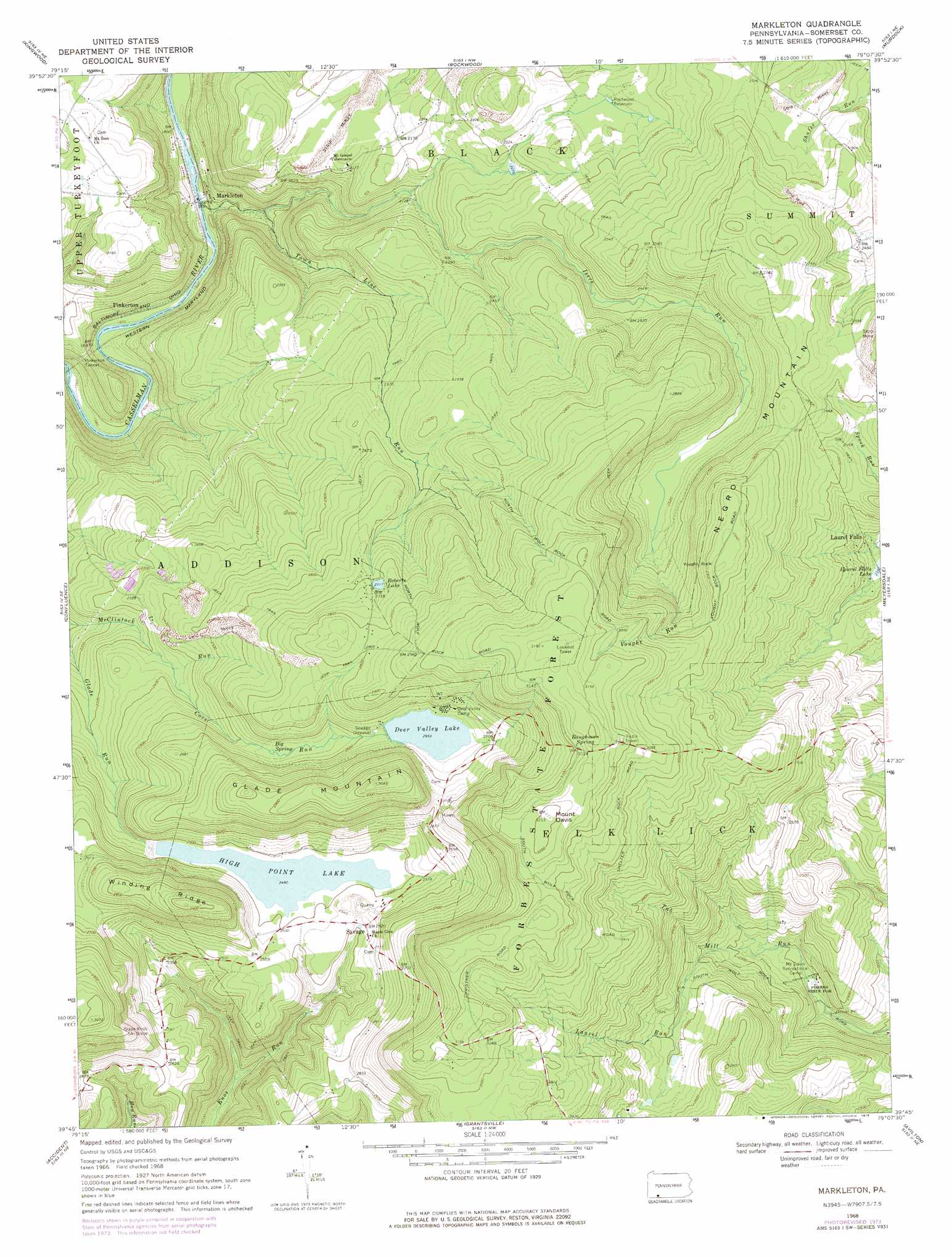
Markleton Topo Map Pennsylvania
To zoom in, hover over the map of Markleton
USGS Topo Quad 39079g2 - 1:24,000 scale
| Topo Map Name: | Markleton |
| USGS Topo Quad ID: | 39079g2 |
| Print Size: | ca. 21 1/4" wide x 27" high |
| Southeast Coordinates: | 39.75° N latitude / 79.125° W longitude |
| Map Center Coordinates: | 39.8125° N latitude / 79.1875° W longitude |
| U.S. State: | PA |
| Filename: | o39079g2.jpg |
| Download Map JPG Image: | Markleton topo map 1:24,000 scale |
| Map Type: | Topographic |
| Topo Series: | 7.5´ |
| Map Scale: | 1:24,000 |
| Source of Map Images: | United States Geological Survey (USGS) |
| Alternate Map Versions: |
Markleton PA 1968, updated 1972 Download PDF Buy paper map Markleton PA 1968, updated 1975 Download PDF Buy paper map Markleton PA 1977, updated 1979 Download PDF Buy paper map Markleton PA 2010 Download PDF Buy paper map Markleton PA 2013 Download PDF Buy paper map Markleton PA 2016 Download PDF Buy paper map |
1:24,000 Topo Quads surrounding Markleton
Donegal |
Seven Springs |
Bakersville |
Somerset |
Stoystown |
Mill Run |
Kingwood |
Rockwood |
Murdock |
Berlin |
Ohiopyle |
Confluence |
Markleton |
Meyersdale |
Wittenberg |
Friendsville |
Accident |
Grantsville |
Avilton |
Frostburg |
Sang Run |
Mchenry |
Bittinger |
Barton |
Lonaconing |
> Back to 39079e1 at 1:100,000 scale
> Back to 39078a1 at 1:250,000 scale
> Back to U.S. Topo Maps home
Markleton topo map: Gazetteer
Markleton: Airports
Mount Davis Airport elevation 687m 2253′Markleton: Areas
Mount Davis Natural Area elevation 945m 3100′Mount Davis Picnic Area elevation 951m 3120′
Markleton: Cliffs
Shelter Rocks elevation 903m 2962′Markleton: Dams
Cove Lake Dam elevation 810m 2657′High Point Lake Dam elevation 743m 2437′
Markleton: Falls
Laurel Falls elevation 732m 2401′Markleton: Forests
Forbes State Forest elevation 692m 2270′Markleton: Populated Places
Markleton elevation 517m 1696′Pinkerton elevation 526m 1725′
Savage elevation 769m 2522′
Markleton: Ranges
Negro Mountain elevation 978m 3208′Markleton: Reservoirs
Deer Valley Lake elevation 809m 2654′High Point Lake elevation 756m 2480′
Roberts Lake elevation 825m 2706′
Rockwood Reservoir elevation 718m 2355′
Markleton: Ridges
Winding Ridge elevation 860m 2821′Markleton: Springs
Baughman Spring elevation 958m 3143′Big Spring elevation 773m 2536′
Markleton: Streams
Cove Run elevation 717m 2352′Isers Run elevation 536m 1758′
Laurel Run elevation 706m 2316′
Town Line Run elevation 506m 1660′
Vought Run elevation 776m 2545′
Markleton: Summits
Baughman Rocks elevation 961m 3152′Glade Mountain elevation 936m 3070′
Mount Davis elevation 977m 3205′
Vought Rock elevation 898m 2946′
Markleton: Tunnels
Pinkerton Tunnel elevation 546m 1791′Markleton digital topo map on disk
Buy this Markleton topo map showing relief, roads, GPS coordinates and other geographical features, as a high-resolution digital map file on DVD:
 map DVD")