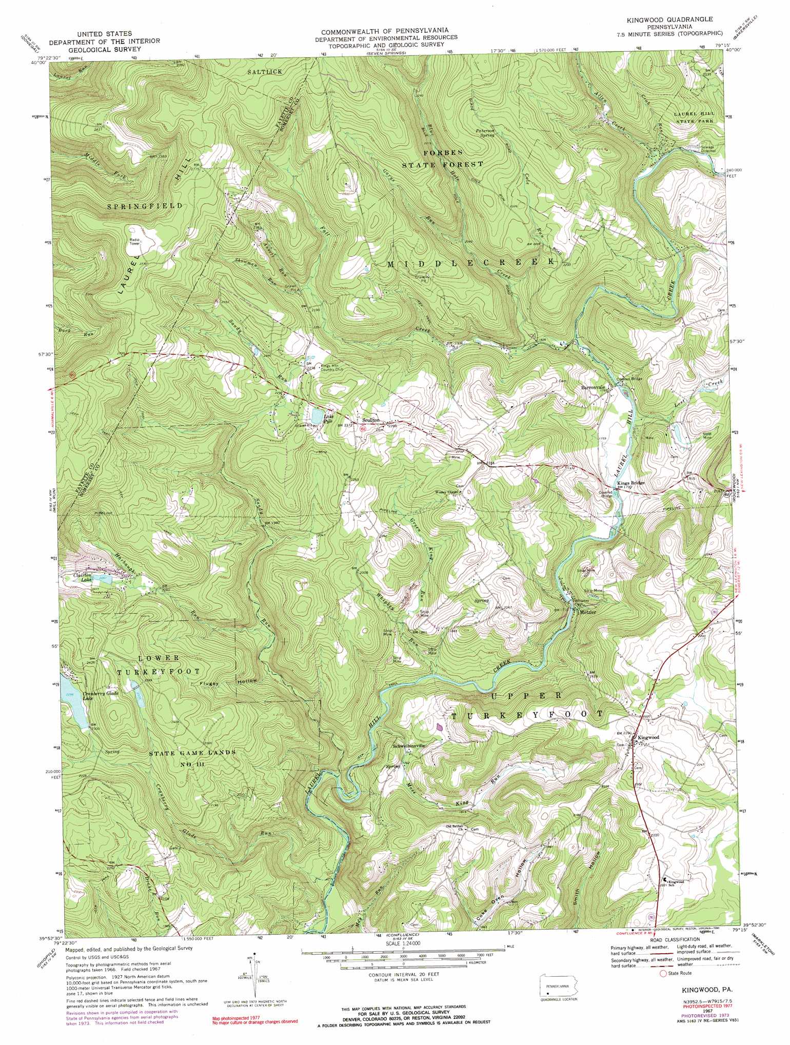
Kingwood Topo Map Pennsylvania
To zoom in, hover over the map of Kingwood
USGS Topo Quad 39079h3 - 1:24,000 scale
| Topo Map Name: | Kingwood |
| USGS Topo Quad ID: | 39079h3 |
| Print Size: | ca. 21 1/4" wide x 27" high |
| Southeast Coordinates: | 39.875° N latitude / 79.25° W longitude |
| Map Center Coordinates: | 39.9375° N latitude / 79.3125° W longitude |
| U.S. State: | PA |
| Filename: | o39079h3.jpg |
| Download Map JPG Image: | Kingwood topo map 1:24,000 scale |
| Map Type: | Topographic |
| Topo Series: | 7.5´ |
| Map Scale: | 1:24,000 |
| Source of Map Images: | United States Geological Survey (USGS) |
| Alternate Map Versions: |
Kingwood PA 1967, updated 1970 Download PDF Buy paper map Kingwood PA 1967, updated 1973 Download PDF Buy paper map Kingwood PA 1967, updated 1990 Download PDF Buy paper map Kingwood PA 1977, updated 1979 Download PDF Buy paper map Kingwood PA 1994, updated 1997 Download PDF Buy paper map Kingwood PA 2010 Download PDF Buy paper map Kingwood PA 2013 Download PDF Buy paper map Kingwood PA 2016 Download PDF Buy paper map |
1:24,000 Topo Quads surrounding Kingwood
Mount Pleasant |
Mammoth |
Stahlstown |
Ligonier |
Boswell |
Connellsville |
Donegal |
Seven Springs |
Bakersville |
Somerset |
South Connellsville |
Mill Run |
Kingwood |
Rockwood |
Murdock |
Fort Necessity |
Ohiopyle |
Confluence |
Markleton |
Meyersdale |
Brandonville |
Friendsville |
Accident |
Grantsville |
Avilton |
> Back to 39079e1 at 1:100,000 scale
> Back to 39078a1 at 1:250,000 scale
> Back to U.S. Topo Maps home
Kingwood topo map: Gazetteer
Kingwood: Dams
Cranberry Glade Dam elevation 700m 2296′Whipkey Dam elevation 524m 1719′
Kingwood: Falls
Cole Run Falls elevation 667m 2188′Kingwood: Lakes
Blue Hole elevation 624m 2047′Kingwood: Parks
Laural Ridge State Park elevation 798m 2618′Kingwood: Populated Places
Barronvale elevation 543m 1781′Kingwood elevation 696m 2283′
Metzler elevation 527m 1729′
Schweibinzville elevation 536m 1758′
Scullton elevation 705m 2312′
Kingwood: Reservoirs
Clairton Lake elevation 692m 2270′Cranberry Glade Lake elevation 700m 2296′
Lake Pyle elevation 703m 2306′
Kingwood: Springs
Blue Hole Spring elevation 619m 2030′Paterson Spring elevation 738m 2421′
Kingwood: Streams
Allen Creek elevation 587m 1925′Ansell Run elevation 659m 2162′
Blue Hole Creek elevation 559m 1833′
Cole Run elevation 588m 1929′
Crab Run elevation 591m 1938′
Cranberry Glade Run elevation 461m 1512′
Fall Creek elevation 546m 1791′
Garys Run elevation 627m 2057′
Green King Run elevation 560m 1837′
Harbaugh Run elevation 563m 1847′
Lost Creek elevation 543m 1781′
Mose King Run elevation 507m 1663′
Sandy Run elevation 487m 1597′
Showman Run elevation 666m 2185′
Whipkey Run elevation 513m 1683′
Kingwood: Valleys
Flugey Hollow elevation 556m 1824′Kingwood digital topo map on disk
Buy this Kingwood topo map showing relief, roads, GPS coordinates and other geographical features, as a high-resolution digital map file on DVD:
 map DVD")