Burnt House Topo Map West Virginia
To zoom in, hover over the map of Burnt House
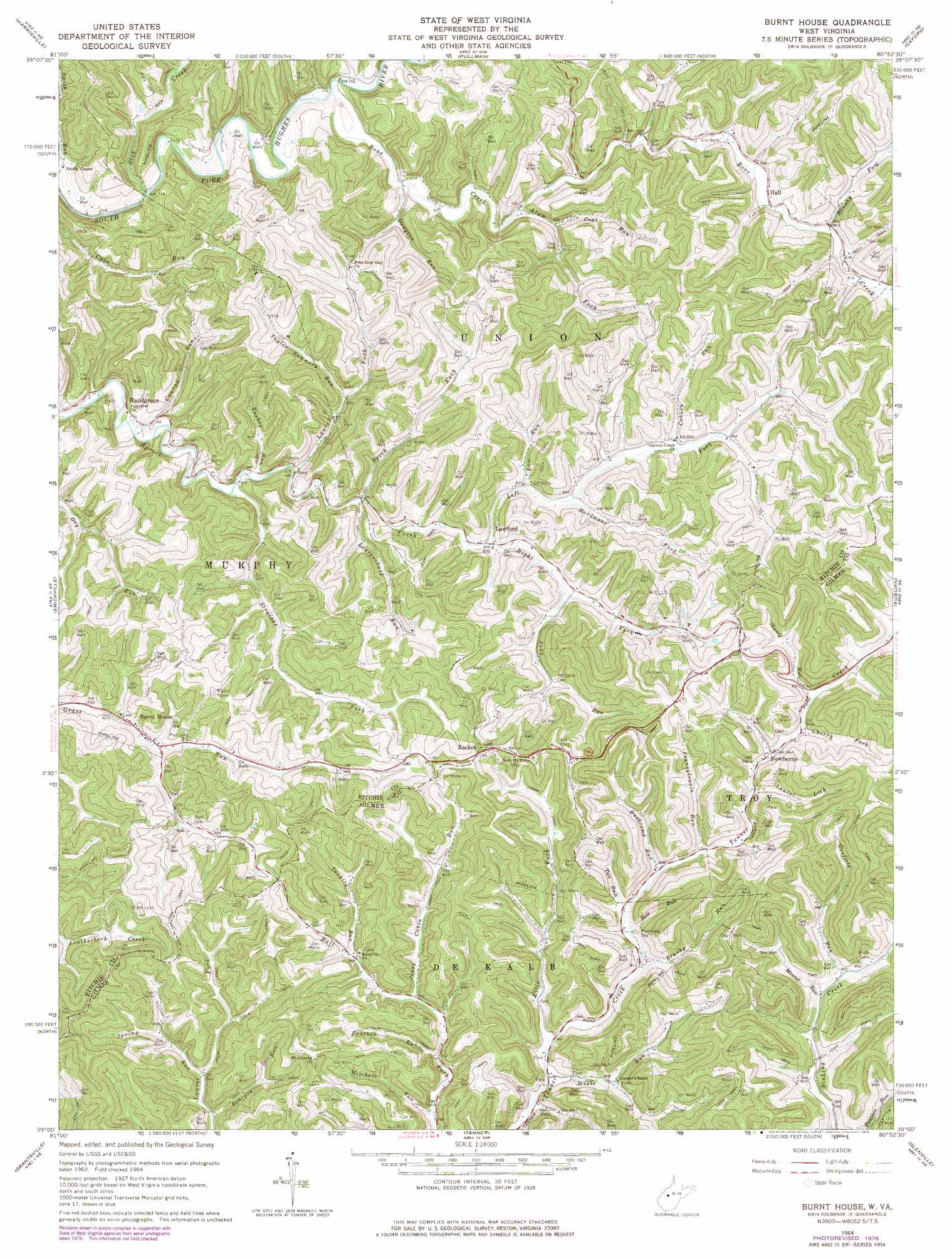
USGS Topo Quad 39080a8 - 1:24,000 scale
| Topo Map Name: | Burnt House |
| USGS Topo Quad ID: | 39080a8 |
| Print Size: | ca. 21 1/4" wide x 27" high |
| Southeast Coordinates: | 39° N latitude / 80.875° W longitude |
| Map Center Coordinates: | 39.0625° N latitude / 80.9375° W longitude |
| U.S. State: | WV |
| Filename: | o39080a8.jpg |
| Download Map JPG Image: | Burnt House topo map 1:24,000 scale |
| Map Type: | Topographic |
| Topo Series: | 7.5´ |
| Map Scale: | 1:24,000 |
| Source of Map Images: | United States Geological Survey (USGS) |
| Alternate Map Versions: |
Burnt House WV 1964, updated 1966 Download PDF Buy paper map Burnt House WV 1964, updated 1975 Download PDF Buy paper map Burnt House WV 1964, updated 1978 Download PDF Buy paper map Burnt House WV 2011 Download PDF Buy paper map Burnt House WV 2014 Download PDF Buy paper map Burnt House WV 2016 Download PDF Buy paper map |
1:24,000 Topo Quads surrounding Burnt House
Schultz |
Ellenboro |
Pennsboro |
West Union |
Smithburg |
Cairo |
Harrisville |
Pullman |
Oxford |
New Milton |
Macfarlan |
Smithville |
Burnt House |
Auburn |
Vadis |
Annamoriah |
Grantsville |
Tanner |
Glenville |
Gilmer |
Arnoldsburg |
Millstone |
Normantown |
Cedarville |
Burnsville |
> Back to 39080a1 at 1:100,000 scale
> Back to 39080a1 at 1:250,000 scale
> Back to U.S. Topo Maps home
Burnt House topo map: Gazetteer
Burnt House: Gaps
Pine Low Gap elevation 360m 1181′Burnt House: Populated Places
Burnt House elevation 249m 816′Hazelgreen elevation 231m 757′
Lawford elevation 251m 823′
Newberne elevation 263m 862′
Racket elevation 356m 1167′
Burnt House: Post Offices
Burnt House Post Office elevation 247m 810′Lawford Post Office (historical) elevation 249m 816′
Newberne Post Office elevation 264m 866′
Burnt House: Springs
William Spring elevation 270m 885′Burnt House: Streams
Alum Fork elevation 232m 761′Bearpen Run elevation 249m 816′
Beech Fork elevation 244m 800′
Bone Creek elevation 221m 725′
Brushy Fork elevation 241m 790′
Brushy Run elevation 246m 807′
Bushcamp Run elevation 253m 830′
Cherry Fork elevation 265m 869′
Coal Run elevation 238m 780′
Coburn Run elevation 258m 846′
Conrad Run elevation 226m 741′
Dungeon Run elevation 226m 741′
Ellis Fork elevation 238m 780′
Garfield Run elevation 249m 816′
Hardmans Fork elevation 253m 830′
Holt Run elevation 247m 810′
Jessie Run elevation 239m 784′
Jones Cabin Run elevation 250m 820′
Laurel Fork elevation 237m 777′
Laurel Lick elevation 260m 853′
Law Run elevation 252m 826′
Leatherbark Run elevation 243m 797′
Left Fork Spruce Creek elevation 248m 813′
Mitchell Run elevation 236m 774′
Mound Run elevation 247m 810′
Panther Run elevation 243m 797′
Pennsylvania Run elevation 255m 836′
Right Fork Spruce Creek elevation 248m 813′
Seng Run elevation 257m 843′
Shanty Run elevation 268m 879′
Slab Creek elevation 218m 715′
Spring Run elevation 254m 833′
Straight Fork elevation 233m 764′
Tarkiln Run elevation 260m 853′
Taylor Summers Run elevation 250m 820′
Turkey Run elevation 236m 774′
Two Run elevation 249m 816′
Burnt House digital topo map on disk
Buy this Burnt House topo map showing relief, roads, GPS coordinates and other geographical features, as a high-resolution digital map file on DVD:
 map DVD")