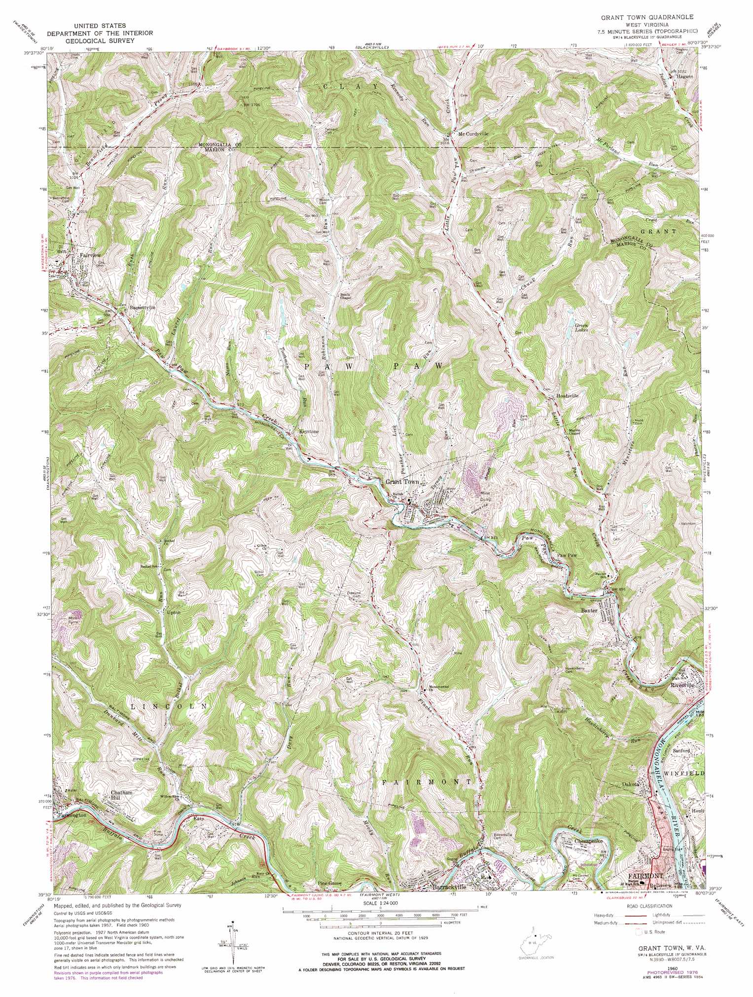
Grant Town Topo Map West Virginia
To zoom in, hover over the map of Grant Town
USGS Topo Quad 39080e2 - 1:24,000 scale
| Topo Map Name: | Grant Town |
| USGS Topo Quad ID: | 39080e2 |
| Print Size: | ca. 21 1/4" wide x 27" high |
| Southeast Coordinates: | 39.5° N latitude / 80.125° W longitude |
| Map Center Coordinates: | 39.5625° N latitude / 80.1875° W longitude |
| U.S. State: | WV |
| Filename: | o39080e2.jpg |
| Download Map JPG Image: | Grant Town topo map 1:24,000 scale |
| Map Type: | Topographic |
| Topo Series: | 7.5´ |
| Map Scale: | 1:24,000 |
| Source of Map Images: | United States Geological Survey (USGS) |
| Alternate Map Versions: |
Grant Town WV 1960, updated 1961 Download PDF Buy paper map Grant Town WV 1960, updated 1978 Download PDF Buy paper map Grant Town WV 1976, updated 1979 Download PDF Buy paper map Grant Town WV 2011 Download PDF Buy paper map Grant Town WV 2014 Download PDF Buy paper map Grant Town WV 2016 Download PDF Buy paper map |
1:24,000 Topo Quads surrounding Grant Town
New Freeport |
Holbrook |
Oak Forest |
Garards Fort |
Masontown |
Hundred |
Wadestown |
Blacksville |
Osage |
Morgantown North |
Glover Gap |
Mannington |
Grant Town |
Rivesville |
Morgantown South |
Wallace |
Shinnston |
Fairmont West |
Fairmont East |
Gladesville |
Wolf Summit |
Clarksburg |
Rosemont |
Grafton |
Thornton |
> Back to 39080e1 at 1:100,000 scale
> Back to 39080a1 at 1:250,000 scale
> Back to U.S. Topo Maps home
Grant Town topo map: Gazetteer
Grant Town: Bridges
Barrackville Covered Bridge elevation 270m 885′Grant Town: Dams
Conrad Dam elevation 363m 1190′Consol Number Nine Slurry Impoundment Dam elevation 359m 1177′
Grant Town: Populated Places
Barrackville elevation 288m 944′Basnettville elevation 303m 994′
Baxter elevation 272m 892′
Chatham Hill elevation 346m 1135′
Chesapeake elevation 291m 954′
Dakota elevation 288m 944′
Fairview elevation 305m 1000′
Farmington elevation 284m 931′
Grant Town elevation 301m 987′
Hagans elevation 317m 1040′
Hoodsville elevation 296m 971′
Hoult elevation 303m 994′
Katy elevation 292m 958′
Keystone elevation 295m 967′
McCurdyville elevation 310m 1017′
Paw Paw elevation 275m 902′
Pine Grove elevation 280m 918′
Sanford elevation 305m 1000′
Upton elevation 309m 1013′
Grant Town: Reservoirs
Barrackville Number 41 Lake elevation 365m 1197′Dogwood Lakes elevation 354m 1161′
Eastern Gas and Fuel Lake elevation 363m 1190′
Green Lakes elevation 333m 1092′
Mine Number Nine Slurry Impoundment elevation 359m 1177′
Grant Town: Springs
Basnettville Public Water Supply Spring elevation 300m 984′Edgar Ice Heirs Spring elevation 271m 889′
Grant Town: Streams
Arnett Run elevation 344m 1128′Bennefield Prong elevation 305m 1000′
Bethel Run elevation 288m 944′
Chunk Run elevation 295m 967′
Davy Run elevation 278m 912′
Dunkard Mill Run elevation 279m 915′
Finchs Run elevation 270m 885′
Hawkinberry Run elevation 262m 859′
Johnson Run elevation 276m 905′
Kennedy Run elevation 310m 1017′
Laurel Run elevation 297m 974′
Little Laurel Run elevation 281m 921′
Little Paw Paw Creek elevation 282m 925′
McFarland Run elevation 304m 997′
Ministers Run elevation 281m 921′
Nams Run elevation 296m 971′
Panther Lick Run elevation 286m 938′
Robinson Run elevation 287m 941′
Rush Run elevation 300m 984′
Shuman Run elevation 305m 1000′
Tarney Run elevation 282m 925′
Toothman Run elevation 290m 951′
Grant Town digital topo map on disk
Buy this Grant Town topo map showing relief, roads, GPS coordinates and other geographical features, as a high-resolution digital map file on DVD:
 map DVD")