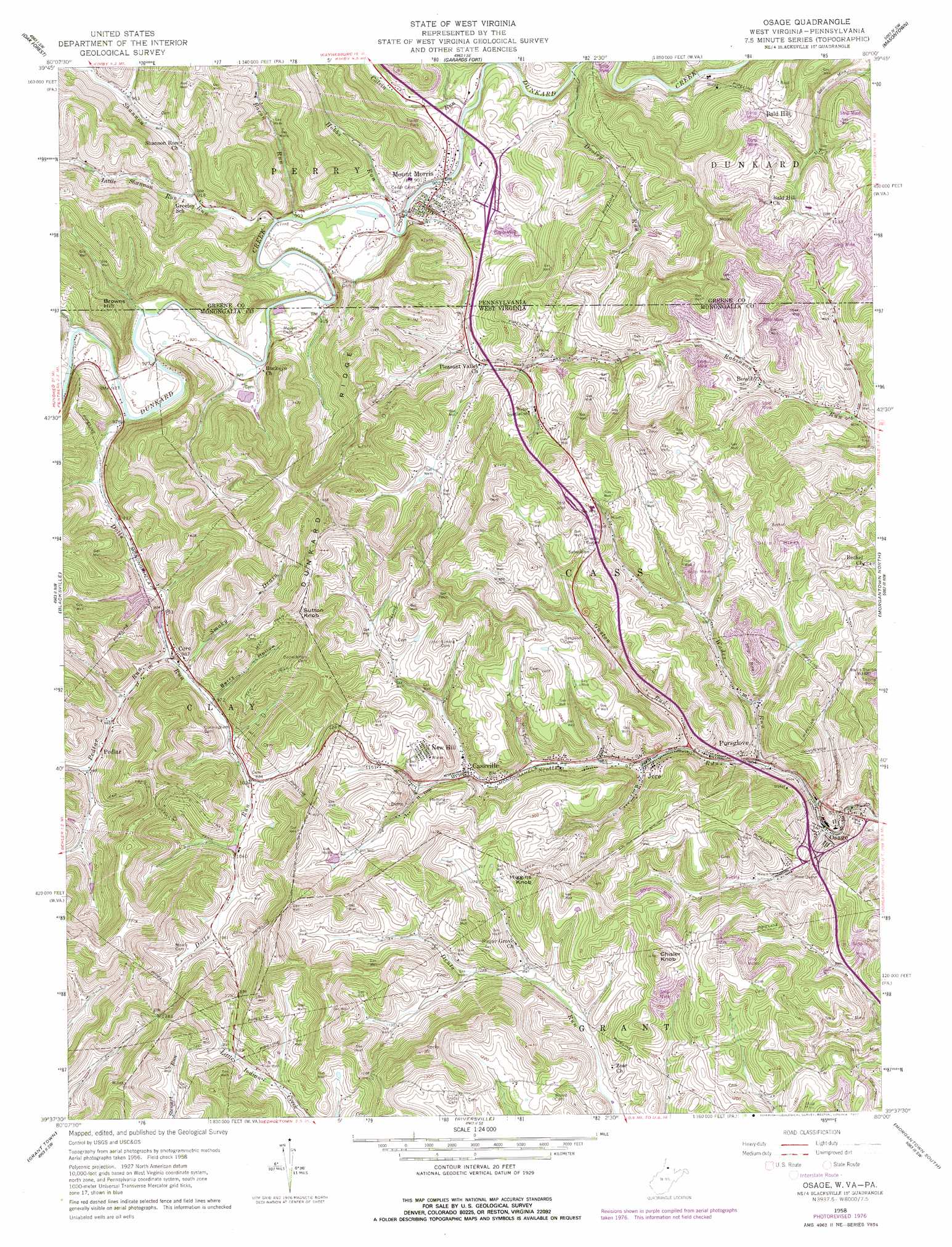
Osage Topo Map West Virginia
To zoom in, hover over the map of Osage
USGS Topo Quad 39080f1 - 1:24,000 scale
| Topo Map Name: | Osage |
| USGS Topo Quad ID: | 39080f1 |
| Print Size: | ca. 21 1/4" wide x 27" high |
| Southeast Coordinates: | 39.625° N latitude / 80° W longitude |
| Map Center Coordinates: | 39.6875° N latitude / 80.0625° W longitude |
| U.S. States: | WV, PA |
| Filename: | o39080f1.jpg |
| Download Map JPG Image: | Osage topo map 1:24,000 scale |
| Map Type: | Topographic |
| Topo Series: | 7.5´ |
| Map Scale: | 1:24,000 |
| Source of Map Images: | United States Geological Survey (USGS) |
| Alternate Map Versions: |
Osage WV 1958, updated 1961 Download PDF Buy paper map Osage WV 1958, updated 1970 Download PDF Buy paper map Osage WV 1958, updated 1977 Download PDF Buy paper map Osage WV 1976, updated 1979 Download PDF Buy paper map Osage WV 1997, updated 1999 Download PDF Buy paper map Osage WV 2011 Download PDF Buy paper map Osage WV 2014 Download PDF Buy paper map Osage WV 2016 Download PDF Buy paper map |
1:24,000 Topo Quads surrounding Osage
Rogersville |
Waynesburg |
Mather |
Carmichaels |
New Salem |
Holbrook |
Oak Forest |
Garards Fort |
Masontown |
Smithfield |
Wadestown |
Blacksville |
Osage |
Morgantown North |
Lake Lynn |
Mannington |
Grant Town |
Rivesville |
Morgantown South |
Masontown |
Shinnston |
Fairmont West |
Fairmont East |
Gladesville |
Newburg |
> Back to 39080e1 at 1:100,000 scale
> Back to 39080a1 at 1:250,000 scale
> Back to U.S. Topo Maps home
Osage topo map: Gazetteer
Osage: Crossings
Interchange 155 elevation 299m 980′Osage: Dams
Bailey A M D Treatment Facility Dam elevation 298m 977′Scotts Run Refuse Dam elevation 348m 1141′
Osage: Populated Places
Bald Hill elevation 366m 1200′Bowlby elevation 307m 1007′
Cassville elevation 305m 1000′
Core elevation 300m 984′
Fairchance elevation 280m 918′
Holman elevation 304m 997′
Jere elevation 286m 938′
Mount Morris elevation 286m 938′
New Hill elevation 367m 1204′
Osage elevation 266m 872′
Pedlar elevation 302m 990′
Pursglove elevation 282m 925′
Osage: Post Offices
Core Post Office elevation 290m 951′Pursglove Post Office elevation 283m 928′
Osage: Reservoirs
Arkwright-Sears Amd Pond elevation 346m 1135′Osage: Ridges
Dunkard Ridge elevation 423m 1387′Osage: Springs
Clarence Fetty Spring elevation 362m 1187′Frank O'Brad Spring elevation 321m 1053′
John Petrovich Spring elevation 394m 1292′
Ralph Tennant Spring elevation 316m 1036′
Stan McElroy Spring elevation 346m 1135′
Wade Spring elevation 353m 1158′
Osage: Streams
Bacon Run elevation 275m 902′Calvin Run elevation 270m 885′
Dolls Run elevation 276m 905′
Dooley Run elevation 274m 898′
Dooley Run elevation 269m 882′
Fox Run elevation 297m 974′
Guston Run elevation 287m 941′
Hobbs Run elevation 273m 895′
Little Shannon Run elevation 284m 931′
Pedlar Run elevation 290m 951′
Ripleys Run elevation 276m 905′
Shannon Run elevation 274m 898′
Smoky Drain elevation 290m 951′
Wades Run elevation 273m 895′
Watkins Run elevation 277m 908′
Osage: Summits
Browns Hill elevation 398m 1305′Browns Hill elevation 397m 1302′
Chisler Knob elevation 451m 1479′
Higgins Knob elevation 423m 1387′
Sutton Knob elevation 452m 1482′
Osage: Valleys
Berry Hollow elevation 297m 974′Osage digital topo map on disk
Buy this Osage topo map showing relief, roads, GPS coordinates and other geographical features, as a high-resolution digital map file on DVD:
 map DVD")