Cameron Topo Map West Virginia
To zoom in, hover over the map of Cameron
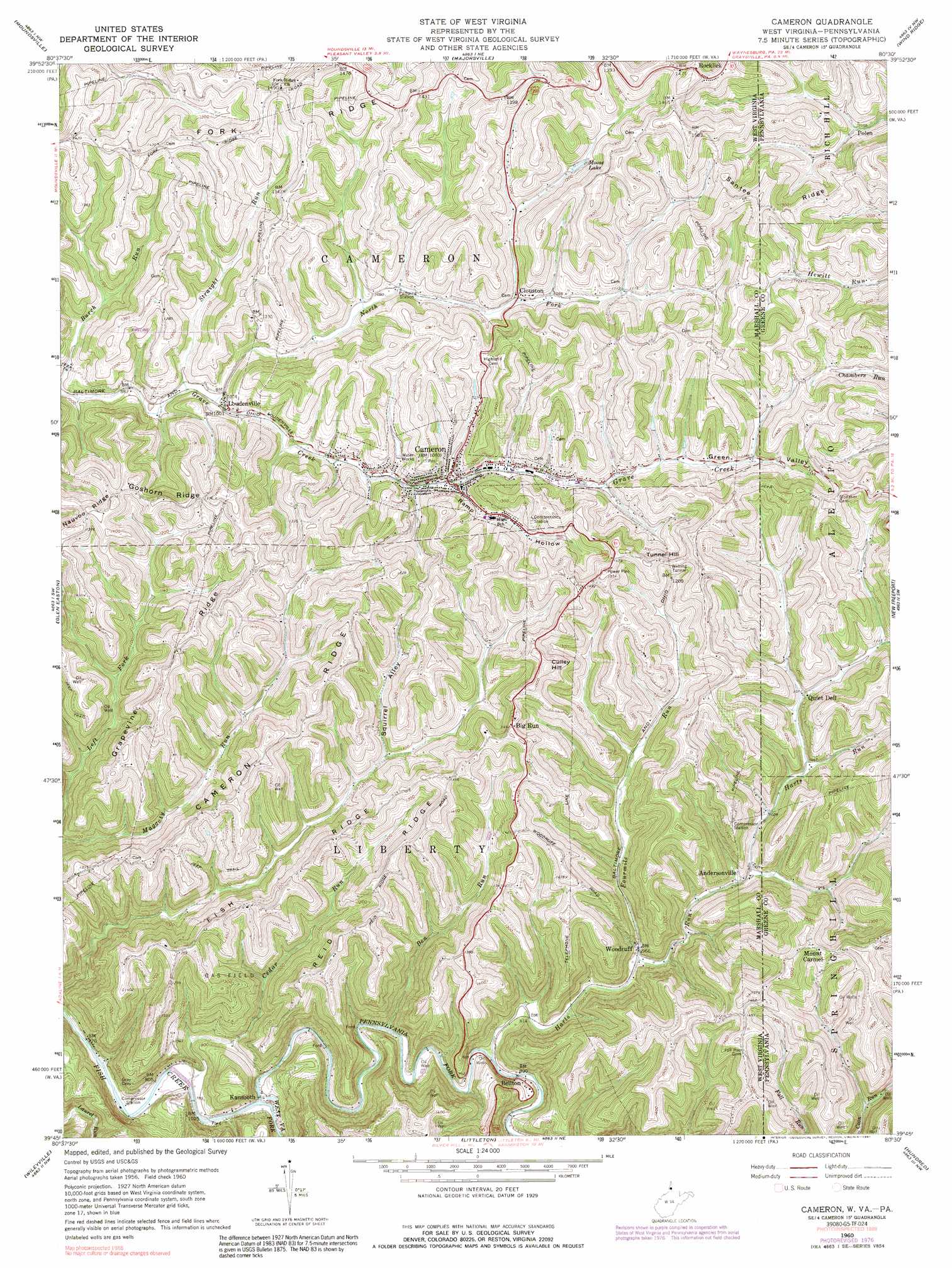
USGS Topo Quad 39080g5 - 1:24,000 scale
| Topo Map Name: | Cameron |
| USGS Topo Quad ID: | 39080g5 |
| Print Size: | ca. 21 1/4" wide x 27" high |
| Southeast Coordinates: | 39.75° N latitude / 80.5° W longitude |
| Map Center Coordinates: | 39.8125° N latitude / 80.5625° W longitude |
| U.S. States: | WV, PA |
| Filename: | o39080g5.jpg |
| Download Map JPG Image: | Cameron topo map 1:24,000 scale |
| Map Type: | Topographic |
| Topo Series: | 7.5´ |
| Map Scale: | 1:24,000 |
| Source of Map Images: | United States Geological Survey (USGS) |
| Alternate Map Versions: |
Cameron WV 1960, updated 1961 Download PDF Buy paper map Cameron WV 1960, updated 1966 Download PDF Buy paper map Cameron WV 1960, updated 1977 Download PDF Buy paper map Cameron WV 1960, updated 1991 Download PDF Buy paper map Cameron WV 2011 Download PDF Buy paper map Cameron WV 2014 Download PDF Buy paper map Cameron WV 2016 Download PDF Buy paper map |
1:24,000 Topo Quads surrounding Cameron
Lansing |
Wheeling |
Valley Grove |
Claysville |
Prosperity |
Businessburg |
Moundsville |
Majorsville |
Wind Ridge |
Rogersville |
Powhatan Point |
Glen Easton |
Cameron |
New Freeport |
Holbrook |
New Martinsville |
Wileyville |
Littleton |
Hundred |
Wadestown |
Porters Falls |
Pine Grove |
Big Run |
Glover Gap |
Mannington |
> Back to 39080e1 at 1:100,000 scale
> Back to 39080a1 at 1:250,000 scale
> Back to U.S. Topo Maps home
Cameron topo map: Gazetteer
Cameron: Dams
Upper Grave Creek Structure Number Eight Dam elevation 362m 1187′Upper Grave Creek Structure Number Five Dam elevation 363m 1190′
Upper Grave Creek Structure Number Four Dam elevation 378m 1240′
Upper Grave Creek Structure Number Nine Dam elevation 338m 1108′
Upper Grave Creek Structure Number One Dam elevation 332m 1089′
Upper Grave Creek Structure Number Seven Dam elevation 349m 1145′
Upper Grave Creek Structure Number Three Dam elevation 360m 1181′
Cameron: Populated Places
Andersonville elevation 304m 997′Bellton elevation 286m 938′
Big Run elevation 447m 1466′
Cameron elevation 325m 1066′
Clouston elevation 329m 1079′
Kausooth elevation 246m 807′
Loudenville elevation 315m 1033′
Mount Carmel elevation 435m 1427′
Polen elevation 325m 1066′
Quiet Dell elevation 327m 1072′
Rocklick elevation 449m 1473′
Wells (historical) elevation 300m 984′
Woodruff elevation 293m 961′
Cameron: Post Offices
Cameron Post Office elevation 321m 1053′Cameron: Reservoirs
Moose Lake elevation 357m 1171′Cameron: Ridges
Cameron Ridge elevation 433m 1420′Fish Ridge elevation 434m 1423′
Goshorn Ridge elevation 434m 1423′
Grapevine Ridge elevation 437m 1433′
Reid Ridge elevation 438m 1437′
Santee Ridge elevation 426m 1397′
Santee Ridge elevation 462m 1515′
Cameron: Springs
George Wahl Spring elevation 448m 1469′James E Blake Spring elevation 342m 1122′
Joseph Shepherd Spring elevation 417m 1368′
Cameron: Streams
Ben Run elevation 254m 833′Cedar Run elevation 235m 770′
Fourmile Run elevation 291m 954′
Harts Run elevation 266m 872′
North Fork Grave Creek elevation 303m 994′
Pennsylvania Fork Fish Creek elevation 238m 780′
Pennsylvania Fork Fish Creek elevation 238m 780′
Straight Run elevation 302m 990′
West Virginia Fork Fish Creek elevation 238m 780′
Cameron: Summits
Culley Hill elevation 475m 1558′Tunnel Hill elevation 453m 1486′
Cameron: Valleys
Green Valley elevation 334m 1095′Green Valley elevation 347m 1138′
Ramp Hollow elevation 325m 1066′
Squirrel Alley elevation 323m 1059′
Cameron digital topo map on disk
Buy this Cameron topo map showing relief, roads, GPS coordinates and other geographical features, as a high-resolution digital map file on DVD:
 map DVD")