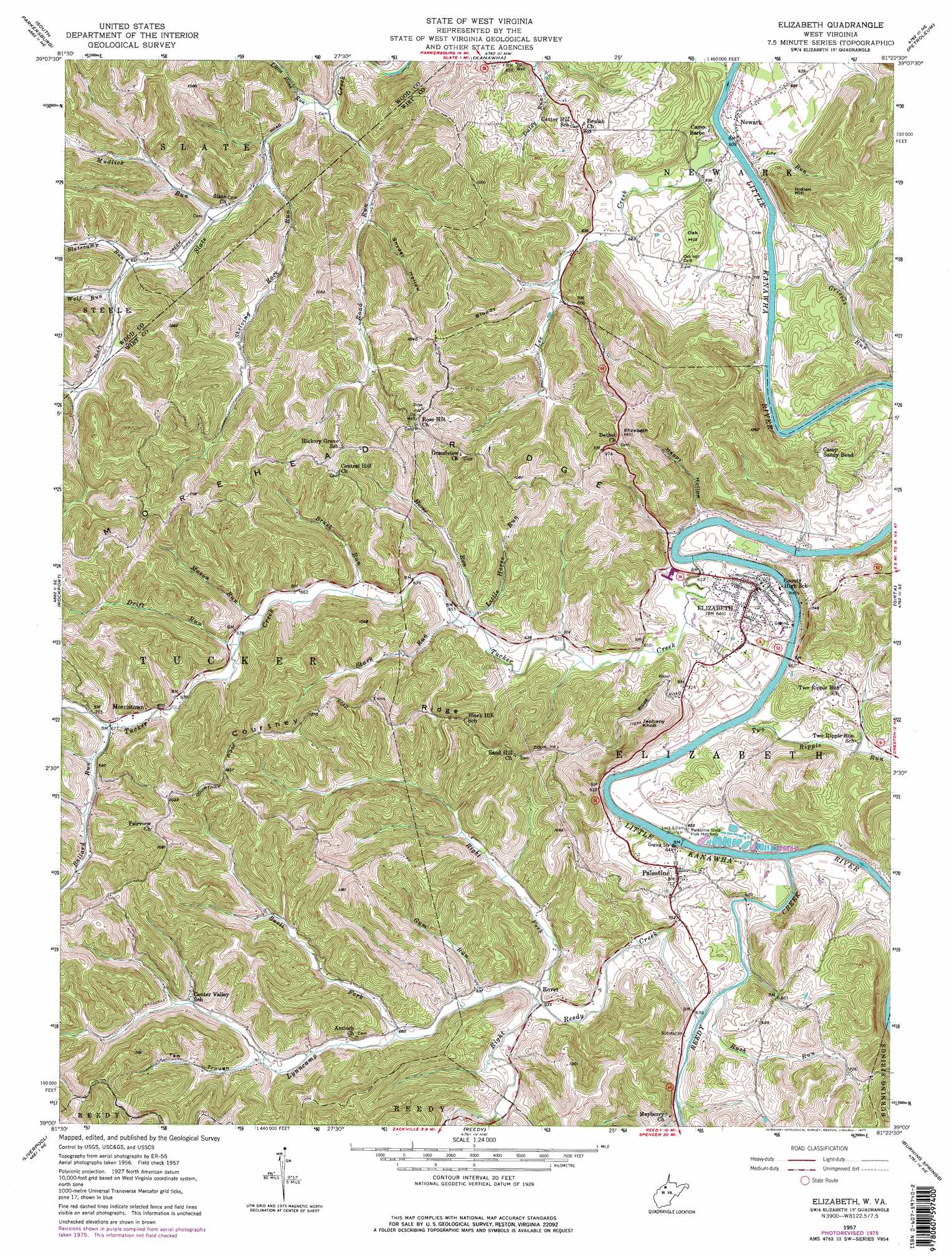
Elizabeth Topo Map West Virginia
To zoom in, hover over the map of Elizabeth
USGS Topo Quad 39081a4 - 1:24,000 scale
| Topo Map Name: | Elizabeth |
| USGS Topo Quad ID: | 39081a4 |
| Print Size: | ca. 21 1/4" wide x 27" high |
| Southeast Coordinates: | 39° N latitude / 81.375° W longitude |
| Map Center Coordinates: | 39.0625° N latitude / 81.4375° W longitude |
| U.S. State: | WV |
| Filename: | o39081a4.jpg |
| Download Map JPG Image: | Elizabeth topo map 1:24,000 scale |
| Map Type: | Topographic |
| Topo Series: | 7.5´ |
| Map Scale: | 1:24,000 |
| Source of Map Images: | United States Geological Survey (USGS) |
| Alternate Map Versions: |
Elizabeth WV 1957, updated 1958 Download PDF Buy paper map Elizabeth WV 1957, updated 1977 Download PDF Buy paper map Elizabeth WV 2010 Download PDF Buy paper map Elizabeth WV 2014 Download PDF Buy paper map Elizabeth WV 2016 Download PDF Buy paper map |
1:24,000 Topo Quads surrounding Elizabeth
Little Hocking |
Parkersburg |
Valley Mills |
Willow Island |
Schultz |
Lubeck |
South Parkersburg |
Kanawha |
Petroleum |
Cairo |
Pond Creek |
Rockport |
Elizabeth |
Girta |
Macfarlan |
Sandyville |
Liverpool |
Reedy |
Burning Springs |
Annamoriah |
Ripley |
Gay |
Peniel |
Spencer |
Arnoldsburg |
> Back to 39081a1 at 1:100,000 scale
> Back to 39080a1 at 1:250,000 scale
> Back to U.S. Topo Maps home
Elizabeth topo map: Gazetteer
Elizabeth: Bends
Sandy Bend elevation 179m 587′Elizabeth: Dams
Lock and Dam Number 4 elevation 185m 606′Elizabeth: Populated Places
Beulah Hill elevation 244m 800′Elizabeth elevation 197m 646′
Kingbury (historical) elevation 190m 623′
Morristown elevation 207m 679′
Newark elevation 196m 643′
Palestine elevation 208m 682′
Rover elevation 196m 643′
Standingstone (historical) elevation 207m 679′
Elizabeth: Post Offices
Newark Post Office elevation 191m 626′Palestine Post Office elevation 208m 682′
Elizabeth: Ridges
Courtney Ridge elevation 330m 1082′Morehead Ridge elevation 324m 1062′
Elizabeth: Streams
Ballard Run elevation 205m 672′Bennett Run elevation 213m 698′
Brush Run elevation 196m 643′
Buell Fork elevation 197m 646′
Drift Run elevation 198m 649′
Grieves Run elevation 178m 583′
Gum Run elevation 191m 626′
Horse Run elevation 193m 633′
Lee Creek elevation 182m 597′
Lee Run elevation 178m 583′
Little Horse Run elevation 193m 633′
Little Road Run elevation 187m 613′
Lynncamp Run elevation 188m 616′
Mason Run elevation 199m 652′
Mudlick Run elevation 188m 616′
Reedy Creek elevation 185m 606′
Right Fork Lynncamp Run elevation 190m 623′
Right Reedy Creek elevation 185m 606′
Road Run elevation 185m 606′
Rush Run elevation 185m 606′
Sergeant Run elevation 193m 633′
Shelving Rock Run elevation 189m 620′
Slatecamp Run elevation 193m 633′
Stark Run elevation 193m 633′
Tucker Creek elevation 184m 603′
Two Ripple Run elevation 184m 603′
Wolf Run elevation 195m 639′
Elizabeth: Summits
Elizabeth Hill elevation 321m 1053′Indian Hill elevation 304m 997′
Jephany Knob elevation 336m 1102′
Oak Hill elevation 224m 734′
Elizabeth: Valleys
Bloody Hollow elevation 199m 652′Happy Hollow elevation 198m 649′
Snyder Hollow elevation 201m 659′
Tan Trough elevation 212m 695′
Elizabeth digital topo map on disk
Buy this Elizabeth topo map showing relief, roads, GPS coordinates and other geographical features, as a high-resolution digital map file on DVD:
 map DVD")