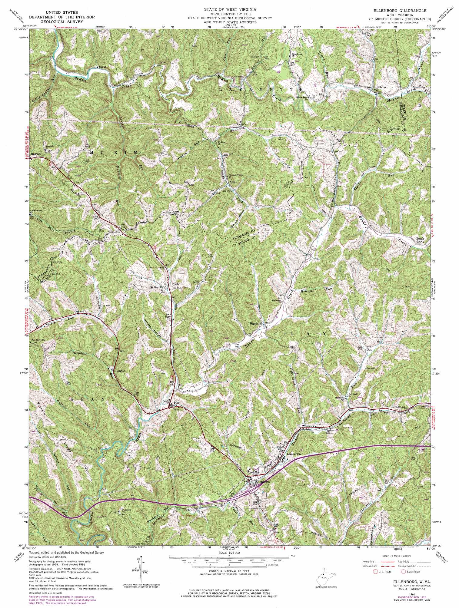
Ellenboro Topo Map West Virginia
To zoom in, hover over the map of Ellenboro
USGS Topo Quad 39081c1 - 1:24,000 scale
| Topo Map Name: | Ellenboro |
| USGS Topo Quad ID: | 39081c1 |
| Print Size: | ca. 21 1/4" wide x 27" high |
| Southeast Coordinates: | 39.25° N latitude / 81° W longitude |
| Map Center Coordinates: | 39.3125° N latitude / 81.0625° W longitude |
| U.S. State: | WV |
| Filename: | o39081c1.jpg |
| Download Map JPG Image: | Ellenboro topo map 1:24,000 scale |
| Map Type: | Topographic |
| Topo Series: | 7.5´ |
| Map Scale: | 1:24,000 |
| Source of Map Images: | United States Geological Survey (USGS) |
| Alternate Map Versions: |
Ellenboro WV 1961, updated 1962 Download PDF Buy paper map Ellenboro WV 1961, updated 1968 Download PDF Buy paper map Ellenboro WV 1961, updated 1977 Download PDF Buy paper map Ellenboro WV 1975, updated 1979 Download PDF Buy paper map Ellenboro WV 2010 Download PDF Buy paper map Ellenboro WV 2014 Download PDF Buy paper map Ellenboro WV 2016 Download PDF Buy paper map |
1:24,000 Topo Quads surrounding Ellenboro
Dalzell |
Rinard Mills |
New Matamoras |
Paden City |
Porters Falls |
Belmont |
Raven Rock |
Bens Run |
Middlebourne |
Shirley |
Willow Island |
Schultz |
Ellenboro |
Pennsboro |
West Union |
Petroleum |
Cairo |
Harrisville |
Pullman |
Oxford |
Girta |
Macfarlan |
Smithville |
Burnt House |
Auburn |
> Back to 39081a1 at 1:100,000 scale
> Back to 39080a1 at 1:250,000 scale
> Back to U.S. Topo Maps home
Ellenboro topo map: Gazetteer
Ellenboro: Populated Places
Adlai elevation 244m 800′Admiral (historical) elevation 247m 810′
Beech Grove elevation 254m 833′
Briggs elevation 293m 961′
Crisp (historical) elevation 206m 675′
Ellenboro elevation 247m 810′
Fern elevation 243m 797′
Finch elevation 255m 836′
Hebron elevation 231m 757′
Highland elevation 240m 787′
Lamberton elevation 242m 793′
League elevation 242m 793′
Pike elevation 246m 807′
Pine Grove elevation 255m 836′
Ellenboro: Post Offices
Ellenboro Post Office elevation 236m 774′Hebron Post Office elevation 231m 757′
Highland Post Office elevation 241m 790′
Ellenboro: Ridges
Pigskin Ridge elevation 348m 1141′Ellenboro: Streams
Beech Run elevation 251m 823′Big Knot Run elevation 246m 807′
Blacks Run elevation 245m 803′
Brush Run elevation 231m 757′
Cave Run elevation 211m 692′
Comfort Run elevation 229m 751′
Grimes Run elevation 226m 741′
Hitchcock Run elevation 242m 793′
Hogpen Run elevation 226m 741′
Irish Run elevation 235m 770′
Little Painter Run elevation 239m 784′
Little Panther Run elevation 192m 629′
McGregor Run elevation 242m 793′
Mudlick Run elevation 231m 757′
Painter Run elevation 228m 748′
Panther Run elevation 201m 659′
Rock Run elevation 206m 675′
South Fork Rock Run elevation 233m 764′
Walnut Run elevation 214m 702′
Whiskey Run elevation 232m 761′
Wolfpen Run elevation 226m 741′
Ellenboro: Valleys
Brooks Hollow elevation 245m 803′Church Hollow elevation 264m 866′
Ellenboro digital topo map on disk
Buy this Ellenboro topo map showing relief, roads, GPS coordinates and other geographical features, as a high-resolution digital map file on DVD:
 map DVD")