Little Hocking Topo Map Ohio
To zoom in, hover over the map of Little Hocking
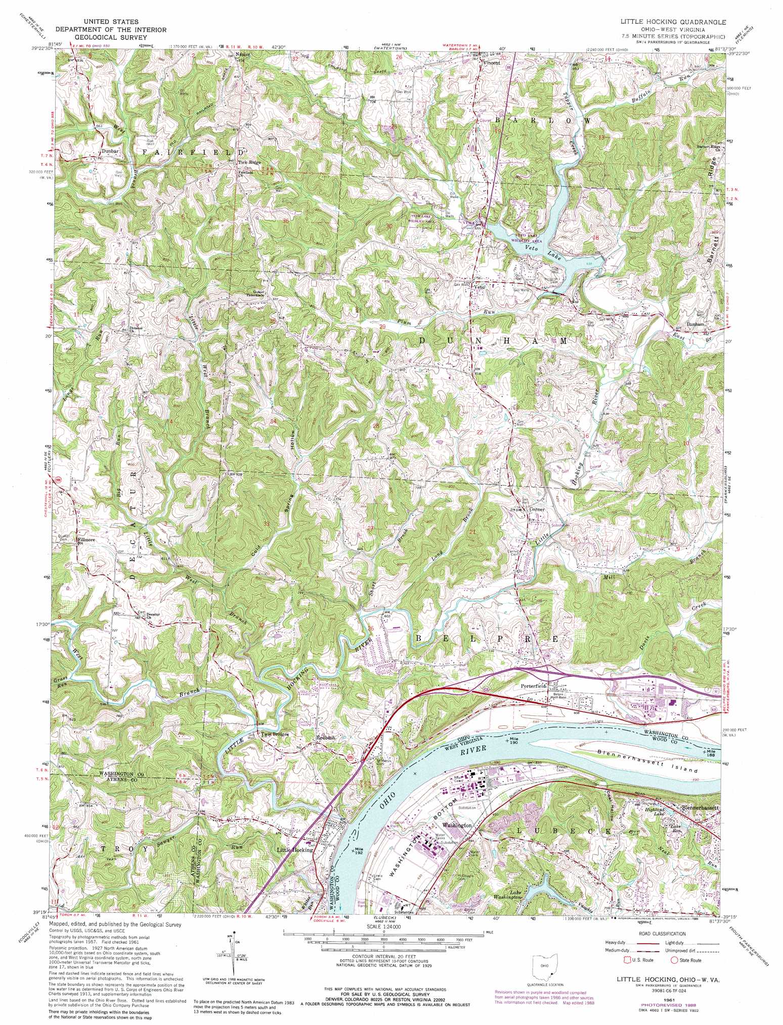
USGS Topo Quad 39081c6 - 1:24,000 scale
| Topo Map Name: | Little Hocking |
| USGS Topo Quad ID: | 39081c6 |
| Print Size: | ca. 21 1/4" wide x 27" high |
| Southeast Coordinates: | 39.25° N latitude / 81.625° W longitude |
| Map Center Coordinates: | 39.3125° N latitude / 81.6875° W longitude |
| U.S. States: | OH, WV |
| Filename: | o39081c6.jpg |
| Download Map JPG Image: | Little Hocking topo map 1:24,000 scale |
| Map Type: | Topographic |
| Topo Series: | 7.5´ |
| Map Scale: | 1:24,000 |
| Source of Map Images: | United States Geological Survey (USGS) |
| Alternate Map Versions: |
Little Hocking OH 1961, updated 1963 Download PDF Buy paper map Little Hocking OH 1961, updated 1973 Download PDF Buy paper map Little Hocking OH 1961, updated 1977 Download PDF Buy paper map Little Hocking OH 1961, updated 1989 Download PDF Buy paper map Little Hocking OH 1994, updated 1998 Download PDF Buy paper map Little Hocking OH 2010 Download PDF Buy paper map Little Hocking OH 2013 Download PDF Buy paper map Little Hocking OH 2016 Download PDF Buy paper map |
1:24,000 Topo Quads surrounding Little Hocking
Ringgold |
Stockport |
Beverly |
Lowell |
Lower Salem |
Amesville |
Chesterhill |
Watertown |
Fleming |
Marietta |
Stewart |
Cutler |
Little Hocking |
Parkersburg |
Valley Mills |
Alfred |
Coolville |
Lubeck |
South Parkersburg |
Kanawha |
Chester |
Portland |
Pond Creek |
Rockport |
Elizabeth |
> Back to 39081a1 at 1:100,000 scale
> Back to 39080a1 at 1:250,000 scale
> Back to U.S. Topo Maps home
Little Hocking topo map: Gazetteer
Little Hocking: Bends
Washington Bottom elevation 192m 629′Little Hocking: Dams
Lake Washington Dam elevation 230m 754′Lock and Dam Number 19 elevation 178m 583′
Lock and Dam Number 19 (historical) elevation 178m 583′
Ohio Power Company Dam Number Three elevation 256m 839′
Veto Lake Dam elevation 196m 643′
Little Hocking: Islands
Blennerhassett Island elevation 180m 590′Little Hocking: Parks
Blennerhassett Island Historical State Park elevation 180m 590′Veto Lake Wildlife Area elevation 192m 629′
Little Hocking: Populated Places
Blennerhassett elevation 238m 780′Corner elevation 210m 688′
Dunbar elevation 231m 757′
Dunham elevation 198m 649′
Fillmore elevation 245m 803′
Little Hocking elevation 194m 636′
Napier elevation 248m 813′
Porterfield elevation 192m 629′
Redbush elevation 230m 754′
Tick Ridge elevation 287m 941′
Veto elevation 231m 757′
Washington elevation 196m 643′
Little Hocking: Reservoirs
Highland Lake elevation 235m 770′Lake Ron elevation 226m 741′
Lake Washington elevation 211m 692′
Ohio Power Pond Number Three elevation 256m 839′
Veto Lake elevation 196m 643′
Little Hocking: Ridges
Barnett Ridge elevation 264m 866′Little Hocking: Streams
Big Run elevation 189m 620′Buffalo Run elevation 197m 646′
Davis Creek elevation 180m 590′
East Branch Little Hocking River elevation 184m 603′
Grass Run elevation 182m 597′
Little Hocking River elevation 178m 583′
Little West Branch Little Hocking River elevation 180m 590′
Long Brook elevation 180m 590′
Mill Branch elevation 182m 597′
Plum Run elevation 195m 639′
Sawyer Run elevation 178m 583′
Short Brook elevation 180m 590′
Tupper Creek elevation 195m 639′
West Branch Little Hocking River elevation 181m 593′
Whites Run elevation 178m 583′
Little Hocking: Valleys
Coal Hollow elevation 191m 626′Cold Spring Hollow elevation 180m 590′
Little Hocking digital topo map on disk
Buy this Little Hocking topo map showing relief, roads, GPS coordinates and other geographical features, as a high-resolution digital map file on DVD:
 map DVD")