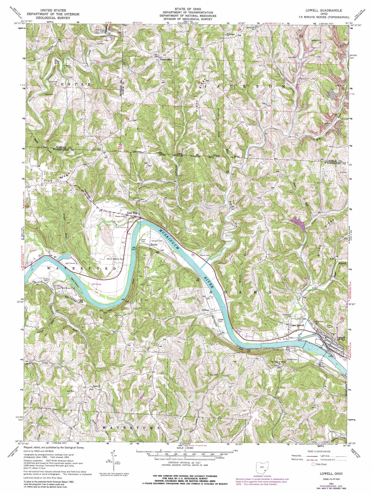
Lowell Topo Map Ohio
To zoom in, hover over the map of Lowell
USGS Topo Quad 39081e5 - 1:24,000 scale
| Topo Map Name: | Lowell |
| USGS Topo Quad ID: | 39081e5 |
| Print Size: | ca. 21 1/4" wide x 27" high |
| Southeast Coordinates: | 39.5° N latitude / 81.5° W longitude |
| Map Center Coordinates: | 39.5625° N latitude / 81.5625° W longitude |
| U.S. State: | OH |
| Filename: | o39081e5.jpg |
| Download Map JPG Image: | Lowell topo map 1:24,000 scale |
| Map Type: | Topographic |
| Topo Series: | 7.5´ |
| Map Scale: | 1:24,000 |
| Source of Map Images: | United States Geological Survey (USGS) |
| Alternate Map Versions: |
Lowell OH 1961, updated 1962 Download PDF Buy paper map Lowell OH 1961, updated 1973 Download PDF Buy paper map Lowell OH 1961, updated 1976 Download PDF Buy paper map Lowell OH 1961, updated 1988 Download PDF Buy paper map Lowell OH 1994, updated 1998 Download PDF Buy paper map Lowell OH 2010 Download PDF Buy paper map Lowell OH 2013 Download PDF Buy paper map Lowell OH 2016 Download PDF Buy paper map |
1:24,000 Topo Quads surrounding Lowell
Ruraldale |
Cumberland |
Caldwell North |
Sarahsville |
Summerfield |
Mcconnelsville |
Reinersville |
Caldwell South |
Macksburg |
Stafford |
Stockport |
Beverly |
Lowell |
Lower Salem |
Dalzell |
Chesterhill |
Watertown |
Fleming |
Marietta |
Belmont |
Cutler |
Little Hocking |
Parkersburg |
Valley Mills |
Willow Island |
> Back to 39081e1 at 1:100,000 scale
> Back to 39080a1 at 1:250,000 scale
> Back to U.S. Topo Maps home
Lowell topo map: Gazetteer
Lowell: Airports
Checkpoint Charlie Airport elevation 201m 659′Lakeside Resort Colony Airport elevation 192m 629′
Lowell: Dams
Lakeside Motel Pond Dam elevation 198m 649′Muskingum River Lock and Dam Number Three elevation 182m 597′
Strahler Pond Dam elevation 239m 784′
Lowell: Flats
Federal Bottom elevation 194m 636′Lowell: Islands
Dana Island elevation 189m 620′Lowell: Populated Places
Clifton elevation 191m 626′Coal Run elevation 198m 649′
Dungannon elevation 300m 984′
Equity elevation 201m 659′
Lowell elevation 188m 616′
Lowell Trailer Park elevation 184m 603′
Upper Lowell elevation 209m 685′
Lowell: Reservoirs
Lakeside Motel Pond elevation 198m 649′Muskingum River Lock and Dam Number elevation 182m 597′
Strahler Pond elevation 239m 784′
Lowell: Ridges
Hibbs Ridge elevation 293m 961′Tick Ridge elevation 281m 921′
Lowell: Streams
Bear Run elevation 203m 666′Big Run elevation 180m 590′
Cat Creek elevation 183m 600′
Congress Run elevation 188m 616′
Culver Run elevation 200m 656′
Cushing Run elevation 184m 603′
Little Cold Run elevation 199m 652′
Mason Run elevation 189m 620′
Reasoners Run elevation 207m 679′
Right Branch Cat Creek elevation 189m 620′
Stong Creek elevation 196m 643′
Stony Creek elevation 194m 636′
Straight Run elevation 198m 649′
Sugar Run elevation 198m 649′
Lowell digital topo map on disk
Buy this Lowell topo map showing relief, roads, GPS coordinates and other geographical features, as a high-resolution digital map file on DVD:
 map DVD")