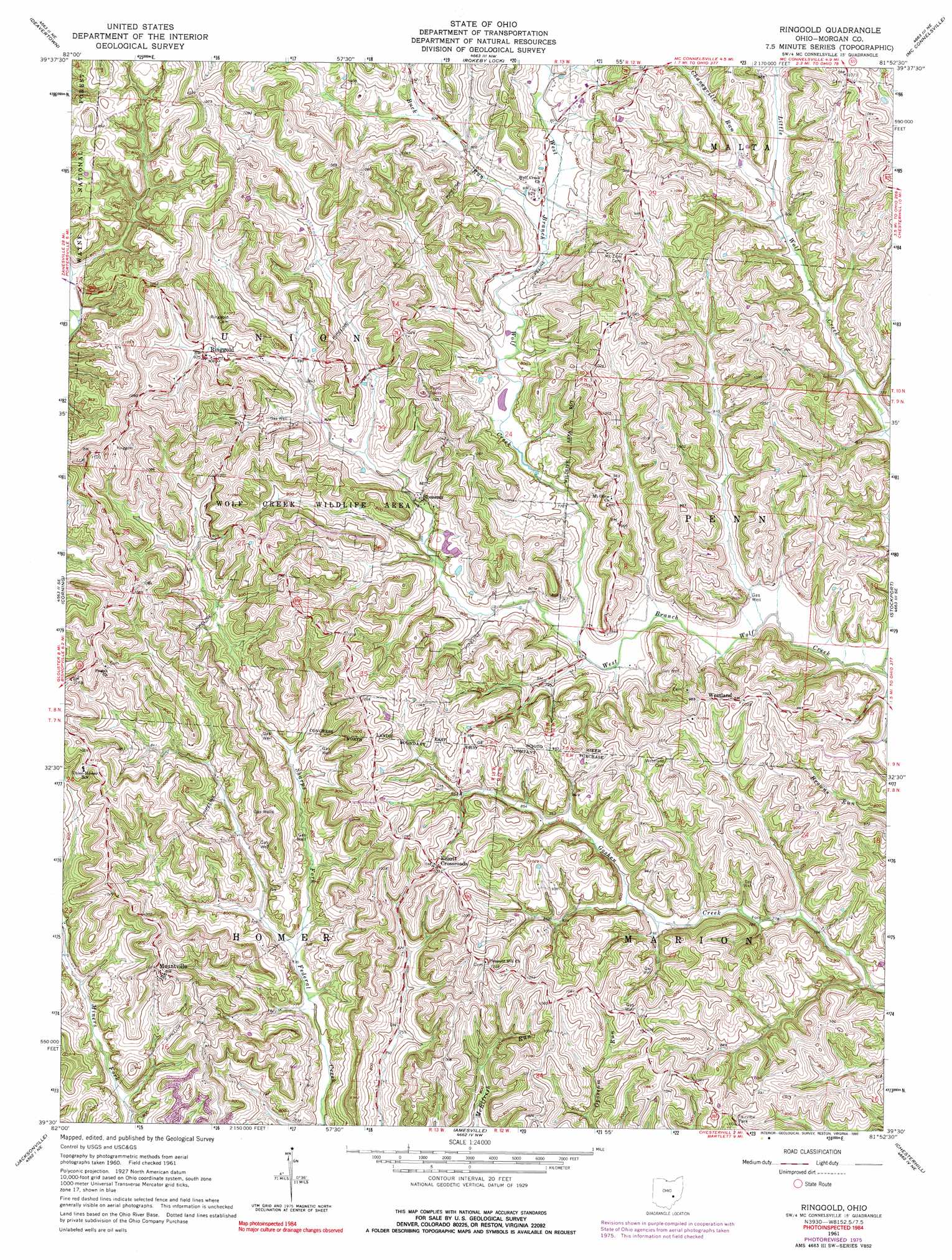
Ringgold Topo Map Ohio
To zoom in, hover over the map of Ringgold
USGS Topo Quad 39081e8 - 1:24,000 scale
| Topo Map Name: | Ringgold |
| USGS Topo Quad ID: | 39081e8 |
| Print Size: | ca. 21 1/4" wide x 27" high |
| Southeast Coordinates: | 39.5° N latitude / 81.875° W longitude |
| Map Center Coordinates: | 39.5625° N latitude / 81.9375° W longitude |
| U.S. State: | OH |
| Filename: | o39081e8.jpg |
| Download Map JPG Image: | Ringgold topo map 1:24,000 scale |
| Map Type: | Topographic |
| Topo Series: | 7.5´ |
| Map Scale: | 1:24,000 |
| Source of Map Images: | United States Geological Survey (USGS) |
| Alternate Map Versions: |
Ringgold OH 1961, updated 1963 Download PDF Buy paper map Ringgold OH 1961, updated 1973 Download PDF Buy paper map Ringgold OH 1961, updated 1977 Download PDF Buy paper map Ringgold OH 1961, updated 1990 Download PDF Buy paper map Ringgold OH 1994, updated 1998 Download PDF Buy paper map Ringgold OH 2011 Download PDF Buy paper map Ringgold OH 2013 Download PDF Buy paper map Ringgold OH 2016 Download PDF Buy paper map |
| FStopo: | US Forest Service topo Ringgold is available: Download FStopo PDF Download FStopo TIF |
1:24,000 Topo Quads surrounding Ringgold
Fultonham |
Crooksville |
Philo |
Ruraldale |
Cumberland |
New Lexington |
Deavertown |
Rokeby Lock |
Mcconnelsville |
Reinersville |
New Straitsville |
Corning |
Ringgold |
Stockport |
Beverly |
Nelsonville |
Jacksonville |
Amesville |
Chesterhill |
Watertown |
The Plains |
Athens |
Stewart |
Cutler |
Little Hocking |
> Back to 39081e1 at 1:100,000 scale
> Back to 39080a1 at 1:250,000 scale
> Back to U.S. Topo Maps home
Ringgold topo map: Gazetteer
Ringgold: Dams
Comstock Pond Dam elevation 254m 833′Wildlife Pond Dam 9417-001 elevation 255m 836′
Ringgold: Parks
Fairview Park elevation 305m 1000′Wolf Creek Wildlife Area elevation 308m 1010′
Ringgold: Populated Places
Chaneyville (historical) elevation 299m 980′Elliott Crossroads elevation 314m 1030′
Mountville elevation 306m 1003′
Ringgold elevation 281m 921′
Rosseau elevation 244m 800′
Shilling (historical) elevation 322m 1056′
Westland elevation 310m 1017′
Ringgold: Post Offices
Cheneyville Post Office (historical) elevation 298m 977′Elliott Post Office (historical) elevation 317m 1040′
Mountville Post Office (historical) elevation 306m 1003′
Rosseau Post Office (historical) elevation 243m 797′
Shilling Post Office (historical) elevation 321m 1053′
Westland Post Office (historical) elevation 309m 1013′
Ringgold: Reservoirs
Comstock Pond elevation 254m 833′Wildlife Pond 9417-001 elevation 255m 836′
Ringgold: Streams
Buck Run elevation 241m 790′Chaneyville Run elevation 242m 793′
Little Wolf Creek elevation 225m 738′
Ringgold digital topo map on disk
Buy this Ringgold topo map showing relief, roads, GPS coordinates and other geographical features, as a high-resolution digital map file on DVD:
 map DVD")