Byesville Topo Map Ohio
To zoom in, hover over the map of Byesville
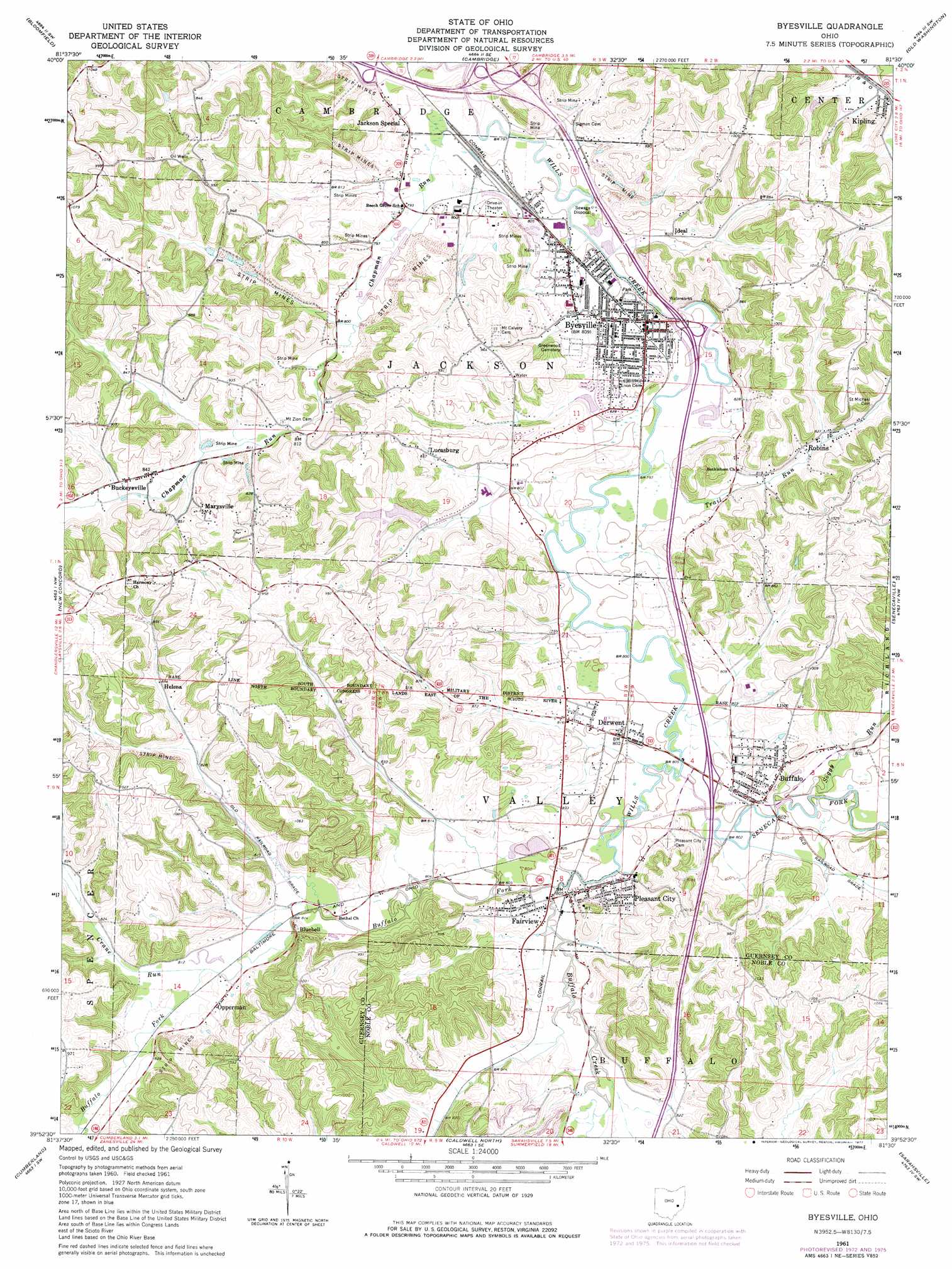
USGS Topo Quad 39081h5 - 1:24,000 scale
| Topo Map Name: | Byesville |
| USGS Topo Quad ID: | 39081h5 |
| Print Size: | ca. 21 1/4" wide x 27" high |
| Southeast Coordinates: | 39.875° N latitude / 81.5° W longitude |
| Map Center Coordinates: | 39.9375° N latitude / 81.5625° W longitude |
| U.S. State: | OH |
| Filename: | o39081h5.jpg |
| Download Map JPG Image: | Byesville topo map 1:24,000 scale |
| Map Type: | Topographic |
| Topo Series: | 7.5´ |
| Map Scale: | 1:24,000 |
| Source of Map Images: | United States Geological Survey (USGS) |
| Alternate Map Versions: |
Byesville OH 1961, updated 1963 Download PDF Buy paper map Byesville OH 1961, updated 1973 Download PDF Buy paper map Byesville OH 1961, updated 1974 Download PDF Buy paper map Byesville OH 1961, updated 1977 Download PDF Buy paper map Byesville OH 1994, updated 1998 Download PDF Buy paper map Byesville OH 2010 Download PDF Buy paper map Byesville OH 2013 Download PDF Buy paper map Byesville OH 2016 Download PDF Buy paper map |
1:24,000 Topo Quads surrounding Byesville
Wills Creek |
Plainfield |
Kimbolton |
Birmingham |
Freeport |
Otsego |
Bloomfield |
Cambridge |
Old Washington |
Antrim |
Norwich |
New Concord |
Byesville |
Senecaville |
Quaker City |
Ruraldale |
Cumberland |
Caldwell North |
Sarahsville |
Summerfield |
Mcconnelsville |
Reinersville |
Caldwell South |
Macksburg |
Stafford |
> Back to 39081e1 at 1:100,000 scale
> Back to 39080a1 at 1:250,000 scale
> Back to U.S. Topo Maps home
Byesville topo map: Gazetteer
Byesville: Airports
Cambridge Municipal Airport elevation 240m 787′Byesville: Crossings
Interchange 178 elevation 246m 807′Interchange 37 elevation 244m 800′
Interchange 41 elevation 244m 800′
Byesville: Populated Places
Bluebell elevation 257m 843′Buckeyeville elevation 257m 843′
Buffalo elevation 262m 859′
Byesville elevation 249m 816′
Derwent elevation 245m 803′
Fairview elevation 249m 816′
Helena elevation 260m 853′
Ideal elevation 245m 803′
Jackson Special elevation 243m 797′
Kipling elevation 250m 820′
Lucasburg elevation 259m 849′
Marysville elevation 280m 918′
Oakwood elevation 252m 826′
Opperman elevation 254m 833′
Pleasant City elevation 251m 823′
Robins elevation 251m 823′
Spring Valley elevation 243m 797′
Byesville: Post Offices
Blue Bell Post Office (historical) elevation 244m 800′Buffalo Post Office elevation 257m 843′
Byesville Post Office elevation 249m 816′
Derwent Post Office elevation 246m 807′
Fairview Post Office elevation 281m 921′
Kipling Post Office elevation 251m 823′
Lucasburg Post Office (historical) elevation 257m 843′
Opperman Post Office (historical) elevation 254m 833′
Pleasant City Post Office elevation 247m 810′
Quaker City Post Office elevation 293m 961′
Robins Post Office (historical) elevation 254m 833′
Byesville: Reservoirs
Indian Lakes Recreation Area Lower Lake elevation 251m 823′Indian Lakes Recreation Area Upper Lake elevation 258m 846′
Byesville: Streams
Buffalo Creek elevation 244m 800′Buffalo Fork elevation 244m 800′
Chapman Run elevation 241m 790′
Crane Run elevation 248m 813′
Seneca Fork Wills Creek elevation 243m 797′
Soggy Run elevation 244m 800′
Trail Run elevation 239m 784′
Yoker Creek elevation 247m 810′
Byesville digital topo map on disk
Buy this Byesville topo map showing relief, roads, GPS coordinates and other geographical features, as a high-resolution digital map file on DVD:
 map DVD")