Pomeroy Topo Map Ohio
To zoom in, hover over the map of Pomeroy
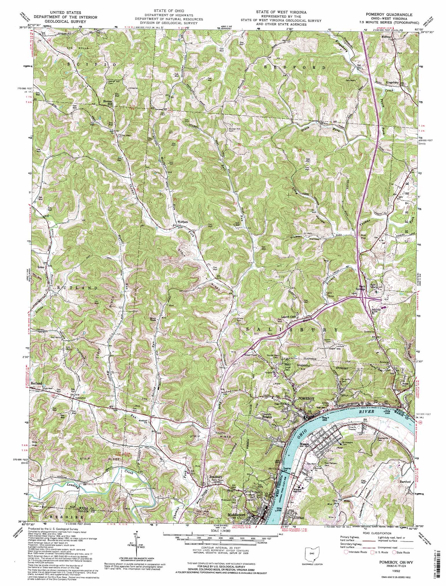
USGS Topo Quad 39082a1 - 1:24,000 scale
| Topo Map Name: | Pomeroy |
| USGS Topo Quad ID: | 39082a1 |
| Print Size: | ca. 21 1/4" wide x 27" high |
| Southeast Coordinates: | 39° N latitude / 82° W longitude |
| Map Center Coordinates: | 39.0625° N latitude / 82.0625° W longitude |
| U.S. States: | OH, WV |
| Filename: | o39082a1.jpg |
| Download Map JPG Image: | Pomeroy topo map 1:24,000 scale |
| Map Type: | Topographic |
| Topo Series: | 7.5´ |
| Map Scale: | 1:24,000 |
| Source of Map Images: | United States Geological Survey (USGS) |
| Alternate Map Versions: |
Pomeroy OH 1960, updated 1961 Download PDF Buy paper map Pomeroy OH 1960, updated 1968 Download PDF Buy paper map Pomeroy OH 1960, updated 1972 Download PDF Buy paper map Pomeroy OH 1960, updated 1976 Download PDF Buy paper map Pomeroy OH 1992, updated 1995 Download PDF Buy paper map Pomeroy OH 2011 Download PDF Buy paper map Pomeroy OH 2013 Download PDF Buy paper map Pomeroy OH 2016 Download PDF Buy paper map |
1:24,000 Topo Quads surrounding Pomeroy
Mineral |
The Plains |
Athens |
Stewart |
Cutler |
Vales Mills |
Albany |
Shade |
Alfred |
Coolville |
Wilkesville |
Rutland |
Pomeroy |
Chester |
Portland |
Vinton |
Addison |
Cheshire |
New Haven |
Ravenswood |
Rodney |
Gallipolis |
Beech Hill |
Mount Alto |
Cottageville |
> Back to 39082a1 at 1:100,000 scale
> Back to 39082a1 at 1:250,000 scale
> Back to U.S. Topo Maps home
Pomeroy topo map: Gazetteer
Pomeroy: Airports
Pomeroy-Mason Seaplane Base elevation 178m 583′Pomeroy: Bends
Pomeroy Bend elevation 165m 541′Pomeroy: Bridges
Pomeroy-Mason Toll Bridge elevation 164m 538′Pomeroy: Parks
Pomeroy Historic District elevation 173m 567′Pomeroy: Populated Places
Bradbury elevation 173m 567′Browntown elevation 177m 580′
Bunker Hill (historical) elevation 288m 944′
Clifton elevation 175m 574′
Horner Hill elevation 231m 757′
Kerrs Run elevation 176m 577′
Kingsbury elevation 200m 656′
Lima elevation 182m 597′
Lincoln Heights elevation 251m 823′
Mason elevation 178m 583′
Middleport elevation 173m 567′
Midway elevation 237m 777′
Pomeroy elevation 174m 570′
Rock Springs elevation 194m 636′
Thomas Village elevation 177m 580′
Wolfpen elevation 192m 629′
Pomeroy: Post Offices
Bradbury Post Office (historical) elevation 174m 570′Kingsbury Office (historical) elevation 197m 646′
Middleport Post Office elevation 173m 567′
Pomeroy Post Office elevation 175m 574′
Rock Springs Post Office (historical) elevation 199m 652′
Wolfpen Post Office (historical) elevation 193m 633′
Pomeroy: Springs
Earl Ewing Spring elevation 184m 603′Oxan Love Spring elevation 204m 669′
Pomeroy: Streams
Bailey Run elevation 170m 557′Ball Run elevation 181m 593′
East Branch Thomas Fork elevation 181m 593′
Forest Run elevation 165m 541′
Hysell Run elevation 170m 557′
Monkey Run elevation 173m 567′
Naylors Run elevation 165m 541′
Peach Fork elevation 198m 649′
Wolfpen Run elevation 192m 629′
Pomeroy: Summits
Rose Hill elevation 240m 787′Pomeroy: Valleys
Bone Hollow elevation 165m 541′Carter Oak Hollow elevation 176m 577′
Dark Hollow elevation 173m 567′
Grueser Hollow elevation 191m 626′
Long Hollow elevation 190m 623′
Loudermilk Hollow elevation 187m 613′
Pomeroy digital topo map on disk
Buy this Pomeroy topo map showing relief, roads, GPS coordinates and other geographical features, as a high-resolution digital map file on DVD:
 map DVD")