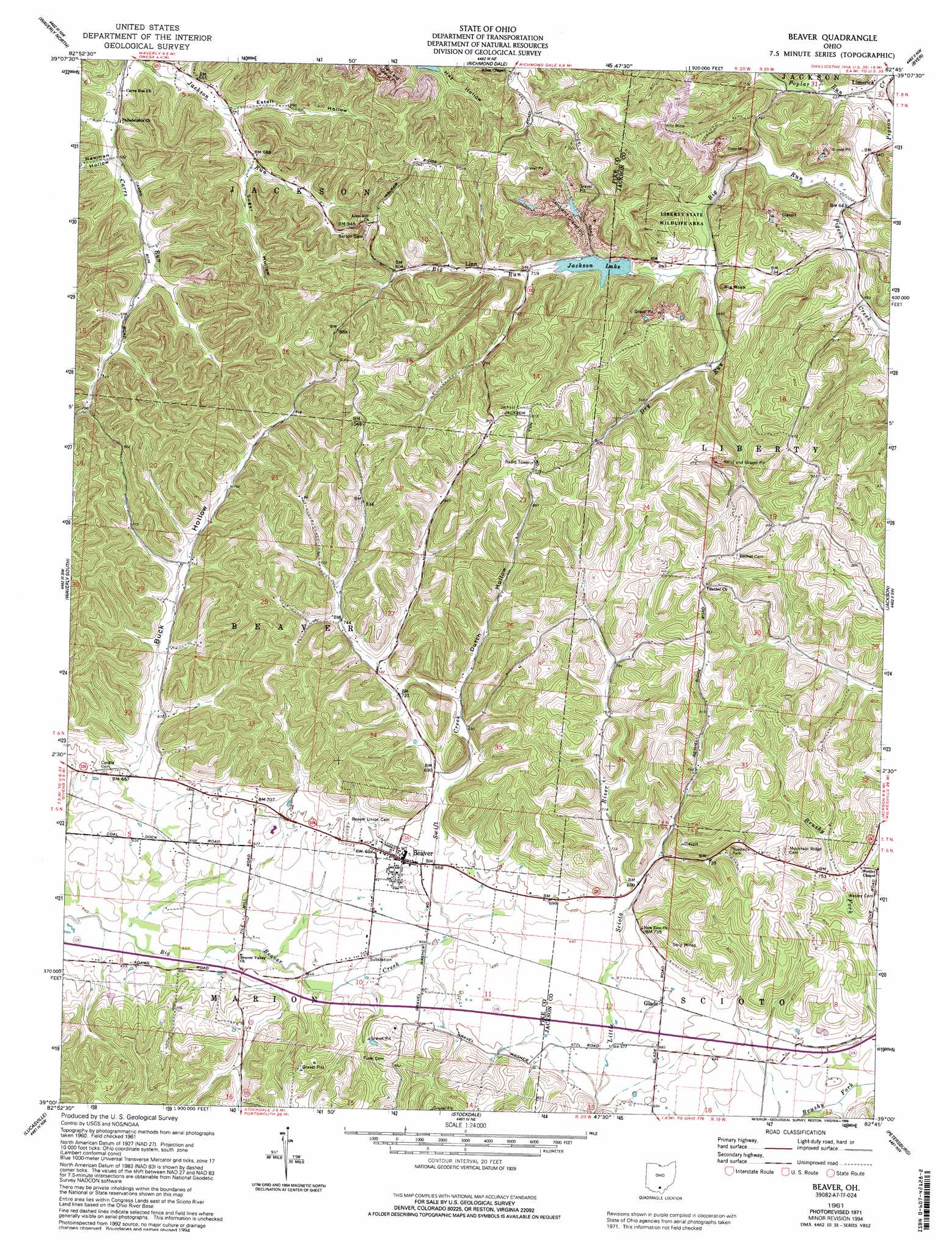
Beaver Topo Map Ohio
To zoom in, hover over the map of Beaver
USGS Topo Quad 39082a7 - 1:24,000 scale
| Topo Map Name: | Beaver |
| USGS Topo Quad ID: | 39082a7 |
| Print Size: | ca. 21 1/4" wide x 27" high |
| Southeast Coordinates: | 39° N latitude / 82.75° W longitude |
| Map Center Coordinates: | 39.0625° N latitude / 82.8125° W longitude |
| U.S. State: | OH |
| Filename: | o39082a7.jpg |
| Download Map JPG Image: | Beaver topo map 1:24,000 scale |
| Map Type: | Topographic |
| Topo Series: | 7.5´ |
| Map Scale: | 1:24,000 |
| Source of Map Images: | United States Geological Survey (USGS) |
| Alternate Map Versions: |
Beaver OH 1961, updated 1963 Download PDF Buy paper map Beaver OH 1961, updated 1973 Download PDF Buy paper map Beaver OH 1961, updated 1985 Download PDF Buy paper map Beaver OH 1961, updated 1995 Download PDF Buy paper map Beaver OH 1961, updated 1996 Download PDF Buy paper map Beaver OH 2010 Download PDF Buy paper map Beaver OH 2013 Download PDF Buy paper map Beaver OH 2016 Download PDF Buy paper map |
1:24,000 Topo Quads surrounding Beaver
Chillicothe West |
Chillicothe East |
Londonderry |
Ratcliffburg |
Allensville |
Summithill |
Waverly North |
Richmond Dale |
Byer |
Hamden |
Piketon |
Waverly South |
Beaver |
Jackson |
Wellston |
Wakefield |
Lucasville |
Stockdale |
Petersburg |
Oak Hill |
West Portsmouth |
New Boston |
Minford |
South Webster |
Gallia |
> Back to 39082a1 at 1:100,000 scale
> Back to 39082a1 at 1:250,000 scale
> Back to U.S. Topo Maps home
Beaver topo map: Gazetteer
Beaver: Airports
Glade Stolport elevation 207m 679′Beaver: Dams
Big Rock Lake Dam elevation 245m 803′Beaver: Lakes
Jackson Lake elevation 214m 702′Beaver: Parks
Liberty Wildlife Area elevation 223m 731′Beaver: Populated Places
Beaver elevation 209m 685′Big Rock elevation 207m 679′
Cars Run (historical) elevation 213m 698′
Eastburn (historical) elevation 197m 646′
Glade elevation 210m 688′
Linn elevation 227m 744′
Beaver: Post Offices
Beaver Post Office elevation 209m 685′Cars Run Post Office (historical) elevation 219m 718′
Eastburn Post Office (historical) elevation 197m 646′
Glade Post Office (historical) elevation 210m 688′
Linn Post Office (historical) elevation 235m 770′
Beaver: Reservoirs
Big Rock Lake elevation 245m 803′Beaver: Streams
Bee Lick elevation 189m 620′Big Run elevation 195m 639′
Dry Run elevation 203m 666′
Poplar Run elevation 191m 626′
Swift Creek elevation 200m 656′
Beaver: Summits
Big Rock elevation 259m 849′Beaver: Valleys
Buck Hollow elevation 199m 652′Dutch Hollow elevation 219m 718′
Estell Hollow elevation 196m 643′
Newman Hollow elevation 190m 623′
Sugar Hollow elevation 203m 666′
Beaver digital topo map on disk
Buy this Beaver topo map showing relief, roads, GPS coordinates and other geographical features, as a high-resolution digital map file on DVD:
 map DVD")