Jacksonville Topo Map Ohio
To zoom in, hover over the map of Jacksonville
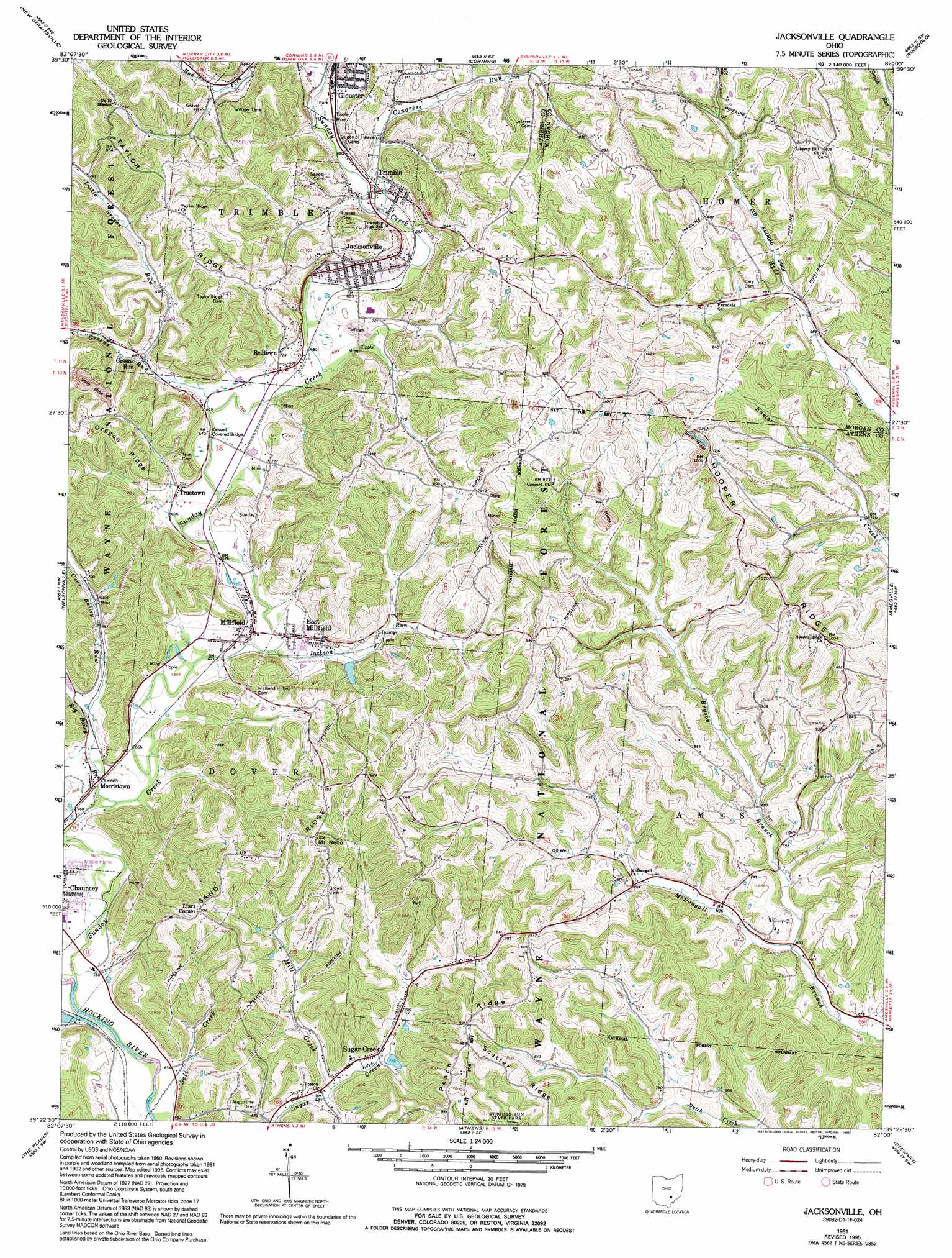
USGS Topo Quad 39082d1 - 1:24,000 scale
| Topo Map Name: | Jacksonville |
| USGS Topo Quad ID: | 39082d1 |
| Print Size: | ca. 21 1/4" wide x 27" high |
| Southeast Coordinates: | 39.375° N latitude / 82° W longitude |
| Map Center Coordinates: | 39.4375° N latitude / 82.0625° W longitude |
| U.S. State: | OH |
| Filename: | o39082d1.jpg |
| Download Map JPG Image: | Jacksonville topo map 1:24,000 scale |
| Map Type: | Topographic |
| Topo Series: | 7.5´ |
| Map Scale: | 1:24,000 |
| Source of Map Images: | United States Geological Survey (USGS) |
| Alternate Map Versions: |
Jacksonville OH 1961, updated 1962 Download PDF Buy paper map Jacksonville OH 1961, updated 1973 Download PDF Buy paper map Jacksonville OH 1961, updated 1977 Download PDF Buy paper map Jacksonville OH 1961, updated 1990 Download PDF Buy paper map Jacksonville OH 1961, updated 1995 Download PDF Buy paper map Jacksonville OH 2002, updated 2006 Download PDF Buy paper map Jacksonville OH 2011 Download PDF Buy paper map Jacksonville OH 2013 Download PDF Buy paper map Jacksonville OH 2016 Download PDF Buy paper map |
| FStopo: | US Forest Service topo Jacksonville is available: Download FStopo PDF Download FStopo TIF |
1:24,000 Topo Quads surrounding Jacksonville
Junction City |
New Lexington |
Deavertown |
Rokeby Lock |
Mcconnelsville |
Gore |
New Straitsville |
Corning |
Ringgold |
Stockport |
Union Furnace |
Nelsonville |
Jacksonville |
Amesville |
Chesterhill |
Mineral |
The Plains |
Athens |
Stewart |
Cutler |
Vales Mills |
Albany |
Shade |
Alfred |
Coolville |
> Back to 39082a1 at 1:100,000 scale
> Back to 39082a1 at 1:250,000 scale
> Back to U.S. Topo Maps home
Jacksonville topo map: Gazetteer
Jacksonville: Bridges
Kidwell Bridge elevation 201m 659′Kidwell Covered Bridge elevation 249m 816′
Jacksonville: Populated Places
Derthick elevation 230m 754′East Millfield elevation 205m 672′
Greens Run elevation 204m 669′
Jacksonville elevation 209m 685′
Lewis (historical) elevation 257m 843′
Liars Corner elevation 301m 987′
Linscott (historical) elevation 308m 1010′
Millfield elevation 200m 656′
Morristown elevation 206m 675′
Olbers elevation 286m 938′
Poston elevation 210m 688′
Redtown elevation 227m 744′
Sugar Creek elevation 208m 682′
Trimble elevation 202m 662′
Truetown elevation 213m 698′
Jacksonville: Post Offices
Jacksonville Post Office elevation 209m 685′Lewis Post Office (historical) elevation 257m 843′
Millfield Post Office elevation 201m 659′
Millfield Post Office (historical) elevation 201m 659′
Olbers Post Office (historical) elevation 274m 898′
Poston Post Office (historical) elevation 221m 725′
Trimble Post Office elevation 202m 662′
Jacksonville: Ridges
Hooper Ridge elevation 314m 1030′Sand Ridge elevation 290m 951′
Scatter Ridge elevation 294m 964′
Taylor Ridge elevation 294m 964′
Jacksonville: Streams
Big Bailey Run elevation 198m 649′Bryson Branch elevation 201m 659′
Carr Bailey Run elevation 200m 656′
Congress Run elevation 201m 659′
Greens Run elevation 200m 656′
Jackson Run elevation 201m 659′
Little Greens Run elevation 206m 675′
Mill Creek elevation 207m 679′
Salt Creek elevation 195m 639′
Sunday Creek elevation 195m 639′
Jacksonville: Summits
Mount Nebo elevation 310m 1017′Jacksonville digital topo map on disk
Buy this Jacksonville topo map showing relief, roads, GPS coordinates and other geographical features, as a high-resolution digital map file on DVD:
 map DVD")