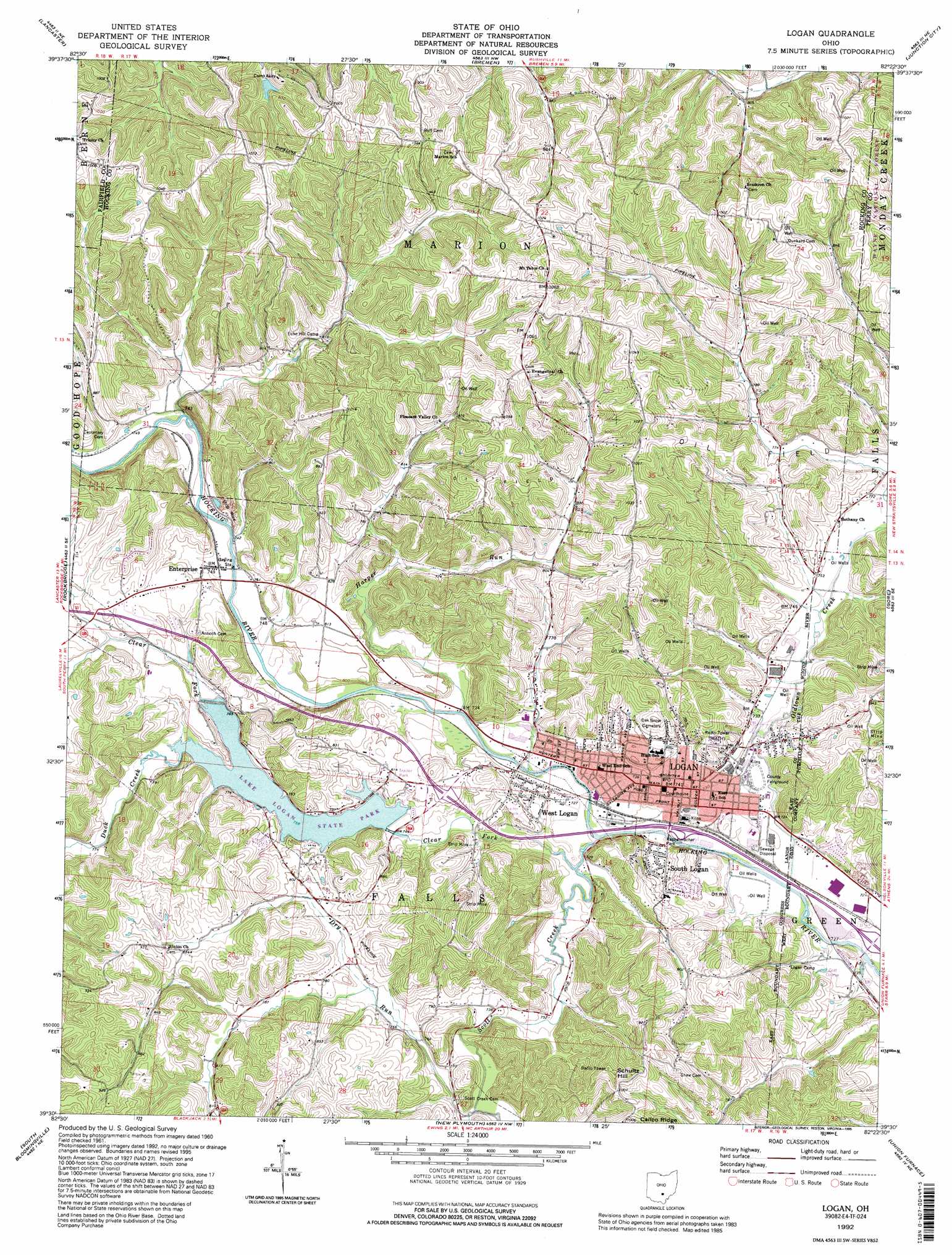
Logan Topo Map Ohio
To zoom in, hover over the map of Logan
USGS Topo Quad 39082e4 - 1:24,000 scale
| Topo Map Name: | Logan |
| USGS Topo Quad ID: | 39082e4 |
| Print Size: | ca. 21 1/4" wide x 27" high |
| Southeast Coordinates: | 39.5° N latitude / 82.375° W longitude |
| Map Center Coordinates: | 39.5625° N latitude / 82.4375° W longitude |
| U.S. State: | OH |
| Filename: | o39082e4.jpg |
| Download Map JPG Image: | Logan topo map 1:24,000 scale |
| Map Type: | Topographic |
| Topo Series: | 7.5´ |
| Map Scale: | 1:24,000 |
| Source of Map Images: | United States Geological Survey (USGS) |
| Alternate Map Versions: |
Logan OH 1961, updated 1963 Download PDF Buy paper map Logan OH 1961, updated 1969 Download PDF Buy paper map Logan OH 1961, updated 1977 Download PDF Buy paper map Logan OH 1961, updated 1985 Download PDF Buy paper map Logan OH 1992, updated 1995 Download PDF Buy paper map Logan OH 2011 Download PDF Buy paper map Logan OH 2013 Download PDF Buy paper map Logan OH 2016 Download PDF Buy paper map |
1:24,000 Topo Quads surrounding Logan
Carroll |
Baltimore |
Rushville |
Somerset |
Fultonham |
Amanda |
Lancaster |
Bremen |
Junction City |
New Lexington |
Clearport |
Rockbridge |
Logan |
Gore |
New Straitsville |
Laurelville |
South Bloomingville |
New Plymouth |
Union Furnace |
Nelsonville |
Ratcliffburg |
Allensville |
Zaleski |
Mineral |
The Plains |
> Back to 39082e1 at 1:100,000 scale
> Back to 39082a1 at 1:250,000 scale
> Back to U.S. Topo Maps home
Logan topo map: Gazetteer
Logan: Airports
Lazy-W Airport elevation 229m 751′Logan: Dams
Lake Logan Dam elevation 226m 741′Middletown Park District Lake Dam elevation 251m 823′
Logan: Parks
Hocking County Fairgrounds elevation 217m 711′Kachelmacher Park elevation 217m 711′
Lake Logan State Park elevation 226m 741′
Logan: Populated Places
Enterprise elevation 237m 777′Logan elevation 226m 741′
South Logan elevation 231m 757′
West Logan elevation 230m 754′
Logan: Post Offices
Enterprise Post Office (historical) elevation 233m 764′Logan Post Office elevation 227m 744′
Logan: Reservoirs
Hocking County Lake elevation 230m 754′Lake Logan elevation 226m 741′
Middletown Park District Dam elevation 251m 823′
Logan: Streams
Clear Fork elevation 217m 711′Dry Run elevation 235m 770′
Duck Creek elevation 231m 757′
Harper Run elevation 220m 721′
Helber Run elevation 225m 738′
Oldtown Creek elevation 219m 718′
Scott Creek elevation 229m 751′
Scott Creek elevation 219m 718′
Logan: Summits
Schultz Hill elevation 337m 1105′Logan digital topo map on disk
Buy this Logan topo map showing relief, roads, GPS coordinates and other geographical features, as a high-resolution digital map file on DVD:
 map DVD")