Thornville Topo Map Ohio
To zoom in, hover over the map of Thornville
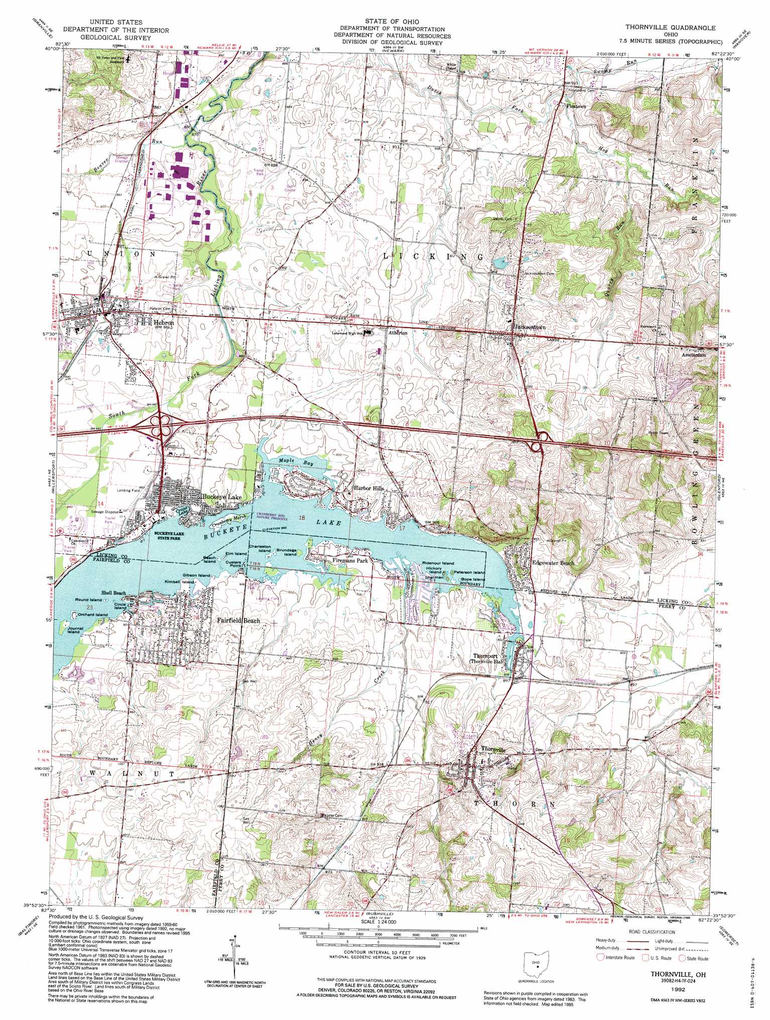
USGS Topo Quad 39082h4 - 1:24,000 scale
| Topo Map Name: | Thornville |
| USGS Topo Quad ID: | 39082h4 |
| Print Size: | ca. 21 1/4" wide x 27" high |
| Southeast Coordinates: | 39.875° N latitude / 82.375° W longitude |
| Map Center Coordinates: | 39.9375° N latitude / 82.4375° W longitude |
| U.S. State: | OH |
| Filename: | o39082h4.jpg |
| Download Map JPG Image: | Thornville topo map 1:24,000 scale |
| Map Type: | Topographic |
| Topo Series: | 7.5´ |
| Map Scale: | 1:24,000 |
| Source of Map Images: | United States Geological Survey (USGS) |
| Alternate Map Versions: |
Thornville OH 1961, updated 1962 Download PDF Buy paper map Thornville OH 1961, updated 1962 Download PDF Buy paper map Thornville OH 1961, updated 1973 Download PDF Buy paper map Thornville OH 1961, updated 1977 Download PDF Buy paper map Thornville OH 1961, updated 1985 Download PDF Buy paper map Thornville OH 1992, updated 1995 Download PDF Buy paper map Thornville OH 2010 Download PDF Buy paper map Thornville OH 2013 Download PDF Buy paper map Thornville OH 2016 Download PDF Buy paper map |
1:24,000 Topo Quads surrounding Thornville
Johnstown |
Fredonia |
Utica |
Hickman |
Perryton |
Jersey |
Granville |
Newark |
Hanover |
Toboso |
Pataskala |
Millersport |
Thornville |
Glenford |
Gratiot |
Carroll |
Baltimore |
Rushville |
Somerset |
Fultonham |
Amanda |
Lancaster |
Bremen |
Junction City |
New Lexington |
> Back to 39082e1 at 1:100,000 scale
> Back to 39082a1 at 1:250,000 scale
> Back to U.S. Topo Maps home
Thornville topo map: Gazetteer
Thornville: Airports
Clum Airport elevation 338m 1108′Roberts Field elevation 274m 898′
Thornville: Bays
Maple Bay elevation 273m 895′Thornville: Capes
Custers Point elevation 273m 895′Thornville: Crossings
Interchange 129 elevation 271m 889′Interchange 132 elevation 320m 1049′
Thornville: Dams
Binns Lake Dam elevation 323m 1059′Buckeye Lake Dam elevation 268m 879′
Dawes Arboretum Pond Dam elevation 289m 948′
Shelton Lake Dam elevation 313m 1026′
Thornville: Islands
Beach Island elevation 274m 898′Bope Island elevation 272m 892′
Brundage Island elevation 273m 895′
Charleston Island elevation 273m 895′
Circle Island elevation 274m 898′
Crane Island elevation 274m 898′
Elm Island elevation 274m 898′
Gibson Island elevation 274m 898′
Hickory Island elevation 273m 895′
Journal Island elevation 272m 892′
Kimball Island elevation 273m 895′
Orchard Island elevation 273m 895′
Peterson Island elevation 272m 892′
Ridenour Island elevation 271m 889′
Round Island elevation 274m 898′
Sherman Island elevation 272m 892′
Watkins Island elevation 271m 889′
Thornville: Parks
Buckeye State Lake Park elevation 274m 898′Cranberry Bog State Nature Preserve elevation 273m 895′
Thornville: Populated Places
Amsterdam elevation 359m 1177′Atherton elevation 288m 944′
Buckeye Lake elevation 274m 898′
Edgewater Beach elevation 292m 958′
Fairfield Beach elevation 283m 928′
Firemans Park elevation 274m 898′
Fleatown elevation 274m 898′
Harbor Hills elevation 283m 928′
Hebron elevation 271m 889′
Jacksontown elevation 304m 997′
Moscow (historical) elevation 272m 892′
Shell Beach elevation 274m 898′
Thornport elevation 274m 898′
Thornville elevation 314m 1030′
Thornville: Post Offices
Buckeye Lake Post Office (historical) elevation 274m 898′Harbor Hills Post Office (historical) elevation 283m 928′
Hebron Post Office elevation 270m 885′
Jacksontown Post Office elevation 306m 1003′
Thornport Post Office (historical) elevation 274m 898′
Thornville Post Office elevation 314m 1030′
Thornville: Ranges
Harbor Hills elevation 283m 928′Thornville: Reservoirs
Binns Lake elevation 323m 1059′Buckeye Lake elevation 268m 879′
Crane Lake elevation 273m 895′
Dawes Arboretum Pond elevation 289m 948′
Shelton Lake elevation 313m 1026′
Thornville: Streams
Beaver Run elevation 263m 862′Hog Run elevation 271m 889′
Honey Creek elevation 273m 895′
Quarry Run elevation 278m 912′
Swamp Run elevation 271m 889′
Thornville: Summits
Observatory Hill elevation 274m 898′Thornville: Swamps
Cranberry Marsh elevation 273m 895′Thornville digital topo map on disk
Buy this Thornville topo map showing relief, roads, GPS coordinates and other geographical features, as a high-resolution digital map file on DVD:
 map DVD")