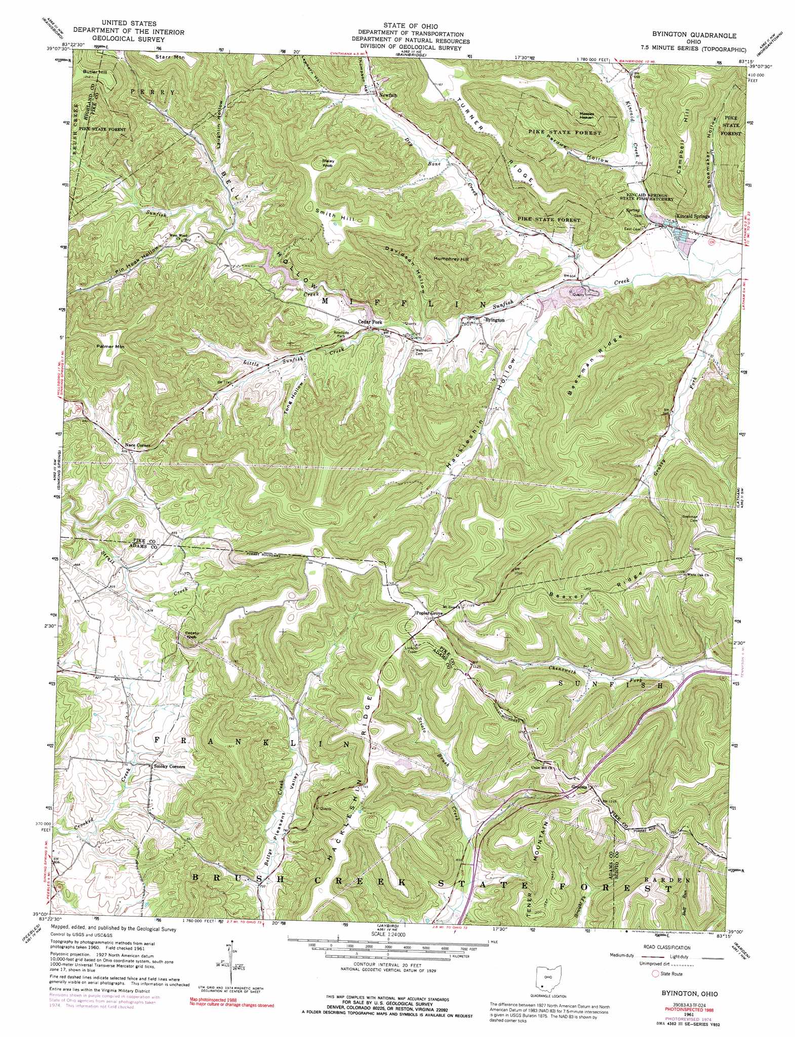
Byington Topo Map Ohio
To zoom in, hover over the map of Byington
USGS Topo Quad 39083a3 - 1:24,000 scale
| Topo Map Name: | Byington |
| USGS Topo Quad ID: | 39083a3 |
| Print Size: | ca. 21 1/4" wide x 27" high |
| Southeast Coordinates: | 39° N latitude / 83.25° W longitude |
| Map Center Coordinates: | 39.0625° N latitude / 83.3125° W longitude |
| U.S. State: | OH |
| Filename: | o39083a3.jpg |
| Download Map JPG Image: | Byington topo map 1:24,000 scale |
| Map Type: | Topographic |
| Topo Series: | 7.5´ |
| Map Scale: | 1:24,000 |
| Source of Map Images: | United States Geological Survey (USGS) |
| Alternate Map Versions: |
Byington OH 1961, updated 1963 Download PDF Buy paper map Byington OH 1961, updated 1974 Download PDF Buy paper map Byington OH 1961, updated 1976 Download PDF Buy paper map Byington OH 1961, updated 1992 Download PDF Buy paper map Byington OH 2010 Download PDF Buy paper map Byington OH 2013 Download PDF Buy paper map Byington OH 2016 Download PDF Buy paper map |
1:24,000 Topo Quads surrounding Byington
Leesburg |
Greenfield |
South Salem |
Bourneville |
Chillicothe West |
Hillsboro |
Rainsboro |
Bainbridge |
Morgantown |
Summithill |
Belfast |
Sinking Spring |
Byington |
Latham |
Piketon |
Seaman |
Peebles |
Jaybird |
Rarden |
Wakefield |
West Union |
Lynx |
Blue Creek |
Otway |
West Portsmouth |
> Back to 39083a1 at 1:100,000 scale
> Back to 39082a1 at 1:250,000 scale
> Back to U.S. Topo Maps home
Byington topo map: Gazetteer
Byington: Dams
Cave Lake Dam elevation 260m 853′Longs Retreat Dam elevation 237m 777′
Byington: Mines
Ford Quarry elevation 207m 679′Byington: Populated Places
Byington elevation 203m 666′Cedar Fork elevation 210m 688′
Grooms elevation 372m 1220′
Kincaid Springs elevation 193m 633′
Nace Corner elevation 253m 830′
Newfain elevation 248m 813′
Poplar Grove elevation 342m 1122′
Smoky Corners elevation 247m 810′
Byington: Post Offices
Byington Post Office (historical) elevation 204m 669′Newfain Post Office (historical) elevation 235m 770′
Poplargrove Post Office elevation 345m 1131′
Byington: Reservoirs
Cave Lake elevation 260m 853′Longs Retreat Lake elevation 237m 777′
Byington: Ridges
Beekman Ridge elevation 331m 1085′Hackleshin Ridge elevation 348m 1141′
Turner Ridge elevation 359m 1177′
Byington: Streams
Dry Bone Creek elevation 194m 636′Kincaid Creek elevation 190m 623′
Little Sunfish Creek elevation 209m 685′
Byington: Summits
Butler Hill elevation 379m 1243′Campbell Hill elevation 347m 1138′
Humphrey Hill elevation 348m 1141′
Massies Heaven elevation 373m 1223′
Palmer Mountain elevation 378m 1240′
Potato Knob elevation 349m 1145′
Smith Hill elevation 366m 1200′
Staley Knob elevation 376m 1233′
Byington: Valleys
Bell Hollow elevation 207m 679′Davidson Hollow elevation 211m 692′
Fields Hollow elevation 201m 659′
Hackleshin Hollow elevation 202m 662′
Hopek Hollow elevation 221m 725′
Laughlin Hollow elevation 226m 741′
Lawhorn Hollow elevation 236m 774′
Perdue Hollow elevation 198m 649′
Pin Hook Hollow elevation 232m 761′
Shoemaker Hollow elevation 203m 666′
Thompson Hollow elevation 232m 761′
Tong Hollow elevation 219m 718′
Byington digital topo map on disk
Buy this Byington topo map showing relief, roads, GPS coordinates and other geographical features, as a high-resolution digital map file on DVD:
 map DVD")