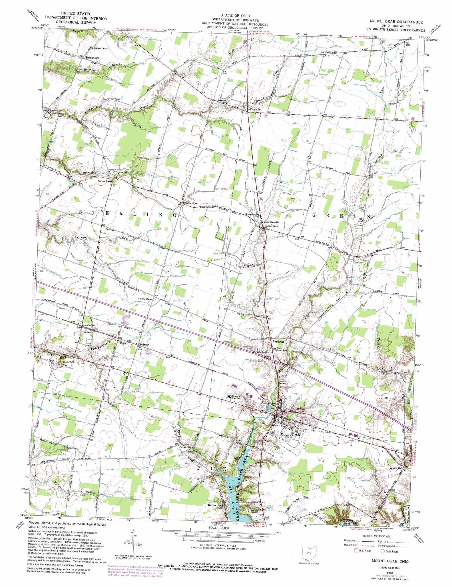
Mount Orab Topo Map Ohio
To zoom in, hover over the map of Mount Orab
USGS Topo Quad 39083a8 - 1:24,000 scale
| Topo Map Name: | Mount Orab |
| USGS Topo Quad ID: | 39083a8 |
| Print Size: | ca. 21 1/4" wide x 27" high |
| Southeast Coordinates: | 39° N latitude / 83.875° W longitude |
| Map Center Coordinates: | 39.0625° N latitude / 83.9375° W longitude |
| U.S. State: | OH |
| Filename: | o39083a8.jpg |
| Download Map JPG Image: | Mount Orab topo map 1:24,000 scale |
| Map Type: | Topographic |
| Topo Series: | 7.5´ |
| Map Scale: | 1:24,000 |
| Source of Map Images: | United States Geological Survey (USGS) |
| Alternate Map Versions: |
Mount Orab OH 1960, updated 1962 Download PDF Buy paper map Mount Orab OH 1960, updated 1970 Download PDF Buy paper map Mount Orab OH 1960, updated 1982 Download PDF Buy paper map Mount Orab OH 1960, updated 1986 Download PDF Buy paper map Mount Orab OH 2010 Download PDF Buy paper map Mount Orab OH 2013 Download PDF Buy paper map Mount Orab OH 2016 Download PDF Buy paper map |
1:24,000 Topo Quads surrounding Mount Orab
South Lebanon |
Pleasant Plain |
Blanchester |
Martinsville |
New Vienna |
Goshen |
Newtonsville |
Fayetteville |
Lynchburg |
New Market |
Batavia |
Williamsburg |
Mount Orab |
Sardinia |
Sugar Tree Ridge |
Laurel |
Bethel |
Hamersville |
Ash Ridge |
Winchester |
Moscow |
Felicity |
Higginsport |
Russellville |
Decatur |
> Back to 39083a1 at 1:100,000 scale
> Back to 39082a1 at 1:250,000 scale
> Back to U.S. Topo Maps home
Mount Orab topo map: Gazetteer
Mount Orab: Airports
Neals Airport elevation 289m 948′Mount Orab: Dams
Mount Orab Upground Reservoir Dam elevation 279m 915′Mount Orab: Lakes
Watson Pond elevation 278m 912′Mount Orab: Parks
Grant Lake Wildlife Area elevation 276m 905′Mount Orab: Populated Places
Andersonville elevation 280m 918′Bardwell elevation 287m 941′
Bloom Rose (historical) elevation 272m 892′
Bodman elevation 286m 938′
Brown County Mobile Home Park elevation 287m 941′
Centerville elevation 289m 948′
Eastwood elevation 283m 928′
Fivemile elevation 290m 951′
Greenbush elevation 288m 944′
J D Smith Mobile Home Park elevation 287m 941′
Moler Mobile Home Park elevation 288m 944′
Mount Orab elevation 287m 941′
Stringtown elevation 282m 925′
Upper Fivemile elevation 293m 961′
White Oak elevation 289m 948′
Mount Orab: Post Offices
Bardwell Post Office (historical) elevation 287m 941′Bloom Rose Post Office (historical) elevation 272m 892′
Eastwood Post Office (historical) elevation 283m 928′
Fivemile Post Office (historical) elevation 290m 951′
Mount Orab Post Office elevation 287m 941′
White Oak Post Office (historical) elevation 289m 948′
Mount Orab: Reservoirs
Mount Orab Reservoir elevation 279m 915′Mount Orab: Streams
East Fork Fivemile Creek elevation 279m 915′East Fork White Oak Creek elevation 271m 889′
Indian Camp Run elevation 276m 905′
North Fork White Oak Creek elevation 271m 889′
Plum Creek elevation 276m 905′
Yellow Run elevation 276m 905′
Mount Orab digital topo map on disk
Buy this Mount Orab topo map showing relief, roads, GPS coordinates and other geographical features, as a high-resolution digital map file on DVD:
 map DVD")