Wilmington Topo Map Ohio
To zoom in, hover over the map of Wilmington
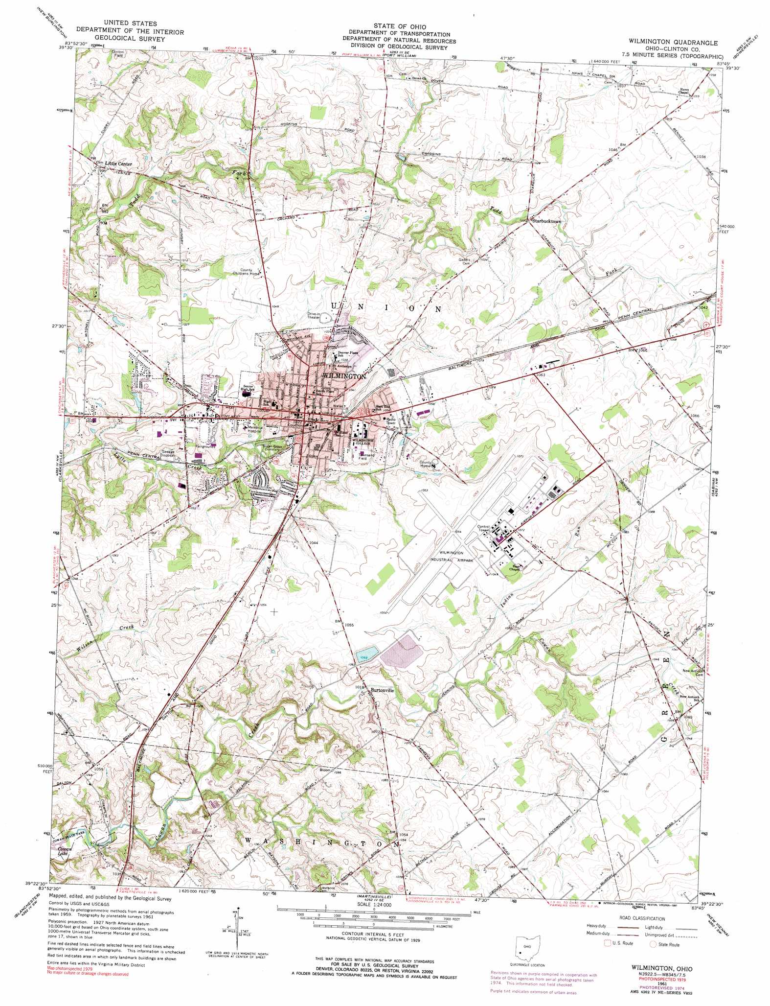
USGS Topo Quad 39083d7 - 1:24,000 scale
| Topo Map Name: | Wilmington |
| USGS Topo Quad ID: | 39083d7 |
| Print Size: | ca. 21 1/4" wide x 27" high |
| Southeast Coordinates: | 39.375° N latitude / 83.75° W longitude |
| Map Center Coordinates: | 39.4375° N latitude / 83.8125° W longitude |
| U.S. State: | OH |
| Filename: | o39083d7.jpg |
| Download Map JPG Image: | Wilmington topo map 1:24,000 scale |
| Map Type: | Topographic |
| Topo Series: | 7.5´ |
| Map Scale: | 1:24,000 |
| Source of Map Images: | United States Geological Survey (USGS) |
| Alternate Map Versions: |
Wilmington OH 1961, updated 1962 Download PDF Buy paper map Wilmington OH 1961, updated 1973 Download PDF Buy paper map Wilmington OH 1961, updated 1976 Download PDF Buy paper map Wilmington OH 1961, updated 1991 Download PDF Buy paper map Wilmington OH 2010 Download PDF Buy paper map Wilmington OH 2013 Download PDF Buy paper map Wilmington OH 2016 Download PDF Buy paper map |
1:24,000 Topo Quads surrounding Wilmington
Bellbrook |
Xenia |
Cedarville |
Jamestown |
Jeffersonville |
Waynesville |
New Burlington |
Port William |
Bowersville |
Milledgeville |
Oregonia |
Clarksville |
Wilmington |
Sabina |
Memphis |
Pleasant Plain |
Blanchester |
Martinsville |
New Vienna |
Leesburg |
Newtonsville |
Fayetteville |
Lynchburg |
New Market |
Hillsboro |
> Back to 39083a1 at 1:100,000 scale
> Back to 39082a1 at 1:250,000 scale
> Back to U.S. Topo Maps home
Wilmington topo map: Gazetteer
Wilmington: Airports
Airborne Airpark elevation 321m 1053′Clinton Memorial Hospital Heliport elevation 311m 1020′
Quail Lakes Heliport elevation 322m 1056′
Wilmington: Dams
Clinton County Tributary Number One Dam elevation 317m 1040′Wilmington Upground Reservoir Dam Number One elevation 321m 1053′
Wilmington Upground Reservoir Number Two Dam elevation 320m 1049′
Wilmington: Parks
David R Williams Memorial Park elevation 320m 1049′Delaney-Tewksbury Baseball Diamond elevation 314m 1030′
Galvin Park elevation 313m 1026′
Townsend Field elevation 315m 1033′
Williams Stadium elevation 314m 1030′
Wilmington Commercial Historic District elevation 312m 1023′
Wilmington: Populated Places
Burtonville elevation 311m 1020′Clinton elevation 318m 1043′
Little Center elevation 303m 994′
McMahan's Mobile Home Park elevation 323m 1059′
Starbucktown elevation 313m 1026′
Town And Country Estates elevation 311m 1020′
White's Mobile Home Park elevation 318m 1043′
Wilmington elevation 310m 1017′
Wilmington: Post Offices
Wilmington Post Office elevation 311m 1020′Wilmington: Reservoirs
Wilmington Reservoir Number One elevation 321m 1053′Wilmington Reservoir Number Two elevation 320m 1049′
Wilmington: Streams
Cowan Creek elevation 294m 964′Dry Run elevation 302m 990′
Indian Run elevation 309m 1013′
Wilmington digital topo map on disk
Buy this Wilmington topo map showing relief, roads, GPS coordinates and other geographical features, as a high-resolution digital map file on DVD:
 map DVD")