Mount Sterling Topo Map Ohio
To zoom in, hover over the map of Mount Sterling
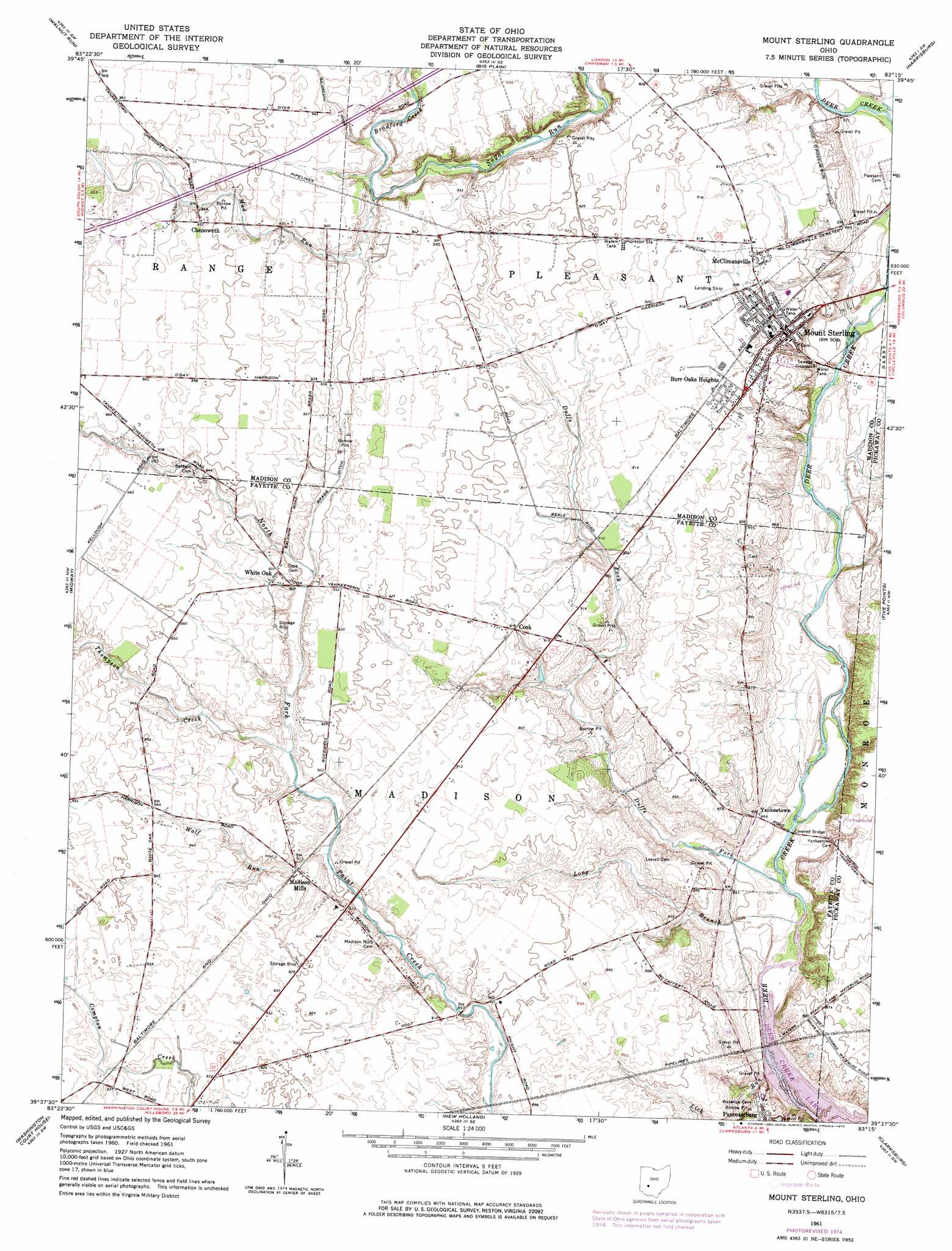
USGS Topo Quad 39083f3 - 1:24,000 scale
| Topo Map Name: | Mount Sterling |
| USGS Topo Quad ID: | 39083f3 |
| Print Size: | ca. 21 1/4" wide x 27" high |
| Southeast Coordinates: | 39.625° N latitude / 83.25° W longitude |
| Map Center Coordinates: | 39.6875° N latitude / 83.3125° W longitude |
| U.S. State: | OH |
| Filename: | o39083f3.jpg |
| Download Map JPG Image: | Mount Sterling topo map 1:24,000 scale |
| Map Type: | Topographic |
| Topo Series: | 7.5´ |
| Map Scale: | 1:24,000 |
| Source of Map Images: | United States Geological Survey (USGS) |
| Alternate Map Versions: |
Mount Sterling OH 1961, updated 1963 Download PDF Buy paper map Mount Sterling OH 1961, updated 1975 Download PDF Buy paper map Mount Sterling OH 2010 Download PDF Buy paper map Mount Sterling OH 2013 Download PDF Buy paper map Mount Sterling OH 2016 Download PDF Buy paper map |
1:24,000 Topo Quads surrounding Mount Sterling
South Vienna |
London |
West Jefferson |
Galloway |
Southwest Columbus |
Florence |
Walnut Run |
Big Plain |
Harrisburg |
Commercial Point |
Jeffersonville |
Midway |
Mount Sterling |
Five Points |
Darbyville |
Milledgeville |
Washington Court House |
New Holland |
Clarksburg |
Williamsport |
Memphis |
New Martinsburg |
Good Hope |
Frankfort |
Andersonville |
> Back to 39083e1 at 1:100,000 scale
> Back to 39082a1 at 1:250,000 scale
> Back to U.S. Topo Maps home
Mount Sterling topo map: Gazetteer
Mount Sterling: Canals
Bragg Ditch elevation 281m 921′Galbreath Ditch elevation 283m 928′
Mount Sterling: Parks
Mount Sterling Historic District elevation 275m 902′Mount Sterling: Populated Places
Burr Oaks Heights elevation 277m 908′Chenoweth elevation 291m 954′
Cook elevation 277m 908′
Madison Mills elevation 281m 921′
McClimansville elevation 277m 908′
Mount Sterling elevation 275m 902′
White Oak elevation 285m 935′
Yankeetown elevation 257m 843′
Mount Sterling: Post Offices
Chenoweth Post Office (historical) elevation 291m 954′Cook Post Office (historical) elevation 276m 905′
Madison Mills Post Office (historical) elevation 277m 908′
Mount Sterling Post Office elevation 275m 902′
White Oak Post Office (historical) elevation 285m 935′
Mount Sterling: Streams
Bradford Creek elevation 277m 908′Duffs Fork elevation 248m 813′
Lick Run elevation 247m 810′
Long Branch elevation 247m 810′
Mud Run elevation 276m 905′
Thompson Creek elevation 276m 905′
Wolf Run elevation 274m 898′
Mount Sterling digital topo map on disk
Buy this Mount Sterling topo map showing relief, roads, GPS coordinates and other geographical features, as a high-resolution digital map file on DVD:
 map DVD")