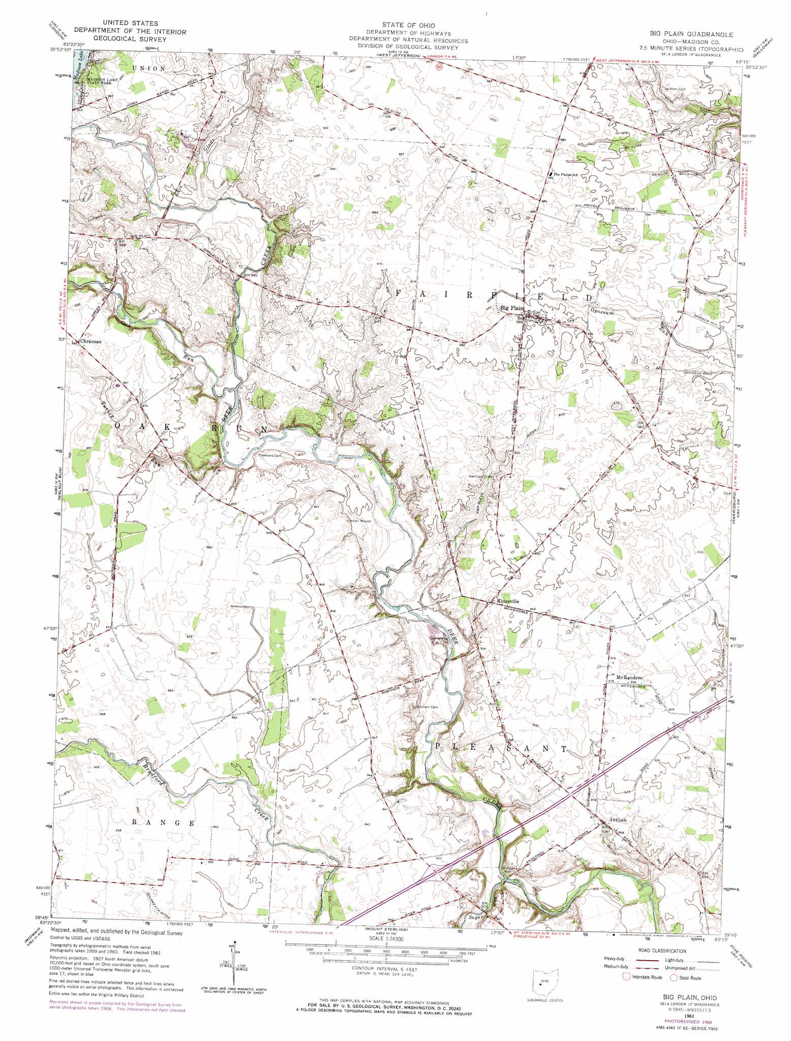
Big Plain Topo Map Ohio
To zoom in, hover over the map of Big Plain
USGS Topo Quad 39083g3 - 1:24,000 scale
| Topo Map Name: | Big Plain |
| USGS Topo Quad ID: | 39083g3 |
| Print Size: | ca. 21 1/4" wide x 27" high |
| Southeast Coordinates: | 39.75° N latitude / 83.25° W longitude |
| Map Center Coordinates: | 39.8125° N latitude / 83.3125° W longitude |
| U.S. State: | OH |
| Filename: | o39083g3.jpg |
| Download Map JPG Image: | Big Plain topo map 1:24,000 scale |
| Map Type: | Topographic |
| Topo Series: | 7.5´ |
| Map Scale: | 1:24,000 |
| Source of Map Images: | United States Geological Survey (USGS) |
| Alternate Map Versions: |
Big Plain OH 1961, updated 1962 Download PDF Buy paper map Big Plain OH 1961, updated 1968 Download PDF Buy paper map Big Plain OH 2010 Download PDF Buy paper map Big Plain OH 2013 Download PDF Buy paper map Big Plain OH 2016 Download PDF Buy paper map |
1:24,000 Topo Quads surrounding Big Plain
Mechanicsburg |
Plumwood |
Plain City |
Hilliard |
Northwest Columbus |
South Vienna |
London |
West Jefferson |
Galloway |
Southwest Columbus |
Florence |
Walnut Run |
Big Plain |
Harrisburg |
Commercial Point |
Jeffersonville |
Midway |
Mount Sterling |
Five Points |
Darbyville |
Milledgeville |
Washington Court House |
New Holland |
Clarksburg |
Williamsport |
> Back to 39083e1 at 1:100,000 scale
> Back to 39082a1 at 1:250,000 scale
> Back to U.S. Topo Maps home
Big Plain topo map: Gazetteer
Big Plain: Canals
Alkire Ditch elevation 279m 915′Childers Ditch elevation 282m 925′
Fitzgerald Ditch elevation 287m 941′
McGuire Ditch elevation 291m 954′
McGuire Gilliland Ditch elevation 287m 941′
Morain Ditch elevation 289m 948′
Robinson Ditch elevation 279m 915′
Van Cleve Ditch elevation 283m 928′
Big Plain: Crossings
Interchange 84 elevation 285m 935′Big Plain: Parks
Madison Lake State Park elevation 297m 974′Big Plain: Populated Places
Antioch elevation 277m 908′Big Plain elevation 300m 984′
Chrisman elevation 302m 990′
Kiousville elevation 285m 935′
McKendree elevation 285m 935′
Nioga (historical) elevation 289m 948′
Big Plain: Post Offices
Big Plain Post Office (historical) elevation 300m 984′Chrisman Post Office (historical) elevation 302m 990′
Kiousville Post Office (historical) elevation 286m 938′
Nioga Post Office (historical) elevation 289m 948′
Big Plain: Streams
Glade Run elevation 285m 935′Oak Run elevation 282m 925′
South Fork Bradford Creek elevation 293m 961′
Sugar Run elevation 266m 872′
Turkey Run elevation 280m 918′
Big Plain digital topo map on disk
Buy this Big Plain topo map showing relief, roads, GPS coordinates and other geographical features, as a high-resolution digital map file on DVD:
 map DVD")