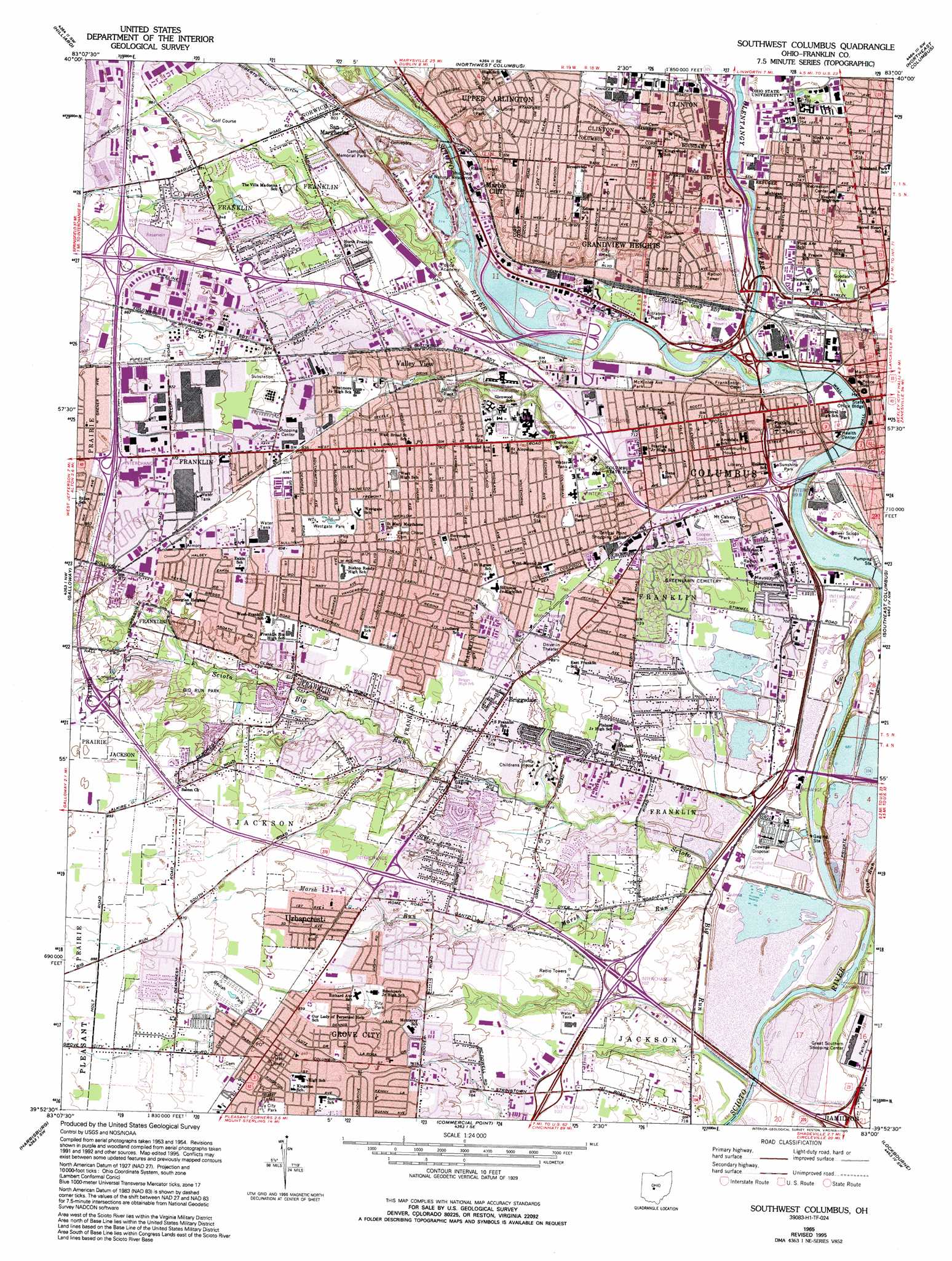
Southwest Columbus Topo Map Ohio
To zoom in, hover over the map of Southwest Columbus
USGS Topo Quad 39083h1 - 1:24,000 scale
| Topo Map Name: | Southwest Columbus |
| USGS Topo Quad ID: | 39083h1 |
| Print Size: | ca. 21 1/4" wide x 27" high |
| Southeast Coordinates: | 39.875° N latitude / 83° W longitude |
| Map Center Coordinates: | 39.9375° N latitude / 83.0625° W longitude |
| U.S. State: | OH |
| Filename: | o39083h1.jpg |
| Download Map JPG Image: | Southwest Columbus topo map 1:24,000 scale |
| Map Type: | Topographic |
| Topo Series: | 7.5´ |
| Map Scale: | 1:24,000 |
| Source of Map Images: | United States Geological Survey (USGS) |
| Alternate Map Versions: |
Southwest Columbus OH 1955, updated 1956 Download PDF Buy paper map Southwest Columbus OH 1965, updated 1967 Download PDF Buy paper map Southwest Columbus OH 1965, updated 1974 Download PDF Buy paper map Southwest Columbus OH 1965, updated 1982 Download PDF Buy paper map Southwest Columbus OH 1965, updated 1991 Download PDF Buy paper map Southwest Columbus OH 1965, updated 1995 Download PDF Buy paper map Southwest Columbus OH 2010 Download PDF Buy paper map Southwest Columbus OH 2013 Download PDF Buy paper map Southwest Columbus OH 2016 Download PDF Buy paper map |
1:24,000 Topo Quads surrounding Southwest Columbus
Marysville |
Shawnee Hills |
Powell |
Galena |
Sunbury |
Plain City |
Hilliard |
Northwest Columbus |
Northeast Columbus |
New Albany |
West Jefferson |
Galloway |
Southwest Columbus |
Southeast Columbus |
Reynoldsburg |
Big Plain |
Harrisburg |
Commercial Point |
Lockbourne |
Canal Winchester |
Mount Sterling |
Five Points |
Darbyville |
Ashville |
East Ringgold |
> Back to 39083e1 at 1:100,000 scale
> Back to 39082a1 at 1:250,000 scale
> Back to U.S. Topo Maps home
Southwest Columbus topo map: Gazetteer
Southwest Columbus: Airports
1328 Riverside Company Heliport elevation 226m 741′Columbus Heliport elevation 223m 731′
Department of Transportation Heliport elevation 218m 715′
Medical Center Heliport elevation 219m 718′
Minit-Men Incorporated Heliport elevation 221m 725′
Montoneys Airport elevation 256m 839′
Ohio Center Heliport elevation 228m 748′
Ranger Heliport elevation 243m 797′
Southwest Columbus: Bridges
Broad Street Bridge elevation 217m 711′Main Street Bridge elevation 216m 708′
Town Street Bridge elevation 215m 705′
Southwest Columbus: Crossings
Interchange 100 elevation 234m 767′Interchange 102 elevation 225m 738′
Interchange 104 elevation 217m 711′
Interchange 105 elevation 216m 708′
Interchange 2 elevation 251m 823′
Interchange 2C elevation 220m 721′
Interchange 2D elevation 218m 715′
Interchange 3 elevation 222m 728′
Interchange 4A elevation 236m 774′
Interchange 5 elevation 269m 882′
Interchange 52 elevation 215m 705′
Interchange 7 elevation 271m 889′
Interchange 93 elevation 269m 882′
Interchange 94 elevation 257m 843′
Interchange 95 elevation 242m 793′
Interchange 96 elevation 229m 751′
Interchange 97 elevation 216m 708′
Interchange 98A elevation 222m 728′
Interchange 99B elevation 216m 708′
Interchange 99C elevation 216m 708′
Southwest Columbus: Dams
Fifth Avenue Low Head Dam elevation 216m 708′Greenlawn Avenue Low Head Dam elevation 213m 698′
Rich Street Low Head Dam elevation 219m 718′
Southwest Columbus: Parks
Alexander Park elevation 219m 718′Arch Park elevation 224m 734′
Arena Park elevation 220m 721′
Battelle Riverfront Park elevation 220m 721′
Beulah Park elevation 261m 856′
Bicentennial Riverfront Park elevation 216m 708′
Big Run Park elevation 256m 839′
Campbell Memorial Park elevation 235m 770′
Childrens Park elevation 224m 734′
Cooper Stadium elevation 216m 708′
Dodge Park elevation 220m 721′
Fifth Avenue and North High Historic District elevation 231m 757′
Gantz Park elevation 233m 764′
Genoa Park elevation 219m 718′
Georgian Heights Park elevation 259m 849′
Glenwood Park elevation 226m 741′
Goodale Park elevation 229m 751′
Gowdy Park elevation 223m 731′
Greenlawn Park elevation 219m 718′
Grove City Park elevation 258m 846′
Harrison West Park elevation 225m 738′
Hauntz Park elevation 233m 764′
Hilltonia Park elevation 235m 770′
Hilltop Community Park elevation 238m 780′
Holton Park elevation 232m 761′
Ingram Spirit of Women Park elevation 219m 718′
Italian Village Park elevation 231m 757′
J W Galbreath Bicentennial Park elevation 218m 715′
Johnson Park elevation 218m 715′
Lindberg Park elevation 238m 780′
Lou Berliner Park elevation 214m 702′
Lower Scioto Park elevation 220m 721′
Maynard-Summit Park elevation 219m 718′
McCoy Park elevation 216m 708′
McKinley Avenue Park elevation 218m 715′
McKinley Field Park elevation 226m 741′
Memorial Park elevation 228m 748′
Miller Park elevation 246m 807′
North Market Historic District elevation 228m 748′
Pierce Field elevation 221m 725′
Redick Park elevation 242m 793′
Rhodes Park elevation 219m 718′
Richter Park elevation 225m 738′
River Bend Park elevation 243m 797′
Sader Park elevation 224m 734′
Scioto Woods Park elevation 253m 830′
Sensenbrenner Park elevation 226m 741′
Short North Historic District elevation 227m 744′
Stephens Drive Park elevation 254m 833′
Stoneridge Park elevation 239m 784′
Sullivant Gardens Park elevation 216m 708′
Sunshine Park elevation 216m 708′
The Arch elevation 224m 734′
Third Avenue and North High Historic District elevation 231m 757′
Thompson Park elevation 231m 757′
Upper Arlington Historic District elevation 249m 816′
Westbank Park elevation 217m 711′
Westgate Park elevation 251m 823′
Westmoore Park elevation 250m 820′
Wheeler Memorial Park elevation 229m 751′
Willow Creek Park elevation 217m 711′
Wrexham Park elevation 236m 774′
Wyman Woods Park elevation 221m 725′
Southwest Columbus: Populated Places
Briggsdale elevation 233m 764′Deems (historical) elevation 268m 879′
Grandview Heights elevation 236m 774′
Grove City elevation 259m 849′
Marble Cliff elevation 243m 797′
San Margherita elevation 242m 793′
Sullivants (historical) elevation 261m 856′
Upper Arlington elevation 247m 810′
Urbancrest elevation 256m 839′
Valley View elevation 237m 777′
Southwest Columbus: Post Offices
Briggsdale Post Office (historical) elevation 233m 764′Columbus Post Office elevation 220m 721′
Grove City Post Office elevation 258m 846′
Marblecliff Post Office (historical) elevation 243m 797′
Truro Post Office (historical) elevation 253m 830′
Urbancrest Post Office (historical) elevation 256m 839′
Southwest Columbus: Reservoirs
Fifth Avenue Low Head Reservoir elevation 216m 708′Greenlawn Avenue Low Head Reservoir elevation 213m 698′
Mirror Lake elevation 225m 738′
Rich Street Low Head Reservoir elevation 219m 718′
Southwest Columbus: Streams
Kian Run elevation 215m 705′Marsh Run elevation 213m 698′
Olentangy River elevation 217m 711′
Scioto Big Run elevation 207m 679′
Southwest Columbus digital topo map on disk
Buy this Southwest Columbus topo map showing relief, roads, GPS coordinates and other geographical features, as a high-resolution digital map file on DVD:
 map DVD")