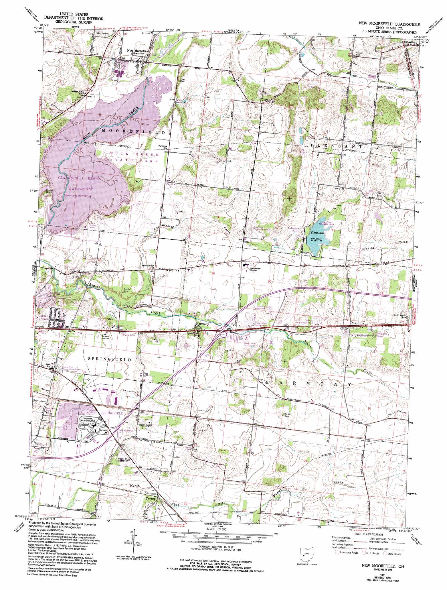
New Moorefield Topo Map Ohio
To zoom in, hover over the map of New Moorefield
USGS Topo Quad 39083h6 - 1:24,000 scale
| Topo Map Name: | New Moorefield |
| USGS Topo Quad ID: | 39083h6 |
| Print Size: | ca. 21 1/4" wide x 27" high |
| Southeast Coordinates: | 39.875° N latitude / 83.625° W longitude |
| Map Center Coordinates: | 39.9375° N latitude / 83.6875° W longitude |
| U.S. State: | OH |
| Filename: | o39083h6.jpg |
| Download Map JPG Image: | New Moorefield topo map 1:24,000 scale |
| Map Type: | Topographic |
| Topo Series: | 7.5´ |
| Map Scale: | 1:24,000 |
| Source of Map Images: | United States Geological Survey (USGS) |
| Alternate Map Versions: |
New Moorefield OH 1961, updated 1962 Download PDF Buy paper map New Moorefield OH 1961, updated 1969 Download PDF Buy paper map New Moorefield OH 1961, updated 1974 Download PDF Buy paper map New Moorefield OH 1961, updated 1982 Download PDF Buy paper map New Moorefield OH 1961, updated 1995 Download PDF Buy paper map New Moorefield OH 2010 Download PDF Buy paper map New Moorefield OH 2013 Download PDF Buy paper map New Moorefield OH 2016 Download PDF Buy paper map |
1:24,000 Topo Quads surrounding New Moorefield
Saint Paris |
Northville |
Kingscreek |
North Lewisburg |
Milford Center |
Thackery |
Urbana West |
Urbana East |
Mechanicsburg |
Plumwood |
Donnelsville |
Springfield |
New Moorefield |
South Vienna |
London |
Yellow Springs |
Clifton |
South Charleston |
Florence |
Walnut Run |
Xenia |
Cedarville |
Jamestown |
Jeffersonville |
Midway |
> Back to 39083e1 at 1:100,000 scale
> Back to 39082a1 at 1:250,000 scale
> Back to U.S. Topo Maps home
New Moorefield topo map: Gazetteer
New Moorefield: Airports
Kepes Flying Field elevation 328m 1076′New Moorefield: Crossings
Interchange 59 elevation 318m 1043′Interchange 62 elevation 320m 1049′
New Moorefield: Dams
Clarence J Brown Dam elevation 301m 987′Clark Lake Dam elevation 336m 1102′
New Moorefield: Parks
Buck Creek State Park elevation 317m 1040′Clark Lake Wildlife Area elevation 338m 1108′
Prairie Road Fen State Nature Preserve elevation 311m 1020′
Reid Memorial Park elevation 299m 980′
New Moorefield: Populated Places
Brookside Park Mobile Home Park elevation 337m 1105′Cherry Point Mobile Home Park elevation 330m 1082′
Crawford Mobile Home Park elevation 338m 1108′
Garden Acres elevation 329m 1079′
Harmony elevation 325m 1066′
Harmony Estates Mobile Home Park elevation 337m 1105′
Holiday Hills elevation 318m 1043′
Hollandia View elevation 349m 1145′
Lakeview Acres elevation 339m 1112′
New Moorefield elevation 320m 1049′
Oxtoby (historical) elevation 338m 1108′
Thorps elevation 330m 1082′
New Moorefield: Post Offices
Harmony Post Office (historical) elevation 332m 1089′New Moorefield Post Office (historical) elevation 319m 1046′
Oxtoby Post Office (historical) elevation 338m 1108′
Summerford Post Office (historical) elevation 333m 1092′
New Moorefield: Reservoirs
Clarence J Brown Reservoir elevation 301m 987′Clark Lake elevation 336m 1102′
New Moorefield: Streams
Sinking Creek elevation 306m 1003′New Moorefield: Summits
The Knobs elevation 380m 1246′New Moorefield: Trails
Lakeview Trail elevation 312m 1023′New Moorefield digital topo map on disk
Buy this New Moorefield topo map showing relief, roads, GPS coordinates and other geographical features, as a high-resolution digital map file on DVD:
 map DVD")