Withamsville Topo Map Ohio
To zoom in, hover over the map of Withamsville
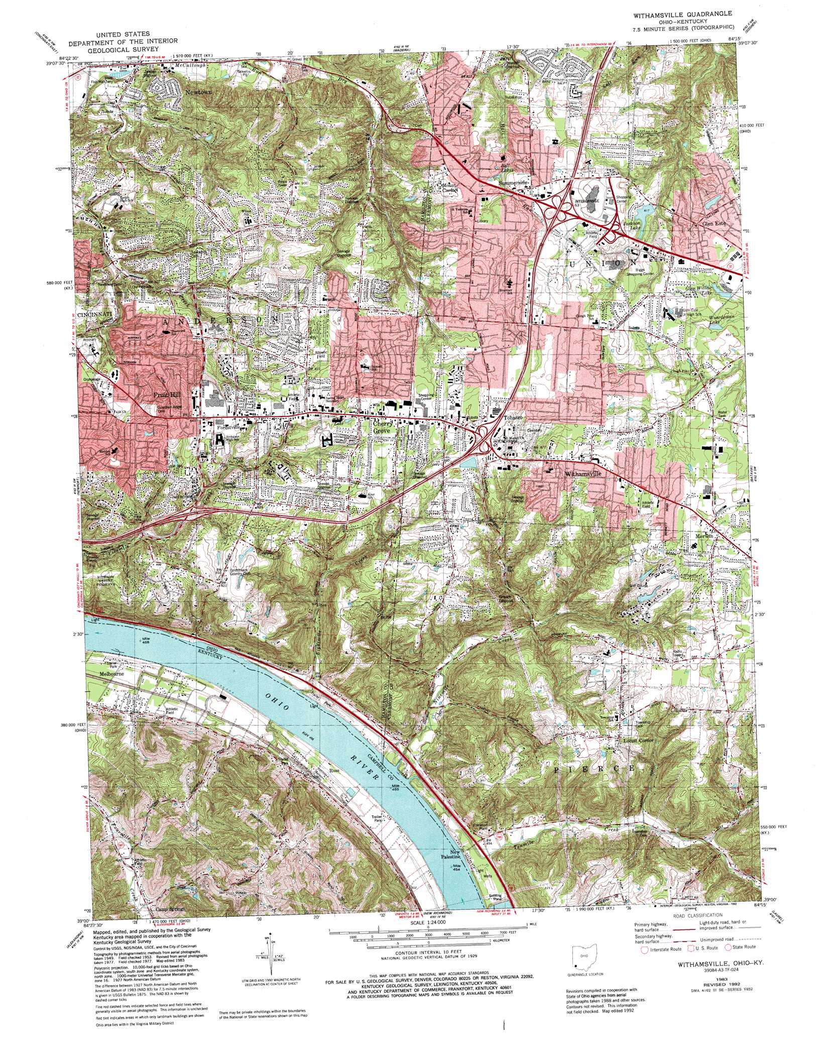
USGS Topo Quad 39084a3 - 1:24,000 scale
| Topo Map Name: | Withamsville |
| USGS Topo Quad ID: | 39084a3 |
| Print Size: | ca. 21 1/4" wide x 27" high |
| Southeast Coordinates: | 39° N latitude / 84.25° W longitude |
| Map Center Coordinates: | 39.0625° N latitude / 84.3125° W longitude |
| U.S. States: | OH, KY |
| Filename: | o39084a3.jpg |
| Download Map JPG Image: | Withamsville topo map 1:24,000 scale |
| Map Type: | Topographic |
| Topo Series: | 7.5´ |
| Map Scale: | 1:24,000 |
| Source of Map Images: | United States Geological Survey (USGS) |
| Alternate Map Versions: |
Withamsville OH 1953, updated 1955 Download PDF Buy paper map Withamsville OH 1961, updated 1963 Download PDF Buy paper map Withamsville OH 1961, updated 1971 Download PDF Buy paper map Withamsville OH 1961, updated 1975 Download PDF Buy paper map Withamsville OH 1983, updated 1984 Download PDF Buy paper map Withamsville OH 1983, updated 1987 Download PDF Buy paper map Withamsville OH 1983, updated 1992 Download PDF Buy paper map Withamsville OH 1983, updated 1992 Download PDF Buy paper map Withamsvile OH 1996, updated 1999 Download PDF Buy paper map Withamsville OH 2010 Download PDF Buy paper map Withamsville OH 2013 Download PDF Buy paper map Withamsville OH 2016 Download PDF Buy paper map |
1:24,000 Topo Quads surrounding Withamsville
Greenhills |
Glendale |
Mason |
South Lebanon |
Pleasant Plain |
Cincinnati West |
Cincinnati East |
Madeira |
Goshen |
Newtonsville |
Covington |
Newport |
Withamsville |
Batavia |
Williamsburg |
Independence |
Alexandria |
New Richmond |
Laurel |
Bethel |
Walton |
De Mossville |
Butler |
Moscow |
Felicity |
> Back to 39084a1 at 1:100,000 scale
> Back to 39084a1 at 1:250,000 scale
> Back to U.S. Topo Maps home
Withamsville topo map: Gazetteer
Withamsville: Airports
Mays Heliport elevation 152m 498′Withamsville: Crossings
Interchange 63 elevation 265m 869′Interchange 65 elevation 275m 902′
Interchange 69 elevation 221m 725′
Withamsville: Dams
Coldstream Country Club Lake Dam elevation 236m 774′Glen Ridge Lake Dam elevation 246m 807′
Warrenton Farms Dam elevation 262m 859′
Withamsville: Harbors
Shady Lane Boat Harbor elevation 139m 456′Withamsville: Lakes
Bell Lakes elevation 252m 826′Beulah Lake elevation 265m 869′
Withamsville: Parks
Alp Memorial Park elevation 244m 800′Brown Stadium elevation 239m 784′
Clepper Park elevation 253m 830′
Forest Road Park elevation 262m 859′
Martz Playgrounds (historical) elevation 147m 482′
Mount Carmel Park elevation 266m 872′
Nagel Road Park elevation 258m 846′
Pierce Township Nature Area elevation 258m 846′
Pierce Township Park elevation 258m 846′
Veterans Park elevation 274m 898′
Withamsville-Tobasco Park elevation 277m 908′
Withamsville: Populated Places
Alpine Terrace elevation 273m 895′Am-Beth Acres elevation 280m 918′
Asbury elevation 253m 830′
Britney Acres elevation 257m 843′
Camp Springs elevation 162m 531′
Cherry Grove elevation 266m 872′
Clough Heights elevation 273m 895′
Dry Run elevation 266m 872′
Eightmile elevation 149m 488′
Ellenora elevation 216m 708′
Fernell Heights elevation 262m 859′
Forest Hills Estates elevation 268m 879′
Forestville elevation 250m 820′
Fruit Hill elevation 221m 725′
Glen Este elevation 261m 856′
Glen Ridge Acres elevation 250m 820′
Hill Craft Acres elevation 280m 918′
Home (historical) elevation 150m 492′
Huntcrest Acres elevation 255m 836′
Lawyerdale Estates elevation 244m 800′
Locust Corner elevation 263m 862′
Melbourne elevation 153m 501′
Merwin elevation 272m 892′
Mount Carmel elevation 270m 885′
Mount Carmel Heights elevation 256m 839′
Mount Forest Trails elevation 268m 879′
Mount Summit elevation 267m 875′
New Palestine elevation 150m 492′
Newtown elevation 152m 498′
Ninemile elevation 168m 551′
Paddison Hills elevation 223m 731′
Ross elevation 152m 498′
Sherwood elevation 221m 725′
Sherwood Village elevation 217m 711′
Spann (historical) elevation 169m 554′
Summerside elevation 268m 879′
Summerside Estates elevation 252m 826′
Tobasco elevation 275m 902′
Valley View Heights elevation 250m 820′
Vermona elevation 264m 866′
Viking Village elevation 272m 892′
Watch Hill elevation 234m 767′
Withamsville elevation 268m 879′
Withamsville: Post Offices
Asbury Post Office (historical) elevation 253m 830′Cherry Grove Post Office (historical) elevation 265m 869′
Eightmile Post Office (historical) elevation 149m 488′
Ellenora Post Office (historical) elevation 217m 711′
Forestville Post Office (historical) elevation 250m 820′
Fruithill Post Office (historical) elevation 220m 721′
Glen Este Post Office (historical) elevation 260m 853′
Locust Corner Post Office (historical) elevation 264m 866′
Melbourne Post Office elevation 154m 505′
Merwin Post Office (historical) elevation 272m 892′
Mount Carmel Post Office (historical) elevation 271m 889′
Mount Summit Post Office (historical) elevation 267m 875′
New Palestine Post Office (historical) elevation 145m 475′
Newtown Post Office (historical) elevation 156m 511′
Ninemile Post Office (historical) elevation 174m 570′
Ross Post Office (historical) elevation 152m 498′
Spann Post Office (historical) elevation 178m 583′
Summerside Post Office (historical) elevation 266m 872′
Symmes Post Office (historical) elevation 281m 921′
Tobasco Post Office (historical) elevation 275m 902′
Withamsville Post Office (historical) elevation 269m 882′
Withamsville: Reservoirs
Coldstream Country Club Lake elevation 236m 774′Glen Ridge Lake elevation 246m 807′
Glen Willow Lake elevation 256m 839′
Jackson Lake elevation 238m 780′
Royal Oaks Course Pond Number Two elevation 259m 849′
Royal Oaks Golf Course Pond Number One elevation 269m 882′
Warrenton Farms Pond elevation 262m 859′
White Lake elevation 263m 862′
Wuerdeman Lakes elevation 259m 849′
Withamsville: Streams
Eightmile Creek elevation 141m 462′Ninemile Creek elevation 140m 459′
Seven Mile Creek elevation 137m 449′
Tenmile Creek elevation 141m 462′
Tenmile Creek elevation 141m 462′
Withamsville digital topo map on disk
Buy this Withamsville topo map showing relief, roads, GPS coordinates and other geographical features, as a high-resolution digital map file on DVD:
Northern Illinois, Northern Indiana & Southwestern Michigan
Buy digital topo maps: Northern Illinois, Northern Indiana & Southwestern Michigan