Covington Topo Map Kentucky
To zoom in, hover over the map of Covington
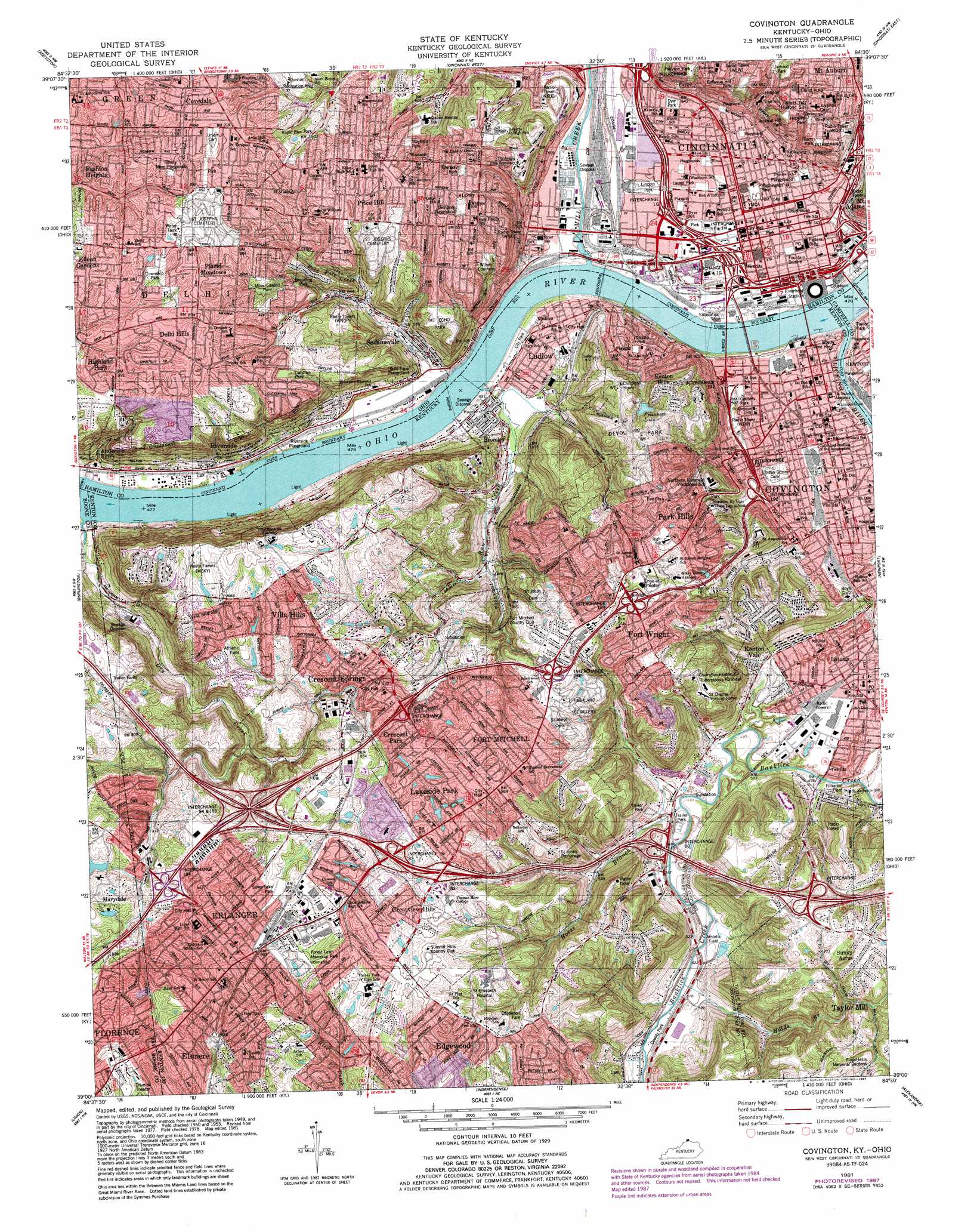
USGS Topo Quad 39084a5 - 1:24,000 scale
| Topo Map Name: | Covington |
| USGS Topo Quad ID: | 39084a5 |
| Print Size: | ca. 21 1/4" wide x 27" high |
| Southeast Coordinates: | 39° N latitude / 84.5° W longitude |
| Map Center Coordinates: | 39.0625° N latitude / 84.5625° W longitude |
| U.S. States: | KY, OH |
| Filename: | o39084a5.jpg |
| Download Map JPG Image: | Covington topo map 1:24,000 scale |
| Map Type: | Topographic |
| Topo Series: | 7.5´ |
| Map Scale: | 1:24,000 |
| Source of Map Images: | United States Geological Survey (USGS) |
| Alternate Map Versions: |
Covington KY 1950, updated 1953 Download PDF Buy paper map Covington KY 1955, updated 1957 Download PDF Buy paper map Covington KY 1961, updated 1963 Download PDF Buy paper map Covington KY 1961, updated 1970 Download PDF Buy paper map Covington KY 1961, updated 1978 Download PDF Buy paper map Covington KY 1981, updated 1981 Download PDF Buy paper map Covington KY 1981, updated 1987 Download PDF Buy paper map Covington KY 2010 Download PDF Buy paper map Covington KY 2013 Download PDF Buy paper map Covington KY 2016 Download PDF Buy paper map |
1:24,000 Topo Quads surrounding Covington
Harrison |
Shandon |
Greenhills |
Glendale |
Mason |
Hooven |
Addyston |
Cincinnati West |
Cincinnati East |
Madeira |
Lawrenceburg |
Burlington |
Covington |
Newport |
Withamsville |
Rising Sun |
Union |
Independence |
Alexandria |
New Richmond |
Patriot |
Verona |
Walton |
De Mossville |
Butler |
> Back to 39084a1 at 1:100,000 scale
> Back to 39084a1 at 1:250,000 scale
> Back to U.S. Topo Maps home
Covington topo map: Gazetteer
Covington: Airports
9 Newsport Heliport elevation 160m 524′Brown Heliport elevation 265m 869′
Christ Hospital Heliport elevation 254m 833′
Saint Elizabeth Medical Center South Heliport elevation 258m 846′
Covington: Bridges
Central Bridge elevation 136m 446′Clay Wade Bailey Bridge elevation 138m 452′
Fourth Street Bridge elevation 137m 449′
Gilbert Avenue Viaduct elevation 159m 521′
John A Roebling Bridge elevation 137m 449′
Spence Bridge elevation 139m 456′
West Eighth Street Viaduct elevation 139m 456′
West Sixth Street Viaduct elevation 139m 456′
Western Hills Viaduct elevation 140m 459′
Covington: Crossings
Covington Ferry (historical) elevation 136m 446′Fifth Street Ferry (historical) elevation 134m 439′
Interchange 184 elevation 257m 843′
Interchange 185 elevation 249m 816′
Interchange 186 elevation 249m 816′
Interchange 188 elevation 252m 826′
Interchange 189 elevation 267m 875′
Interchange 190 elevation 157m 515′
Interchange 191 elevation 152m 498′
Interchange 192 elevation 155m 508′
Interchange 1F and 1G elevation 165m 541′
Interchange 1F and 1H elevation 158m 518′
Interchange 1G elevation 152m 498′
Interchange 2 elevation 158m 518′
Interchange 3 elevation 179m 587′
Interchange 79 elevation 242m 793′
Interchange 80 elevation 163m 534′
Interchange 82 elevation 260m 853′
Interchange 83 elevation 258m 846′
Interchange 84 elevation 249m 816′
Kennedys Ferry (historical) elevation 137m 449′
Covington: Harbors
Twentyfirst Century Boat Harbor elevation 141m 462′Covington: Mines
Bald Knob Quarry elevation 216m 708′Dodson Quarry elevation 244m 800′
Goforth Quarry elevation 233m 764′
Goodhue Quarry elevation 209m 685′
Neff Quarry elevation 236m 774′
Price Quarry elevation 237m 777′
Wilder Quarry elevation 233m 764′
Covington: Parks
Bellevue Hill Park elevation 239m 784′Betts-Longworth Historic District elevation 164m 538′
Breuning Park elevation 220m 721′
Cinergy Field elevation 146m 479′
Crosley Field (historical) elevation 149m 488′
Cutter Playground elevation 169m 554′
Dayton Street Historic District elevation 165m 541′
Deer Creek Common elevation 186m 610′
Delhi Township Park elevation 260m 853′
Delshire Park elevation 257m 843′
Dempsey Playground elevation 251m 823′
Devou Park elevation 262m 859′
Dunham Recreation Area elevation 256m 839′
Dyer Park elevation 162m 531′
East Fourth Street Historic District elevation 164m 538′
Edgewood Park elevation 266m 872′
Embshoff Woods and Nature Preserve elevation 249m 816′
Fairview Park elevation 223m 731′
Filson Park elevation 245m 803′
Findlay Playground elevation 164m 538′
Fort Washington Monument elevation 156m 511′
Fort Washington Park elevation 156m 511′
Fountain Square elevation 167m 547′
Frazen Park elevation 255m 836′
Garfield Park elevation 168m 551′
General James Taylor Park elevation 148m 485′
General Ormsby Mitchell Park elevation 250m 820′
Glenway Park elevation 262m 859′
Goebels Park elevation 153m 501′
Government Square elevation 168m 551′
Grant Playground elevation 169m 554′
Great American Ballpark elevation 146m 479′
Haberstumpfs Garden elevation 259m 849′
Hanna Playground elevation 164m 538′
Hendy Memorial Playground elevation 270m 885′
Hopkins Park elevation 248m 813′
Hopkins Park elevation 248m 813′
Inwood Park elevation 249m 816′
Jackson Hill Park elevation 255m 836′
Laurel Homes Historic District elevation 158m 518′
Laurel Playground elevation 160m 524′
Laurel Recreation Area elevation 157m 515′
Lincoln Park elevation 152m 498′
Lincoln Playground elevation 154m 505′
Ludlow Lagoon Amusement Park (historical) elevation 141m 462′
Ludlow Stadium elevation 148m 485′
Lytle Park elevation 166m 544′
Lytle Park Historic District elevation 165m 541′
Mayfield Park elevation 253m 830′
McMicken-Klotter Playground elevation 175m 574′
Miles Edwards Park elevation 260m 853′
Milton-Boal Playground elevation 203m 666′
Mohawk Park elevation 165m 541′
Mount Auburn Historic District elevation 258m 846′
Mount Auburn Recreation Center elevation 251m 823′
Mount Echo Park elevation 248m 813′
National Steamboat Monument elevation 144m 472′
National Underground Railroad Freedom Center elevation 149m 488′
Ninth Street Historic District elevation 168m 551′
Northern Row Park elevation 167m 547′
Over the Rhine Recreation Center elevation 165m 541′
Over-the-Rhine Historic District elevation 251m 823′
Panther Athletic Complex elevation 239m 784′
Paul Brown Stadium elevation 151m 495′
Pecks Cliff Park elevation 208m 682′
Pete Rose Park elevation 149m 488′
Piatt Park elevation 168m 551′
Pioneer Park elevation 151m 495′
President's Park elevation 273m 895′
Probasco Fountain elevation 168m 551′
Prospect Hill Historic District elevation 250m 820′
Queensgate Playfield elevation 155m 508′
Race Street Children's Garden elevation 165m 541′
Rapid Run Park elevation 253m 830′
Reakirt Fountain elevation 241m 790′
Rigney Park elevation 249m 816′
Riverbreeze Ballpark (historical) elevation 152m 498′
Riverfront Stadium (historical) elevation 146m 479′
Riverside Playground elevation 144m 472′
Sabin Park elevation 154m 505′
Saint Paul Church Historic District elevation 171m 561′
Sands Playground elevation 155m 508′
Silver Lake Park elevation 262m 859′
Spring Street Playground elevation 171m 561′
The Pit elevation 255m 836′
Tyler Davidson Fountain elevation 168m 551′
US Bank Arena elevation 150m 492′
Washington Park elevation 168m 551′
Weaver Playground elevation 156m 511′
West Fourth Street Historic District elevation 165m 541′
Whittier Gardens elevation 255m 836′
Wielerts Garden (historical) elevation 165m 541′
William H Taft Historical Site elevation 257m 843′
William Howard Taft National Historic Site elevation 257m 843′
Wilson Common elevation 218m 715′
Wooten Stadium elevation 252m 826′
Yeatmans Cove Park elevation 142m 465′
Ziegler Park elevation 164m 538′
Covington: Populated Places
Amsterdam (historical) elevation 241m 790′Anderson Ferry elevation 161m 528′
Barrsville elevation 156m 511′
Brighton Corner elevation 156m 511′
Bromley elevation 155m 508′
Bucktown (historical) elevation 158m 518′
Cloud City (historical) elevation 250m 820′
Covedale elevation 270m 885′
Covington elevation 155m 508′
Crescent Park elevation 256m 839′
Crescent Springs elevation 251m 823′
Crestview Hills elevation 262m 859′
Delhi elevation 274m 898′
Delhi Hills elevation 266m 872′
East Price Hill elevation 261m 856′
Edgewood elevation 263m 862′
Eileen Gardens elevation 270m 885′
Elsmere elevation 280m 918′
Erlanger elevation 278m 912′
Fashion Heights elevation 273m 895′
Forest Hills elevation 161m 528′
Fort Mitchell elevation 260m 853′
Fort Wright elevation 258m 846′
Frenchmens Corner (historical) elevation 155m 508′
Highland Park elevation 258m 846′
Jacob Price Homes elevation 159m 521′
Jerusalem elevation 200m 656′
Kenton Hills elevation 248m 813′
Kenton Vale elevation 161m 528′
Lakeside Park elevation 259m 849′
Lakeview elevation 160m 524′
Latonia elevation 162m 531′
Latonia Terrace elevation 159m 521′
Laurel Homes elevation 158m 518′
Lincoln Court elevation 157m 515′
Little Bethlehem elevation 256m 839′
Little Buck (historical) elevation 150m 492′
Lookout Heights elevation 251m 823′
Lower Price Hill elevation 157m 515′
Ludlow elevation 164m 538′
Marydale elevation 270m 885′
Maurice elevation 153m 501′
Monterey elevation 257m 843′
Mount Auburn elevation 220m 721′
Mount Harrison elevation 262m 859′
Over-The-Rhine elevation 165m 541′
Park Hills elevation 229m 751′
Placid Meadows elevation 270m 885′
Price Hill elevation 253m 830′
Prospect Hill elevation 246m 807′
Riverside elevation 153m 501′
Saint Lawrence Corners elevation 265m 869′
Sandfordtown (historical) elevation 152m 498′
Sanfordtown elevation 171m 561′
Sanfordtown (historical) elevation 162m 531′
Sedamsville elevation 167m 547′
South Fort Mitchell elevation 258m 846′
Storrs elevation 161m 528′
Summit Hills Heights elevation 255m 836′
Villa Hills elevation 259m 849′
West Covington elevation 181m 593′
West Covington (historical) elevation 180m 590′
West Price Hill elevation 270m 885′
Winston Park elevation 159m 521′
Covington: Post Offices
Andersons Ferry Post Office (historical) elevation 154m 505′Cincinnati Post Office elevation 168m 551′
Covedale Post Office (historical) elevation 270m 885′
Covington Post Office elevation 156m 511′
Crescent Springs Post Office (historical) elevation 240m 787′
Delhi Post Office (historical) elevation 275m 902′
Florence Post Office elevation 281m 921′
Latonia Station Covinton Post Office elevation 162m 531′
Milldale Post Office (historical) elevation 162m 531′
Riverside Post Office (historical) elevation 158m 518′
Saint Johns Asylum Post Office (historical) elevation 264m 866′
Sandfordtown Post Office (historical) elevation 149m 488′
Storrs Post Office (historical) elevation 159m 521′
Timberlake Post Office (historical) elevation 277m 908′
Weavers Mill Post Office (historical) elevation 152m 498′
White House Post Office (historical) elevation 161m 528′
Covington: Reservoirs
Prisoners Lake elevation 222m 728′Silver Pond elevation 268m 879′
Covington: Streams
Bold Face Creek elevation 162m 531′Chippy Run elevation 139m 456′
Dry Creek elevation 139m 456′
Dry Run elevation 140m 459′
Flehers Run elevation 139m 456′
Hatchers Run elevation 140m 459′
Holds Branch elevation 151m 495′
Horse Branch elevation 155m 508′
Licking River elevation 137m 449′
Mill Creek elevation 138m 452′
Pleasant Run Creek elevation 140m 459′
Covington: Summits
Bald Knob elevation 233m 764′Brighton Hill elevation 257m 843′
Goat Hill elevation 250m 820′
Orchard Hill elevation 260m 853′
Covington: Woods
Barrs Woods (historical) elevation 162m 531′Findlay's Woods (historical) elevation 165m 541′
Covington digital topo map on disk
Buy this Covington topo map showing relief, roads, GPS coordinates and other geographical features, as a high-resolution digital map file on DVD:
Northern Illinois, Northern Indiana & Southwestern Michigan
Buy digital topo maps: Northern Illinois, Northern Indiana & Southwestern Michigan