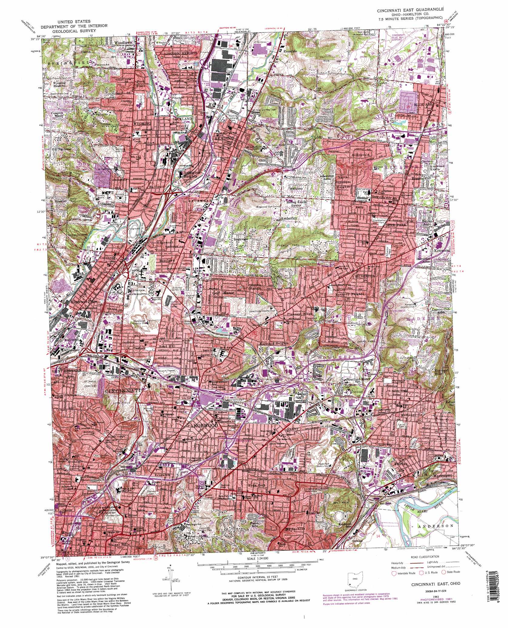
Cincinnati East Topo Map Ohio
To zoom in, hover over the map of Cincinnati East
USGS Topo Quad 39084b4 - 1:24,000 scale
| Topo Map Name: | Cincinnati East |
| USGS Topo Quad ID: | 39084b4 |
| Print Size: | ca. 21 1/4" wide x 27" high |
| Southeast Coordinates: | 39.125° N latitude / 84.375° W longitude |
| Map Center Coordinates: | 39.1875° N latitude / 84.4375° W longitude |
| U.S. State: | OH |
| Filename: | o39084b4.jpg |
| Download Map JPG Image: | Cincinnati East topo map 1:24,000 scale |
| Map Type: | Topographic |
| Topo Series: | 7.5´ |
| Map Scale: | 1:24,000 |
| Source of Map Images: | United States Geological Survey (USGS) |
| Alternate Map Versions: |
Cincinnati East OH 1953, updated 1955 Download PDF Buy paper map Cincinnati East OH 1961, updated 1963 Download PDF Buy paper map Cincinnati East OH 1961, updated 1971 Download PDF Buy paper map Cincinnati East OH 1961, updated 1975 Download PDF Buy paper map Cincinnati East OH 1961, updated 1982 Download PDF Buy paper map Cincinnati East OH 1961, updated 1988 Download PDF Buy paper map Cincinnati East OH 1961, updated 1988 Download PDF Buy paper map Cincinnati East OH 2010 Download PDF Buy paper map Cincinnati East OH 2013 Download PDF Buy paper map Cincinnati East OH 2016 Download PDF Buy paper map |
1:24,000 Topo Quads surrounding Cincinnati East
Millville |
Hamilton |
Trenton |
Monroe |
Lebanon |
Shandon |
Greenhills |
Glendale |
Mason |
South Lebanon |
Addyston |
Cincinnati West |
Cincinnati East |
Madeira |
Goshen |
Burlington |
Covington |
Newport |
Withamsville |
Batavia |
Union |
Independence |
Alexandria |
New Richmond |
Laurel |
> Back to 39084a1 at 1:100,000 scale
> Back to 39084a1 at 1:250,000 scale
> Back to U.S. Topo Maps home
Cincinnati East topo map: Gazetteer
Cincinnati East: Airports
Cincinnati-Blue Ash Airport elevation 255m 836′Cincinnati East: Crossings
Interchange 10 elevation 207m 679′Interchange 10 elevation 165m 541′
Interchange 11 elevation 256m 839′
Interchange 12 elevation 173m 567′
Interchange 13 elevation 172m 564′
Interchange 14 elevation 166m 544′
Interchange 14 elevation 173m 567′
Interchange 5 elevation 202m 662′
Interchange 6 elevation 193m 633′
Interchange 7 elevation 170m 557′
Interchange 8 elevation 169m 554′
Interchange 8 elevation 156m 511′
Interchange 9 elevation 164m 538′
Interchange 9 elevation 183m 600′
Cincinnati East: Parks
Annwood Park elevation 235m 770′Ault Park elevation 193m 633′
Avon Field elevation 188m 616′
Blue Ash Recreation Center elevation 266m 872′
Bond Hill Park elevation 186m 610′
Bramble Park elevation 169m 554′
Burwood Playground elevation 192m 629′
Caldwell Park elevation 169m 554′
Centennial Park elevation 172m 564′
Chamberlin Park elevation 260m 853′
Corcoran Field elevation 181m 593′
Dale Park elevation 171m 561′
Dar Field elevation 189m 620′
Dogwood Park elevation 159m 521′
Dorl Field elevation 189m 620′
Drake Park elevation 238m 780′
Elmwood Place Memorial Park elevation 163m 534′
Evanston Playground elevation 209m 685′
Fenwick Park elevation 190m 623′
Fleischmann Gardens elevation 222m 728′
French Park elevation 209m 685′
Hauck Botanic Gardens elevation 247m 810′
Hayden Field elevation 180m 590′
Hoffman Playground elevation 238m 780′
Hoyes Field elevation 204m 669′
Hunter Park elevation 189m 620′
Hyde Park Square elevation 202m 662′
Kennedy Heights Park elevation 234m 767′
Koening Park elevation 167m 547′
Little Duck Creek Park elevation 169m 554′
M L King Junior Park elevation 218m 715′
Madison and Woodburn Historic District elevation 247m 810′
Madison Park elevation 203m 666′
Madison-Stewart Historic District elevation 179m 587′
Mariemont Gardens Park elevation 147m 482′
Mariemont Municipal Swimming Pool elevation 163m 534′
Marsh Avenue Park elevation 190m 623′
Millcrest Park elevation 185m 606′
Mitchell Triangle elevation 220m 721′
Oakley Playground elevation 180m 590′
O'Brien Terrace elevation 196m 643′
Observatory Historic District elevation 235m 770′
Owls Nest Park elevation 225m 738′
Peebles Corner Historic District elevation 256m 839′
Pleasant Ridge Park elevation 230m 754′
Roettger Field elevation 165m 541′
Roselawn Park elevation 177m 580′
Ross Avenue Park elevation 162m 531′
Saint Francis De Sales Church Historic District elevation 247m 810′
Scarborough Woods elevation 244m 800′
Seasongoer Square elevation 219m 718′
Seymour Nature Preserve elevation 176m 577′
Silverton Field elevation 262m 859′
Stella Park elevation 195m 639′
Tower Park elevation 229m 751′
Victory Park elevation 197m 646′
Village Historic District elevation 181m 593′
Voorhees Park elevation 166m 544′
Waterworks Park elevation 181m 593′
Woodford Park elevation 211m 692′
Woodward Park elevation 212m 695′
Wulsin Triangle elevation 220m 721′
Wyoming Park elevation 200m 656′
Cincinnati East: Populated Places
Amberley elevation 243m 797′Amity elevation 259m 849′
Arbocrest Acres elevation 250m 820′
Arlington Heights elevation 169m 554′
Avondale elevation 219m 718′
Beechwood elevation 258m 846′
Blue Ash elevation 258m 846′
Bond Hill elevation 187m 613′
Brookhill elevation 254m 833′
Brookwood elevation 192m 629′
Carthage elevation 166m 544′
Cincinnati elevation 191m 626′
Clare elevation 148m 485′
Compton Woods elevation 247m 810′
Country Club Acres elevation 260m 853′
Dallmans Corner elevation 241m 790′
Deer Park elevation 265m 869′
Dillionvale elevation 253m 830′
Dillonvale elevation 239m 784′
East Madisonville elevation 184m 603′
Edgemont elevation 182m 597′
Elmwood Place elevation 158m 518′
Evanston elevation 221m 725′
Fairfax elevation 172m 564′
Faxon Hills elevation 204m 669′
Golf Manor elevation 201m 659′
Harewood Acres elevation 264m 866′
Hartwell elevation 167m 547′
Hill Top Acres elevation 259m 849′
Holiday Acres elevation 258m 846′
Hyde Park elevation 204m 669′
Idlewild elevation 205m 672′
Idlewood elevation 203m 666′
Indian Hill elevation 225m 738′
Ivorydale elevation 161m 528′
Kennedy Heights elevation 238m 780′
Kenwood Hills elevation 266m 872′
Kenwood Knolls elevation 248m 813′
Lincoln Heights elevation 181m 593′
Linwood elevation 150m 492′
Lockland elevation 177m 580′
Madisonville elevation 184m 603′
Mount Lookout elevation 178m 583′
North Sagamore Heights elevation 251m 823′
Norwood elevation 200m 656′
Norwood Heights elevation 211m 692′
Oakley elevation 179m 587′
Oakley Square elevation 186m 610′
O'Bryonsville elevation 226m 741′
Park Place elevation 185m 606′
Peebles Corner elevation 256m 839′
Pleasant Ridge elevation 241m 790′
Reading elevation 171m 561′
Red Bank elevation 151m 495′
Rendcomb Junction elevation 150m 492′
Rolling Knolls Estate elevation 247m 810′
Roselawn elevation 179m 587′
Rossmoyne elevation 254m 833′
Saint Bernard elevation 170m 557′
Silverton elevation 259m 849′
Stratford Manor elevation 183m 600′
Valleydale elevation 164m 538′
Walnut Hills elevation 243m 797′
Whitetree elevation 247m 810′
Woodburn elevation 247m 810′
Wyoming elevation 175m 574′
Wyoming Meadows elevation 246m 807′
Cincinnati East: Post Offices
Arlington Heights Post Office (historical) elevation 169m 554′Beechwood Post Office (historical) elevation 259m 849′
Blue Ash Post Office (historical) elevation 261m 856′
Bond Hill Post Office (historical) elevation 187m 613′
Carthage Post Office (historical) elevation 166m 544′
Deer Park Post Office (historical) elevation 265m 869′
Elmwood Place Post Office (historical) elevation 159m 521′
Hartwell Post Office (historical) elevation 167m 547′
Hydepark Post Office (historical) elevation 204m 669′
Idlewild Post Office (historical) elevation 205m 672′
Indian Hill Post Office (historical) elevation 205m 672′
Ivorydale Post Office (historical) elevation 161m 528′
Linwood Post Office (historical) elevation 150m 492′
Lockland Post Office (historical) elevation 177m 580′
Madisonville Post Office (historical) elevation 182m 597′
Mount Lookout Post Office (historical) elevation 179m 587′
Norwood Post Office elevation 194m 636′
Oakley Post Office (historical) elevation 179m 587′
Pleasant Ridge Post Office (historical) elevation 241m 790′
Reading Post Office (historical) elevation 172m 564′
Red Bank Post Office (historical) elevation 156m 511′
Rossmoyne Post Office (historical) elevation 254m 833′
Saint Bernard Post Office (historical) elevation 167m 547′
Silverton Post Office (historical) elevation 259m 849′
Walnut Hills Post Office (historical) elevation 246m 807′
Wyoming Post Office (historical) elevation 174m 570′
Cincinnati East: Ranges
Walnut Hills elevation 249m 816′Cincinnati East: Streams
Congress Run elevation 156m 511′West Fork Mill Creek elevation 161m 528′
Cincinnati East digital topo map on disk
Buy this Cincinnati East topo map showing relief, roads, GPS coordinates and other geographical features, as a high-resolution digital map file on DVD:
Northern Illinois, Northern Indiana & Southwestern Michigan
Buy digital topo maps: Northern Illinois, Northern Indiana & Southwestern Michigan